It is noted that while the majority of recommendations set out in response to the submission of the EMRA (dated 25th June 2020) were accepted, the Planning Authority resolved not to comply with a...
Volume 2 Book of Maps
Closed15 Dec, 2020, 9:00am - 20 Jan, 2021, 5:00pm
DOWNLOAD VOLUME 2 - MATERIAL AMENDMENTS
![]()
Volume 2
Book of Maps: Material Amendments
Individual maps can be viewed from the Contents menu on the right.
An interactive viewer is also provided for some maps below.
Interactive Maps Viewer
Book of Maps: Material Amendments
Download PDF
|
Proposed Amendment BOM 1 |
|
|
Title |
Map No. |
|
Castlepollard Zoning |
2 |
Change zoning from unzoned to “Proposed Residential”

|
Proposed Amendment BOM 2 |
|
|
Title |
Map No. |
|
Castlepollard Zoning |
2 |
Change zoning from unzoned to “Consolidation Site”

|
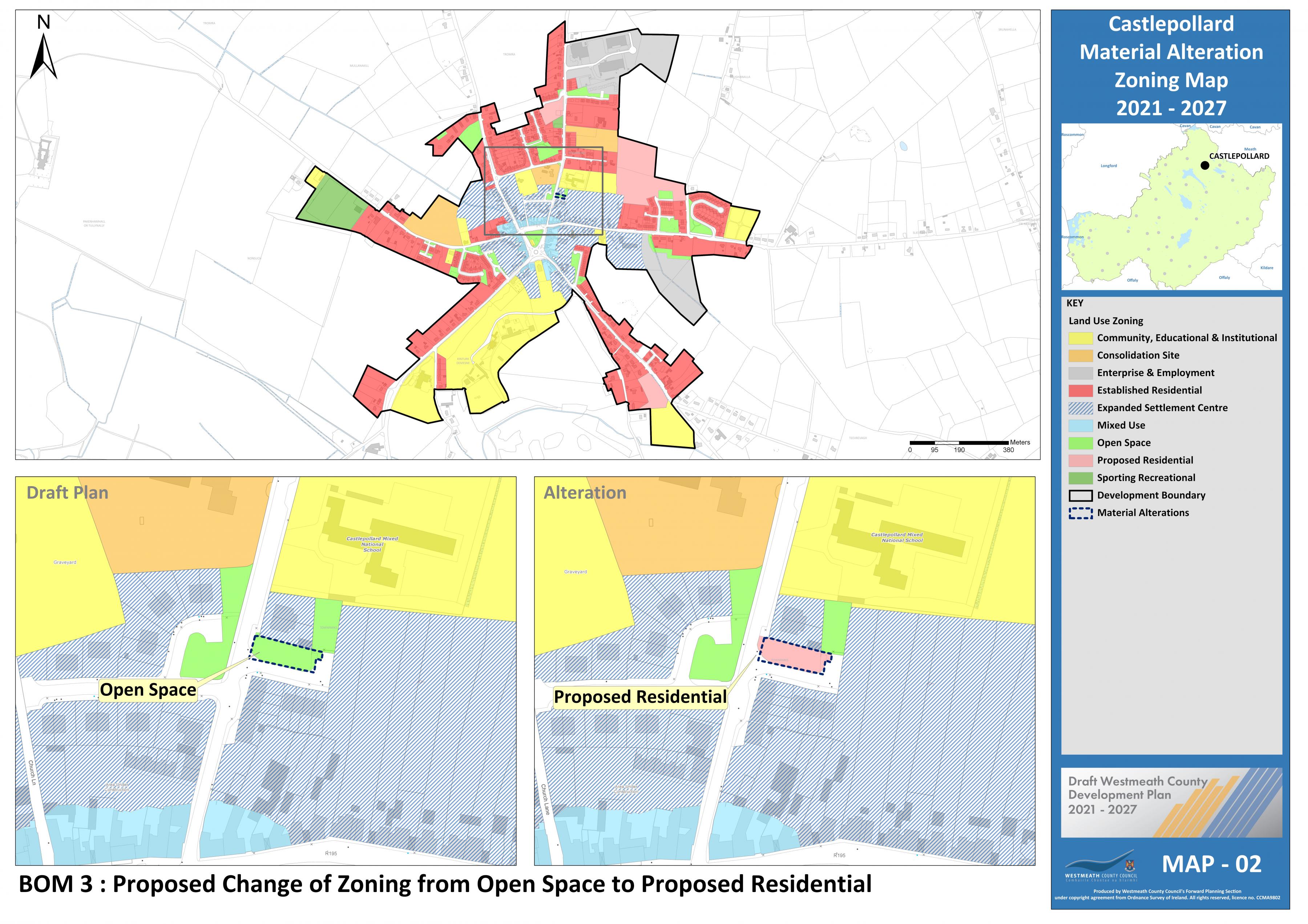
Proposed Amendment BOM 3 |
|
|
Title |
Map No. |
|
Castlepollard Zoning |
2 |
Change zoning from unzoned to “Proposed residential”
|
Proposed Amendment BOM 4 |
|
|
Title |
Map No. |
|
Castlepollard Objective |
3 |

Insert new CPO for Castlepollard under section 8.3.1.6 of the plan as follows:
Development proposals on identified lands shall be accompanied by a site-specific Flood Risk Assessment (FRA) carried out in accordance with the methodology set out in ‘The Planning System and Flood Risk Management – Guidelines for Planning Authorities, 2009’ (See Map 3 MBLO CP 1-4).
|
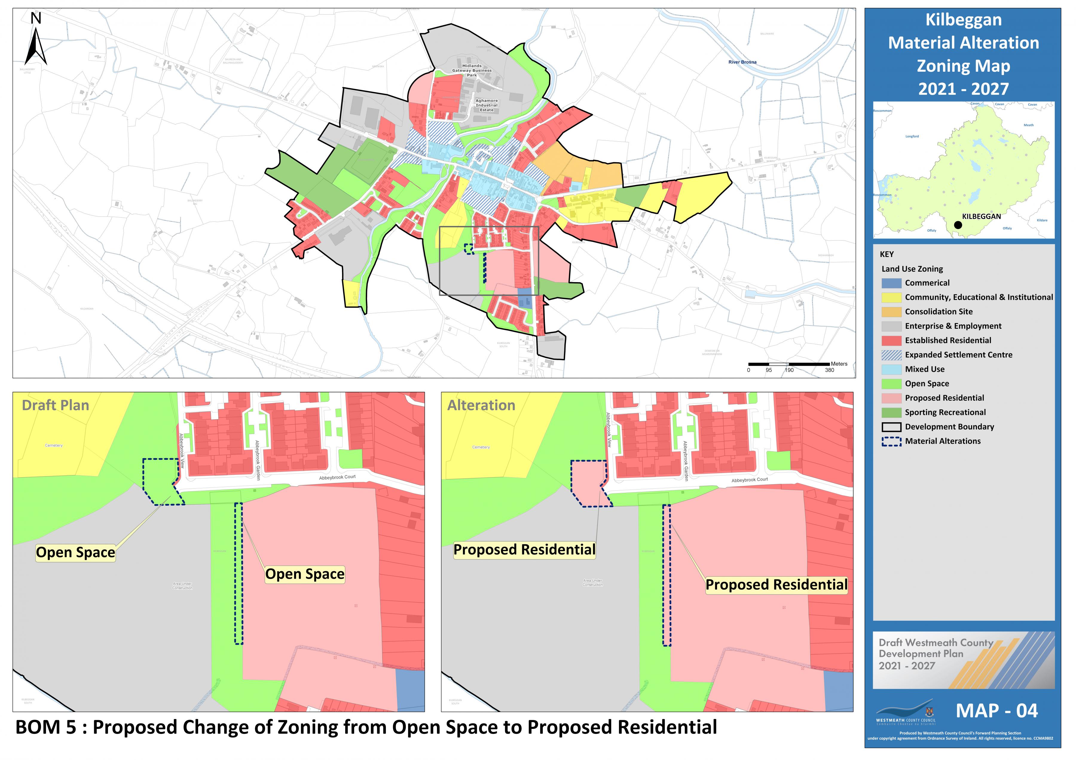
Proposed Amendment BOM 5 |
|
|
Title |
Map No. |
|
Kilbeggan Zoning |
4 |
Change zoning from “Open Space” to “Proposed Residential”.
|
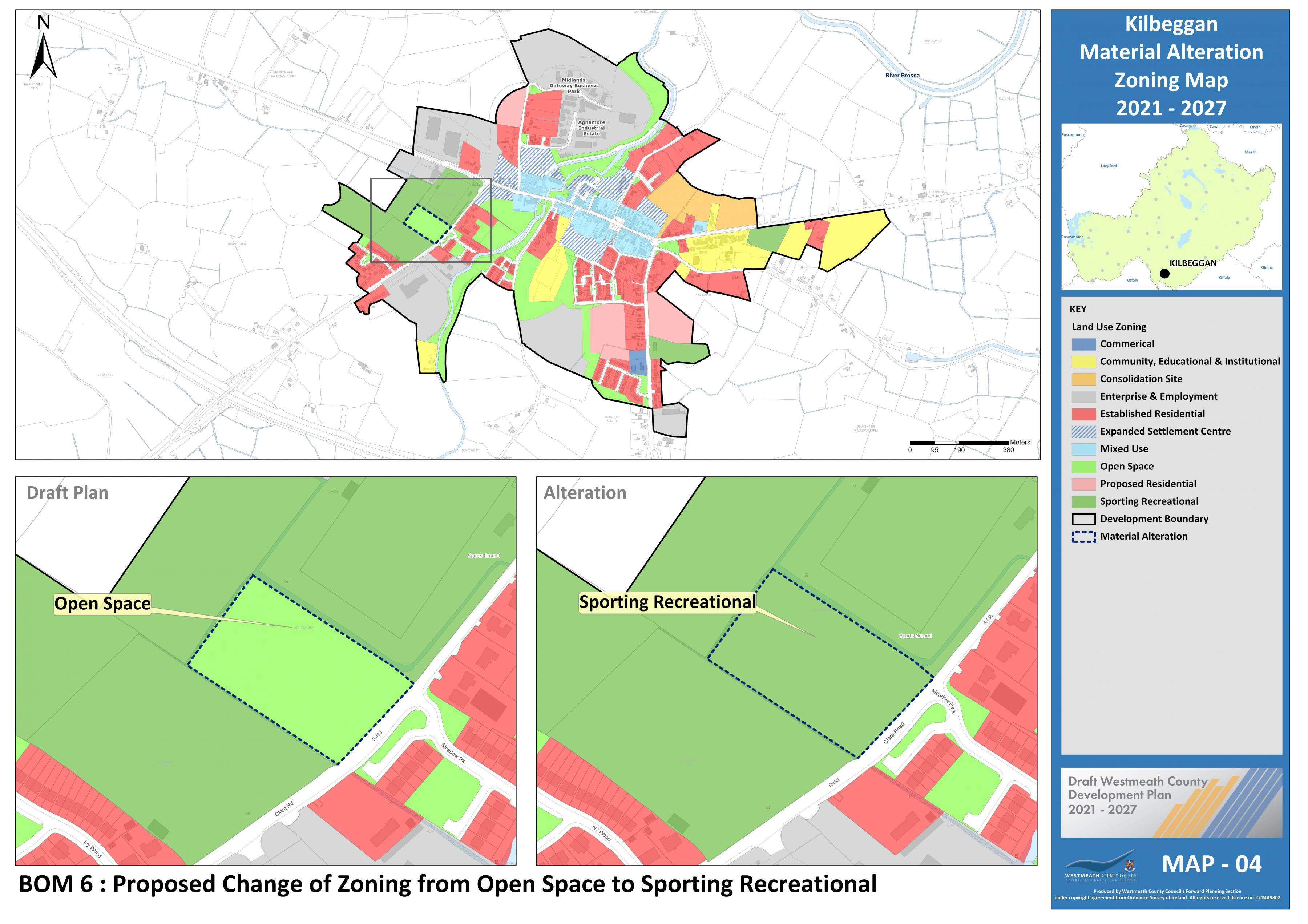
Proposed Amendment BOM 6 |
|
|
Title |
Map No. |
|
Kilbeggan Zoning |
4 |
Change zoning from “Open Space” to “Sporting Recreational"
|
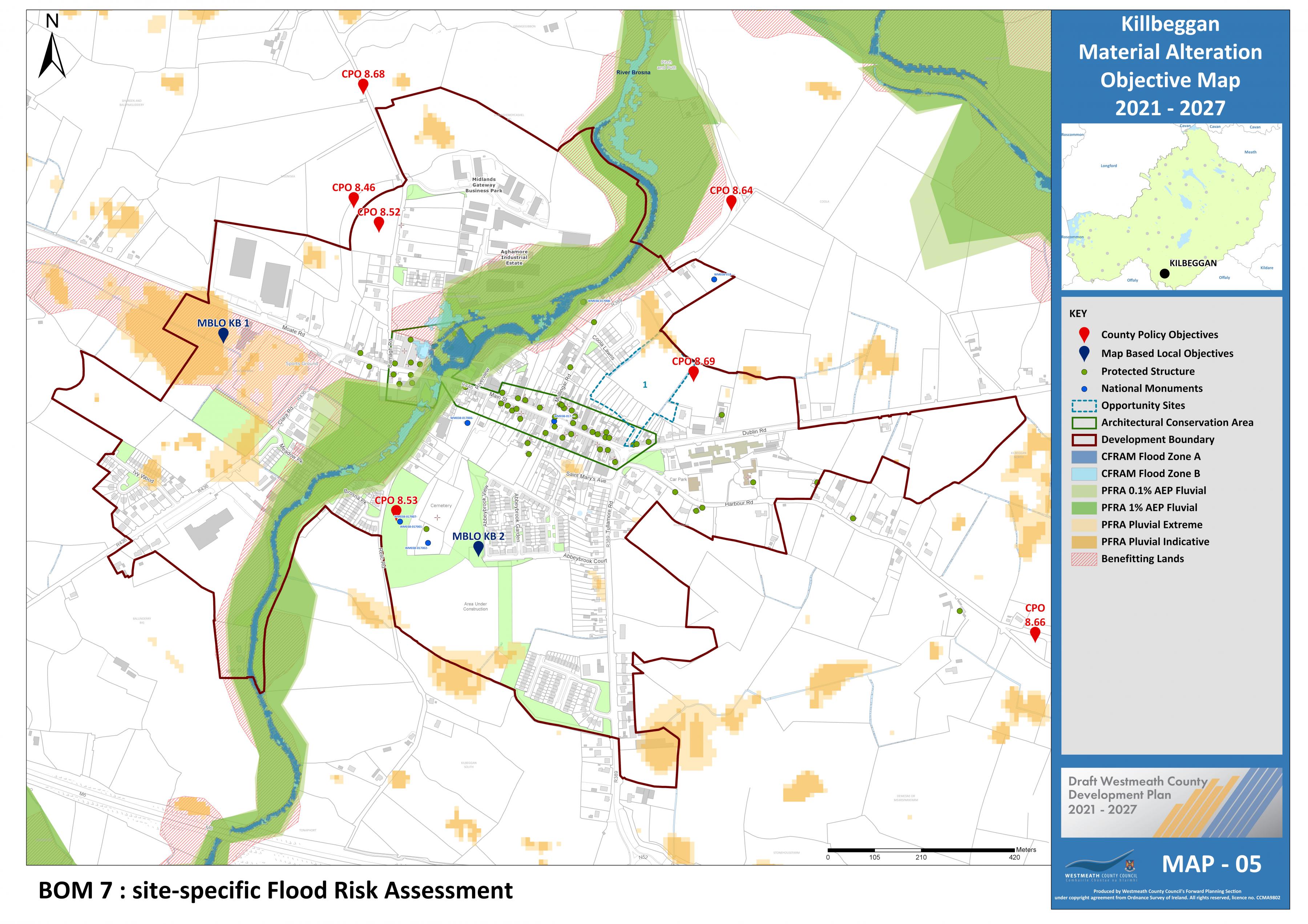
Proposed Amendment BOM 7
|
|
|
Title |
Map No. |
|
Kilbeggan Objective |
5 |
Insert new CPO for Kilbeggan under section 8.3.2.6 of the plan as follows:
Development proposals on identified lands shall be accompanied by a site-specific Flood Risk Assessment (FRA) carried out in accordance with the methodology set out in ‘The Planning System and Flood Risk Management – Guidelines for Planning Authorities, 2009’ (See Map 5 MBLO KB 1).
|
Proposed Amendment BOM 8 |
|
|
Title |
Map No. |
|
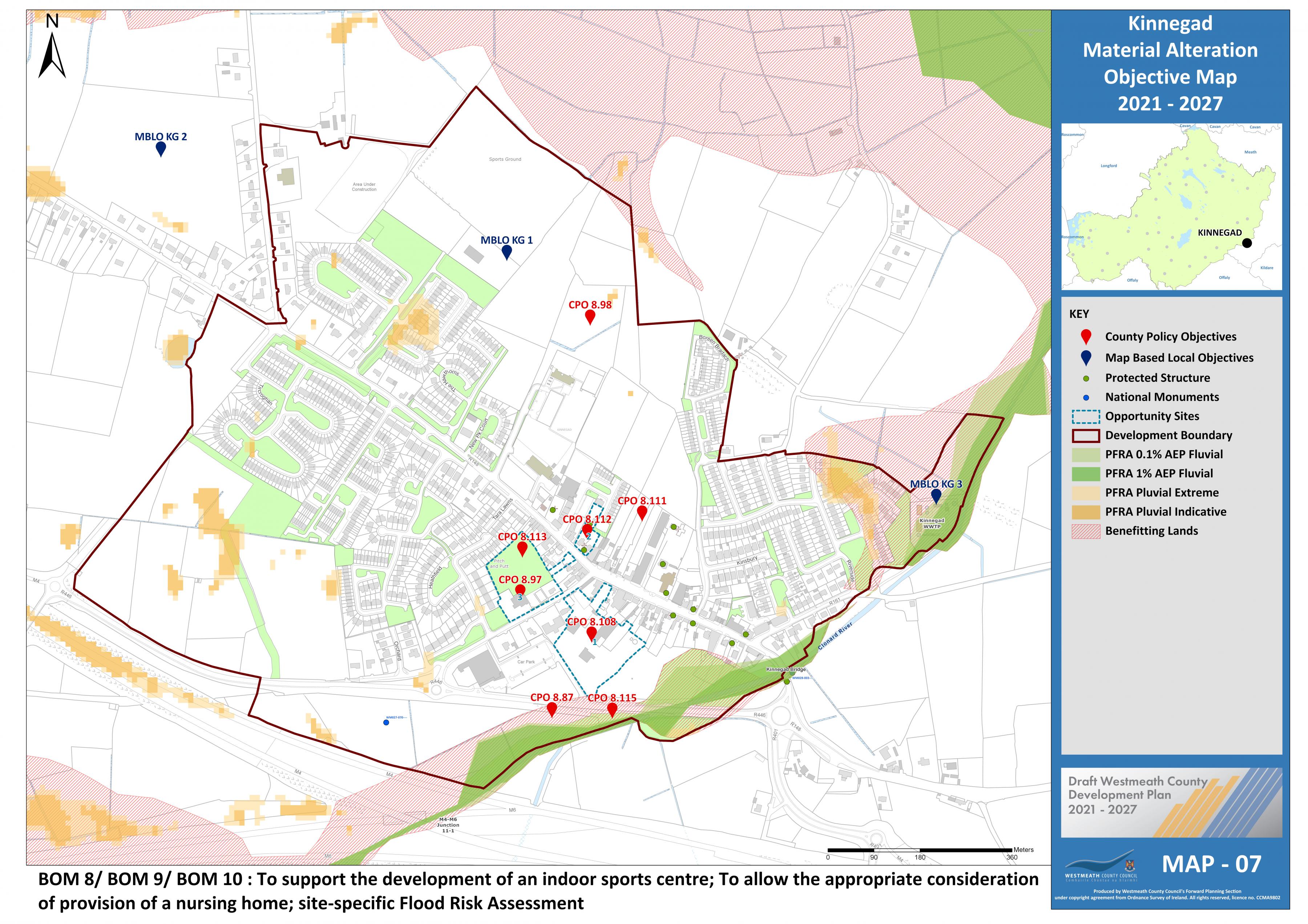
Kinnegad Objective |
7 |
Insert new map-based objective after CPO
|
Proposed Amendment BOM 9 |
|
|
Title |
Map No. |
|
Kinnegad Objective |
7 |
Insert new CPO after CPO 8.97 as follows;
To support the development of an indoor sports centre and meeting rooms at Coralstown Kinnegad GAA in conjunction with all the voluntary and sporting groups in the area (See Map 7 MBLO KG 1).
|
Proposed Amendment BOM 10 |
|
|
Title |
Map No. |
|
Kinnegad Objective |
7 |
Insert new CPO for Kinnegad under section 8.3.3.7 of the plan as follows:
Development proposals on identified lands shall be accompanied by a site-specific Flood Risk Assessment (FRA) carried out in accordance with the methodology set out in ‘The Planning System and Flood Risk Management – Guidelines for Planning Authorities, 2009’ (See Map 7 MBLO KG 3).
|
Proposed Amendment BOM 11 |
|
|
Title |
Map No. |
|
Moate Zoning |
8 |
Change zoning from “Open Space” to “Proposed residential”
|
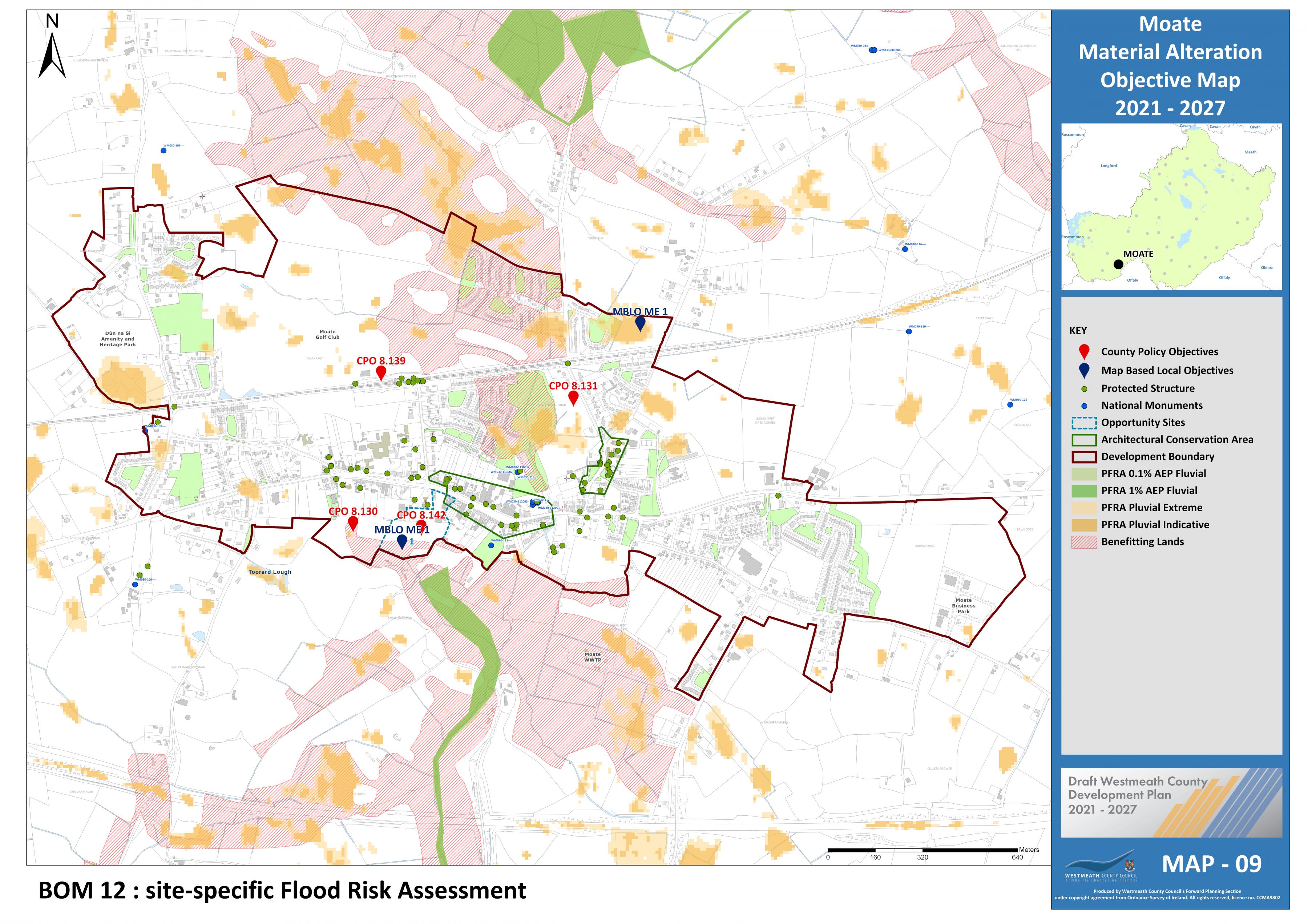
Proposed Amendment BOM 12 |
|
|
Title |
Map No. |
|
Moate Objective |
9 |
Insert new CPO for Moate under section 8.3.4.6 of the plan as follows:
Development proposals on identified lands shall be accompanied by a site-specific Flood Risk Assessment (FRA) carried out in accordance with the methodology set out in ‘The Planning System and Flood Risk Management – Guidelines for Planning Authorities, 2009’ (See Map 9 MBLO ME 1).
|
Proposed Amendment BOM 13 |
|
|
Title |
Map No. |
|
Killucan Rathwire Zoning |
10 |
Change zoning from unzoned to “Proposed residential”

|
Proposed Amendment BOM 14 |
|
|
Title |
Map No. |
|
Killucan Rathwire Zoning |
10 |
Change zoning from “Open Space” to “Proposed residential”

|
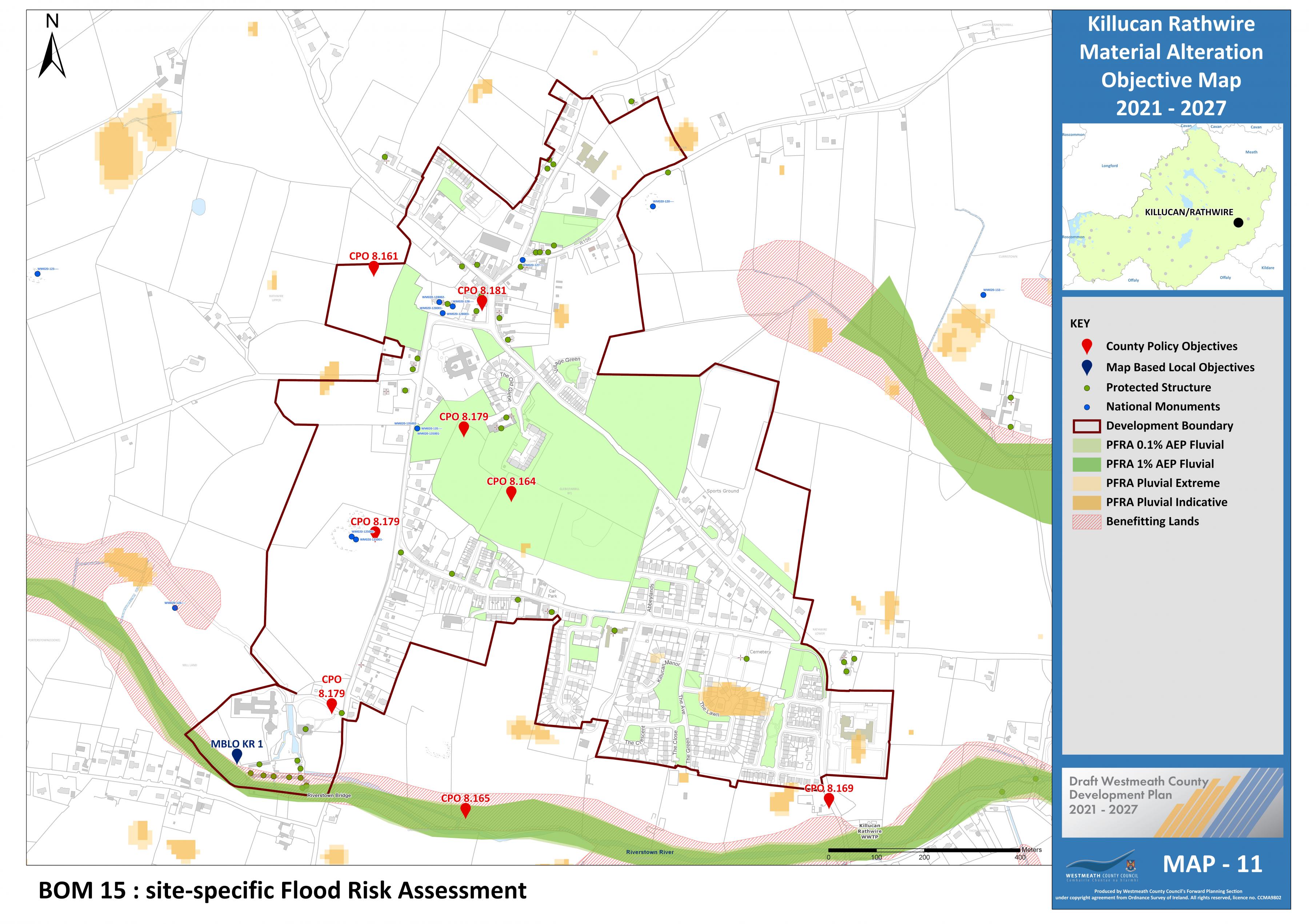
Proposed Amendment BOM 15 |
|
|
Title |
Map No. |
|
Killucan Rathwire Objective |
11 |
Insert new CPO for Killucan-Rathwire under section 8.4.1.6 of the plan as follows:
Development proposals on identified lands shall be accompanied by a site-specific Flood Risk Assessment (FRA) carried out in accordance with the methodology set out in ‘The Planning System and Flood Risk Management – Guidelines for Planning Authorities, 2009’ (See Map 11 MBLO KR 1).
|
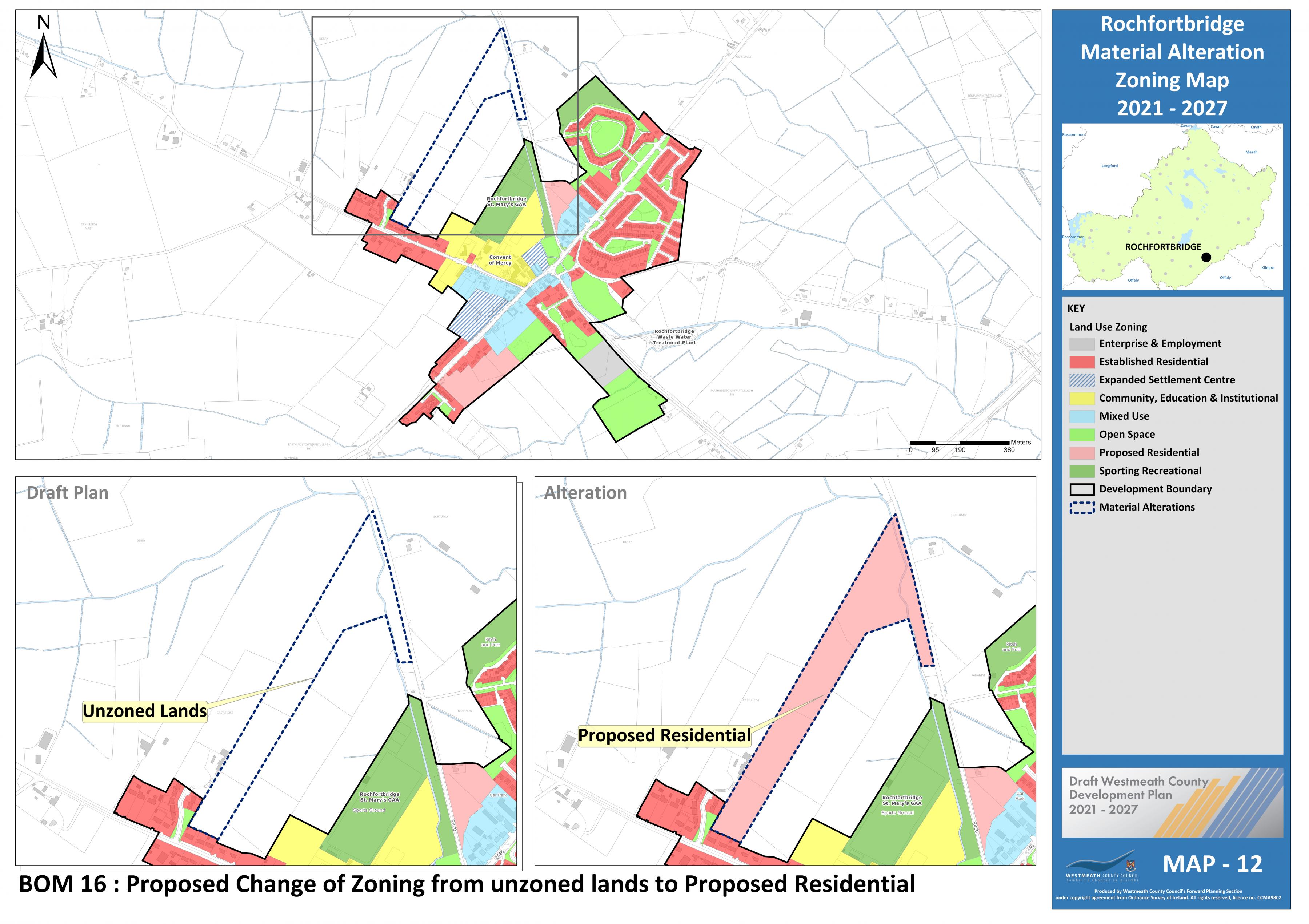
Proposed Amendment BOM 16
|
|
|
Title |
Map No. |
|
Rochfortbridge Zoning |
12 |
Change zoning from unzoned to “Proposed residential”
|
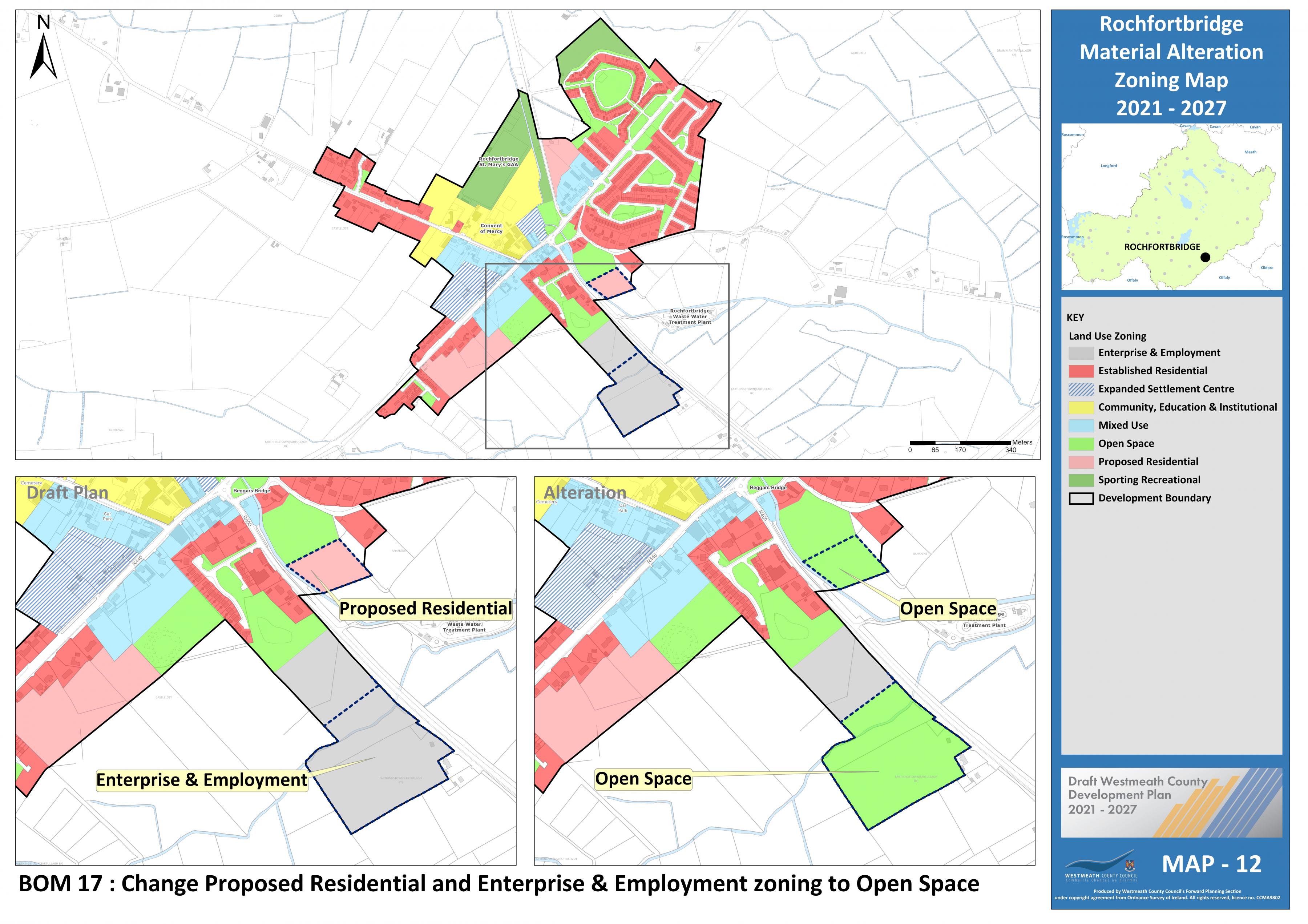
Proposed Amendment BOM 17 |
|
|
Title |
Map No. |
|
Rochfortbridge Zoning |
12 |
Change “Proposed Residential” and “Enterprise and Employment” zoning to “Open Space”
|
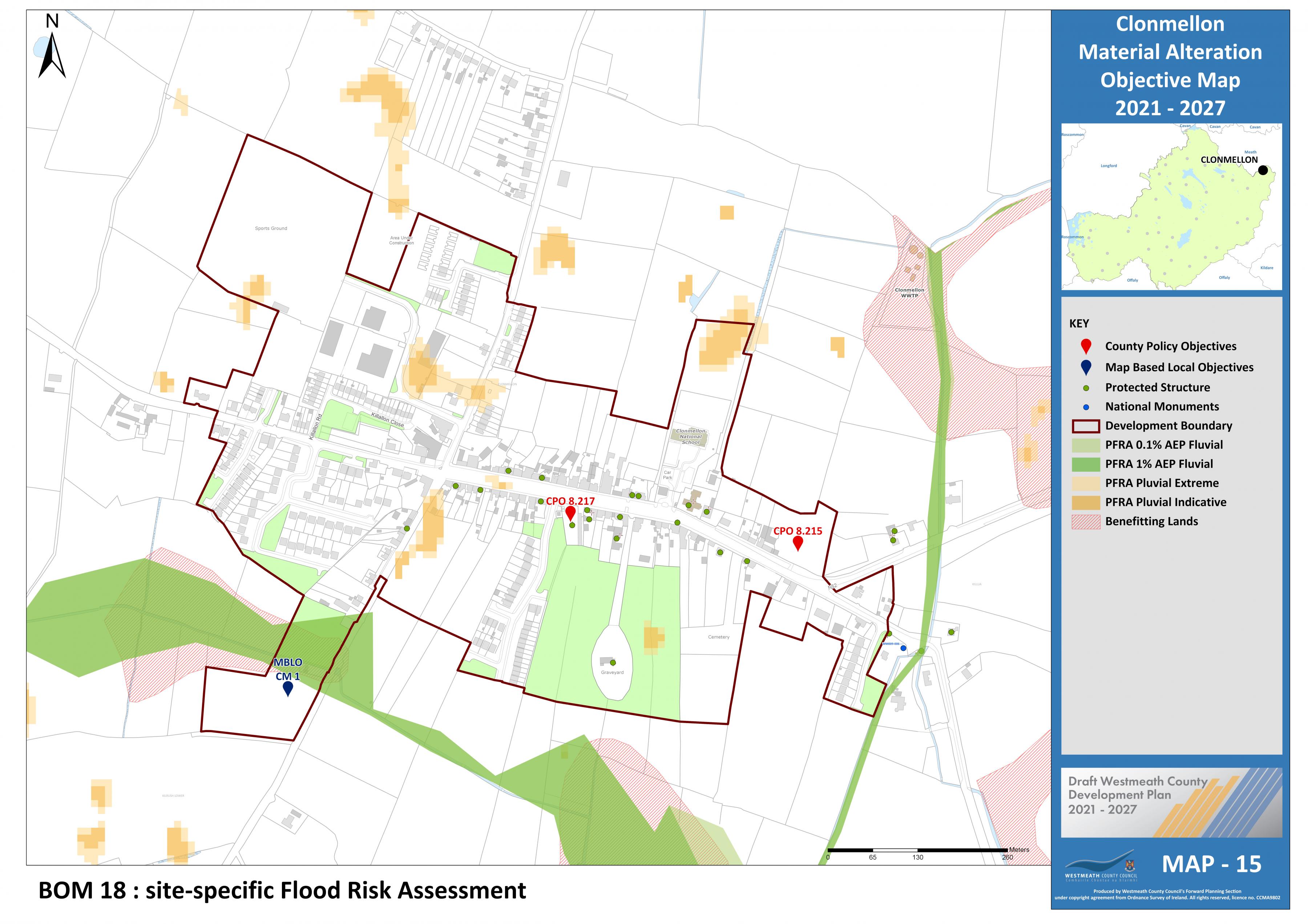
Proposed Amendment BOM 18 |
|
|
Title |
Map No. |
|
Clonmellon Objective |
15 |
Insert new CPO for Clonmellon under section 8.5.1.7 of the plan as follows:
Development proposals on identified lands shall be accompanied by a site-specific Flood Risk Assessment (FRA) carried out in accordance with the methodology set out in ‘The Planning System and Flood Risk Management – Guidelines for Planning Authorities, 2009’ (See Map 15 MBLO CM 1)
|
Proposed Amendment BOM 19
|
|
|
Title |
Map No. |
|
Delvin Zoning |
16 |
Change zoning from unzoned to “Proposed residential” and from “Proposed Residential to unzoned.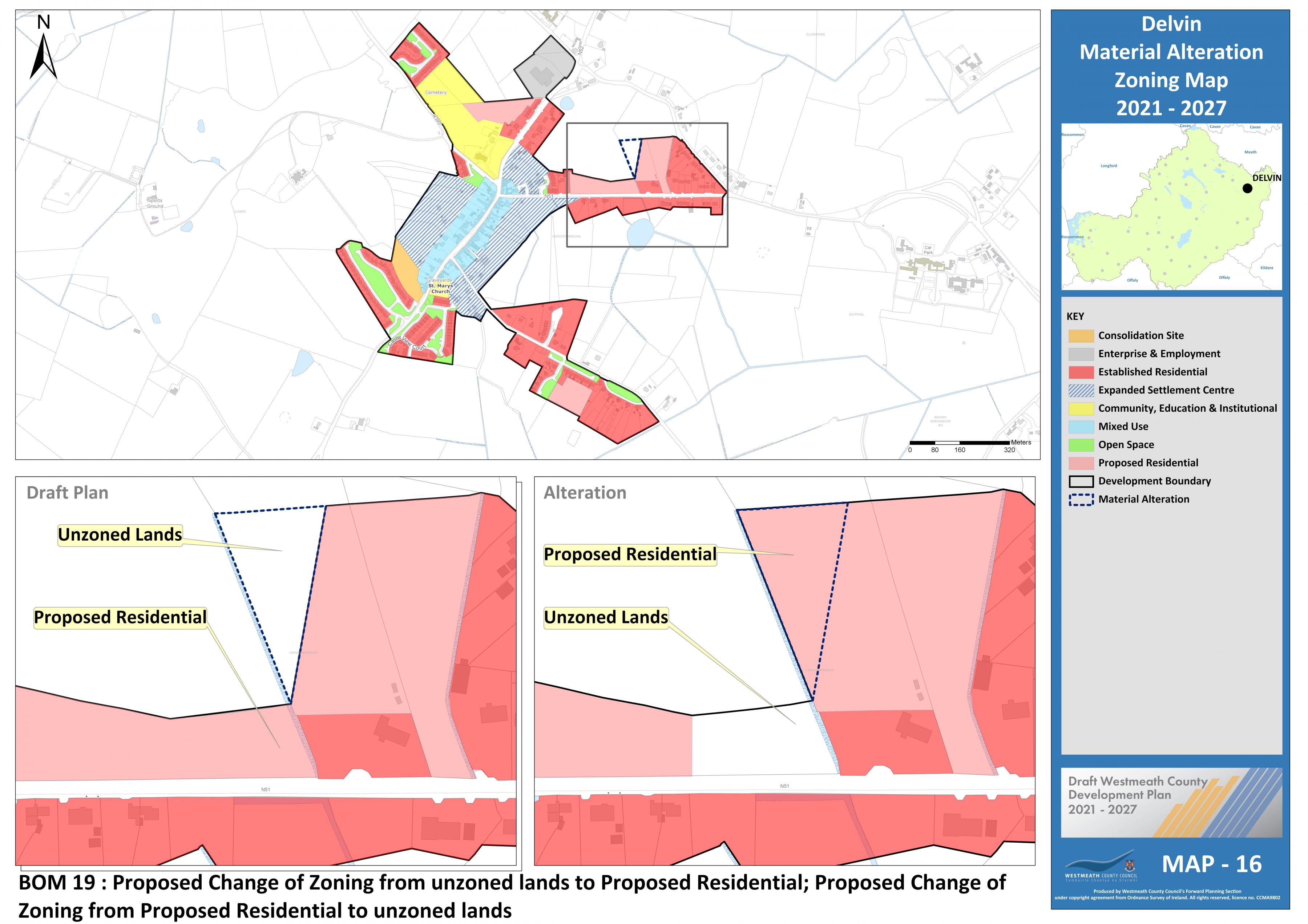
|
Proposed Amendment BOM 20 |
|
|
Title |
Map No. |
|
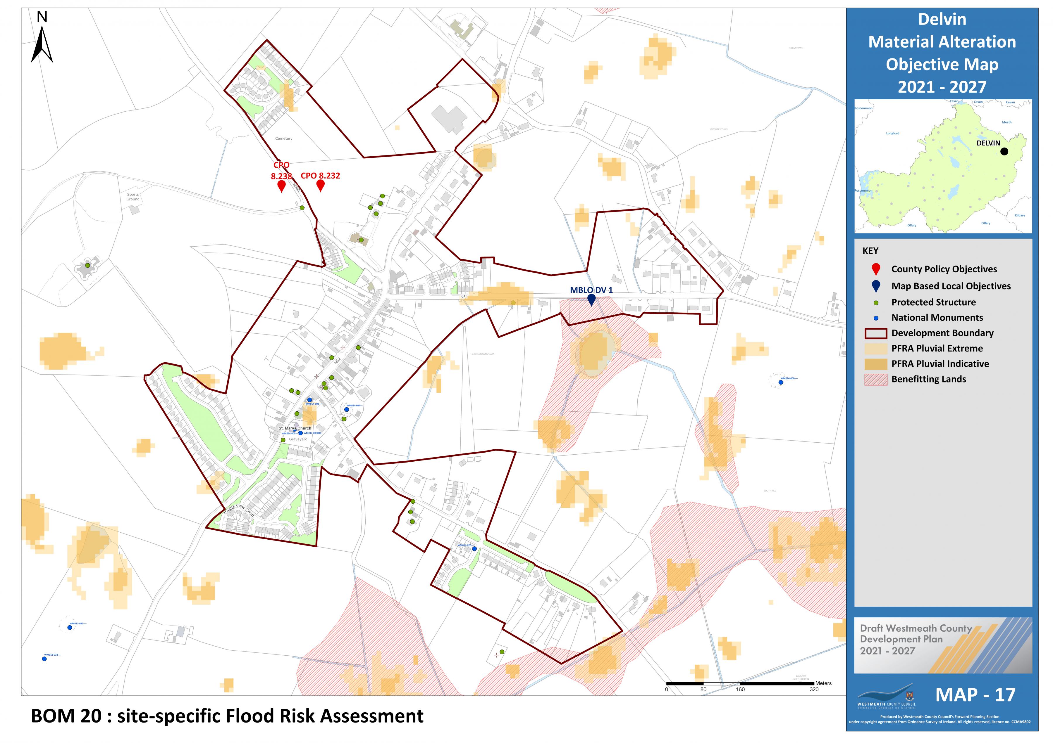
Delvin Objective |
17 |
Insert new CPO for Delvin under section 8.5.2.5 of the plan as follows:
Development proposals on identified lands shall be accompanied by a site-specific Flood Risk Assessment (FRA) carried out in accordance with the methodology set out in ‘The Planning System and Flood Risk Management – Guidelines for Planning Authorities, 2009’ (See Map 17 MBLO DV 1).
|
Proposed Amendment BOM 21 |
|
|
Title |
Map No. |
|
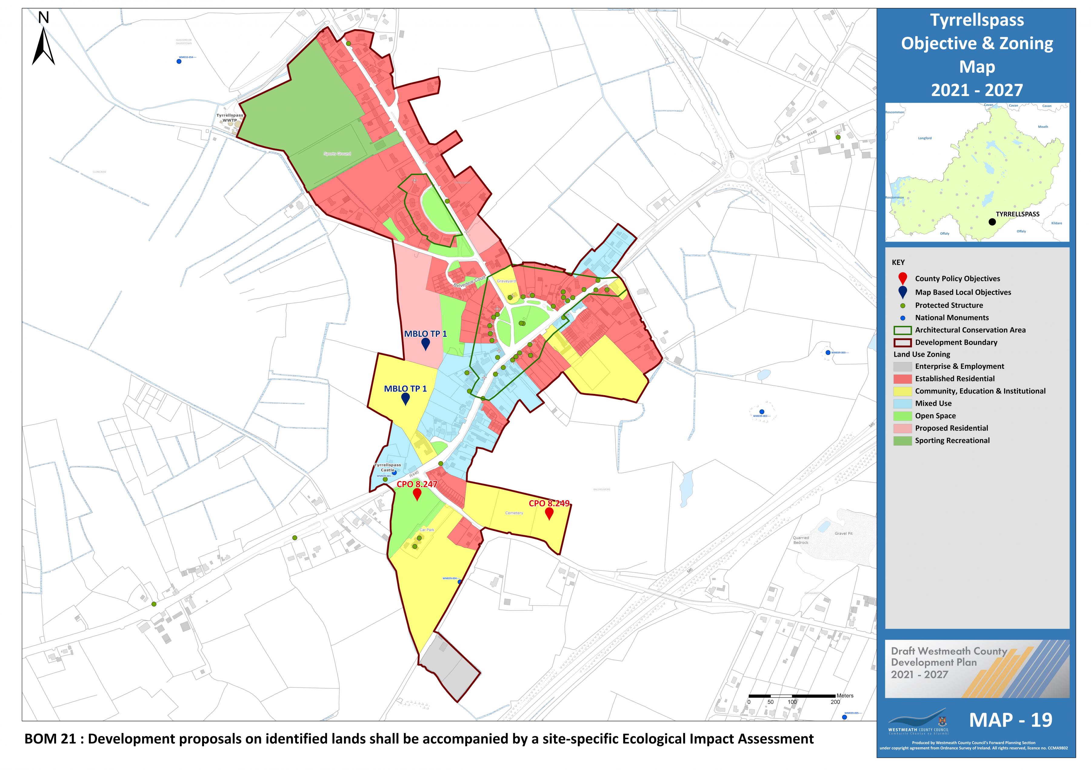
Tyrrellspass Zoning |
19 |
Insert new CPO after CPO 8.249 of the plan as follows:
Any proposal for development at these lands shall be accompanied by an Ecological Impact Assessment that considers ecological sensitivities, including those relating to the nearby Cloncrow Bog NHA, and the proposed design of any development. The Ecological Impact Assessment shall demonstrate the compliance of the proposal with the provisions of the Plan relating to biodiversity and flora and fauna; and that the NHA will not be adversely affected by the proposed development (See Map 19 MBLO TP 1).
|
Proposed Amendment BOM 22 |
|
|
Title |
Map No. |
|
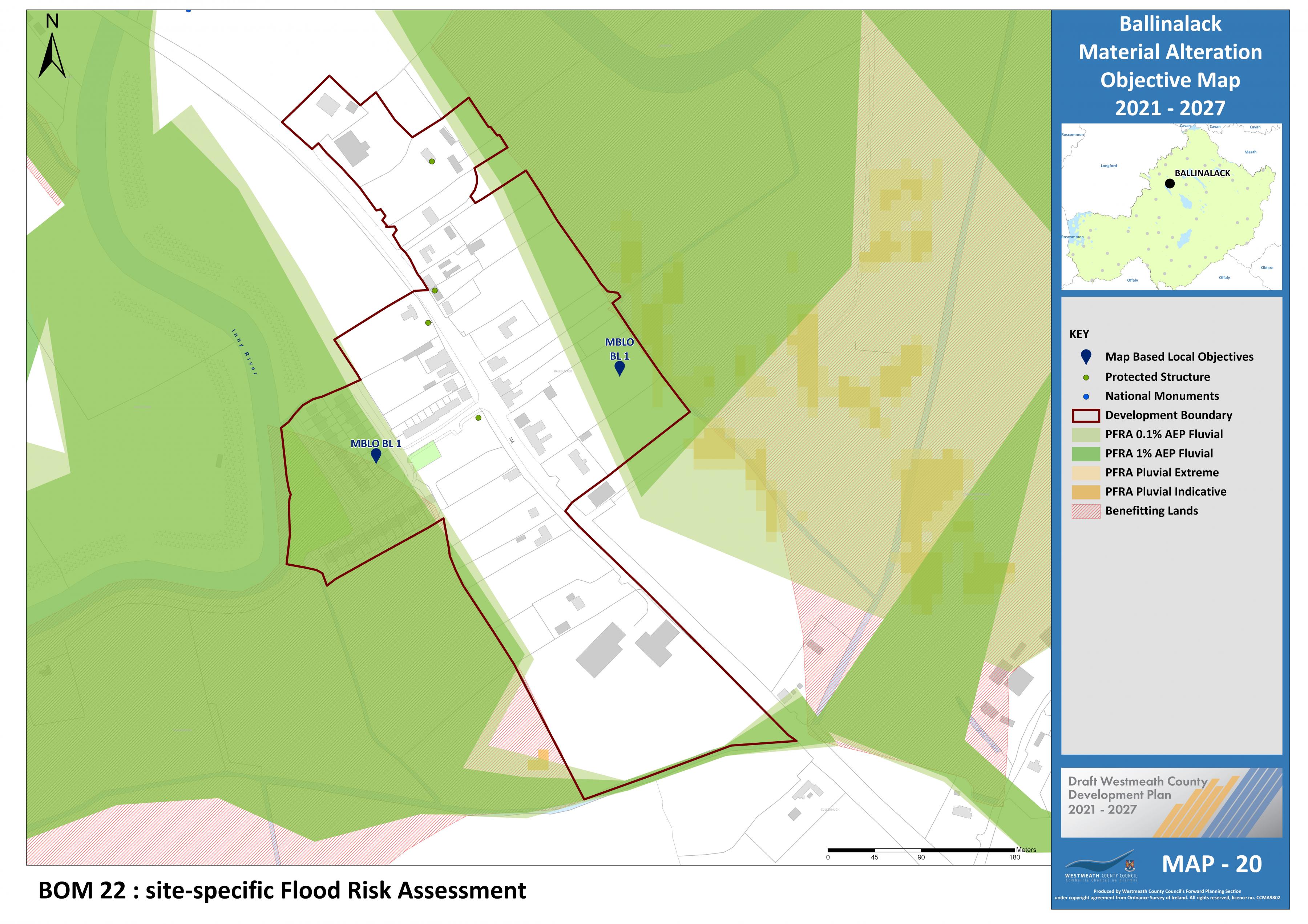
Ballinalack Objective |
20 |
Insert new policy objective for Ballinalack under section 8.6.1 of the plan as follows:
Development proposals on identified lands shall be accompanied by a site-specific Flood Risk Assessment (FRA) carried out in accordance with the methodology set out in ‘The Planning System and Flood Risk Management – Guidelines for Planning Authorities, 2009’ (See Map 20 MBLO BL 1).
|
Proposed Amendment BOM 23 |
|
|
Title |
Map No. |
|
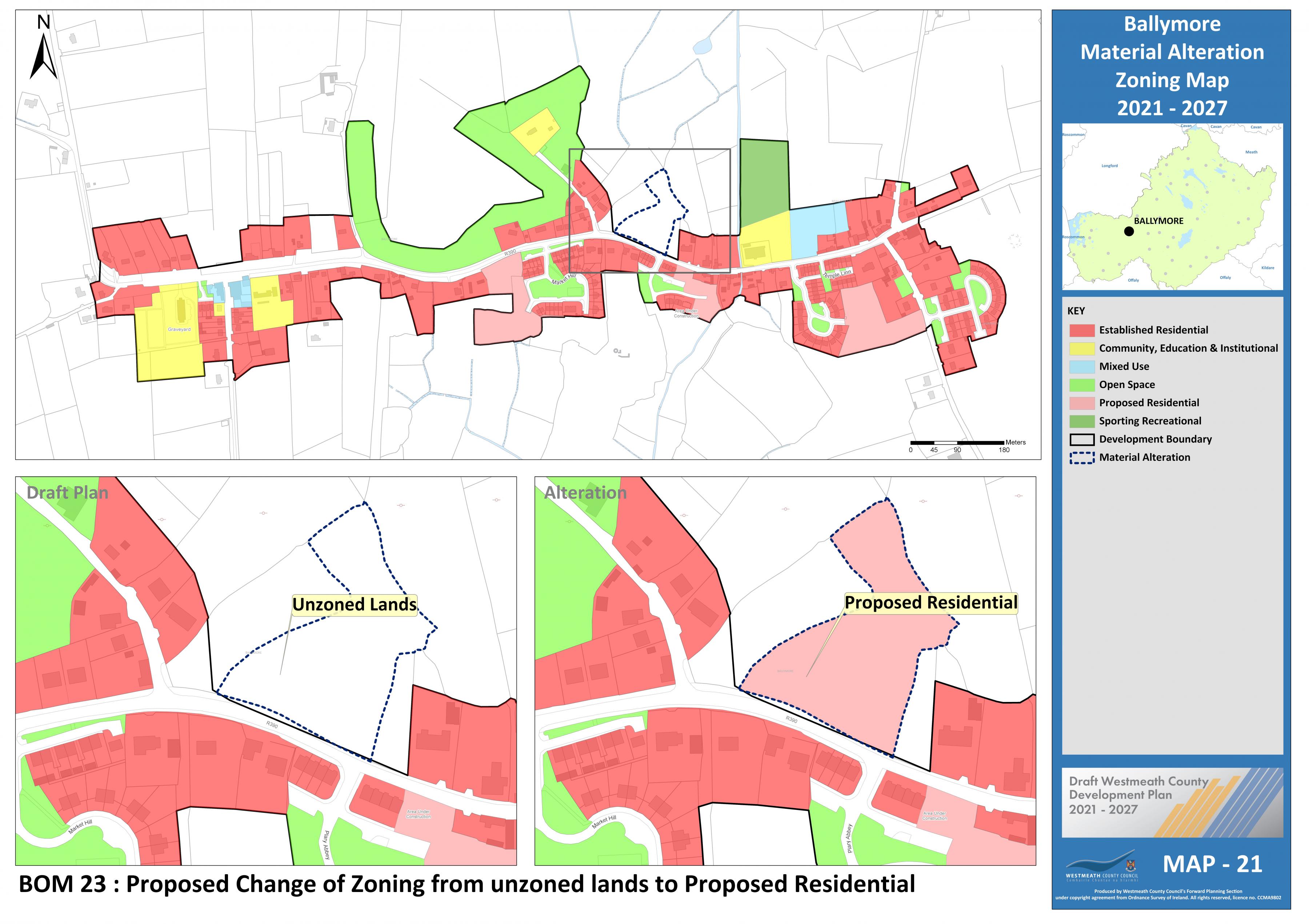
Ballymore Zoning |
21 |
Change zoning from unzoned to “Proposed residential”.
|
Proposed Amendment BOM 24 |
|
|
Title |
Map No. |
|
Ballymore Objective |
21 |
Insert new policy objective for Ballymore under section 8.6.2 of the plan as follows:
Development proposals on identified lands shall be accompanied by a site-specific Flood Risk Assessment (FRA) carried out in accordance with the methodology set out in ‘The Planning System and Flood Risk Management – Guidelines for Planning Authorities, 2009’ (See Map 21 MBLO BM 1).

|
Proposed Amendment BOM 25 |
|
|
Title |
Map No. |
|
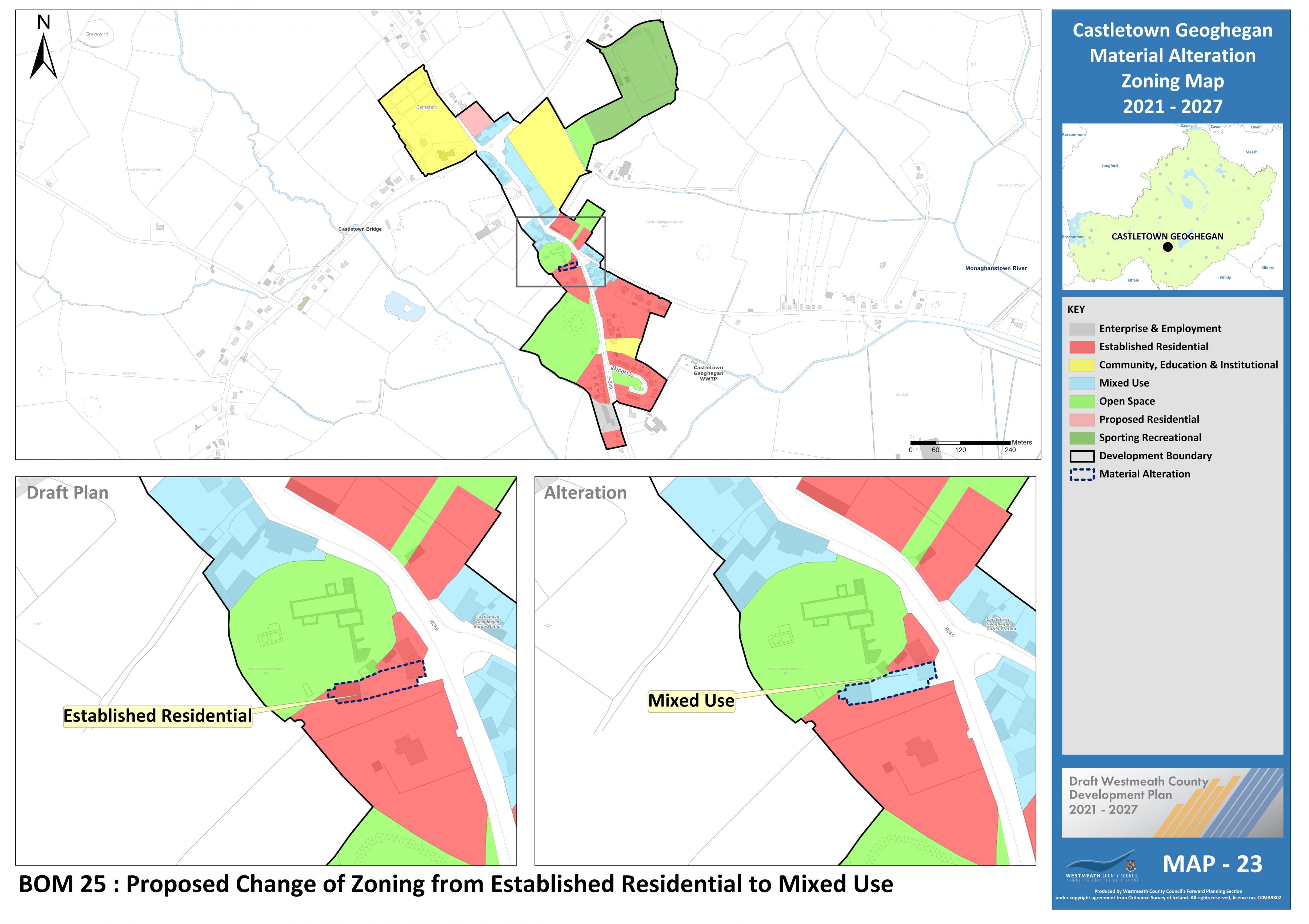
Castletown Geoghegan Zoning |
23 |
Change zoning from “Established Residential” to “Mixed Use”.
|
Proposed Amendment BOM 26 |
|
|
Title |
Map No. |
|
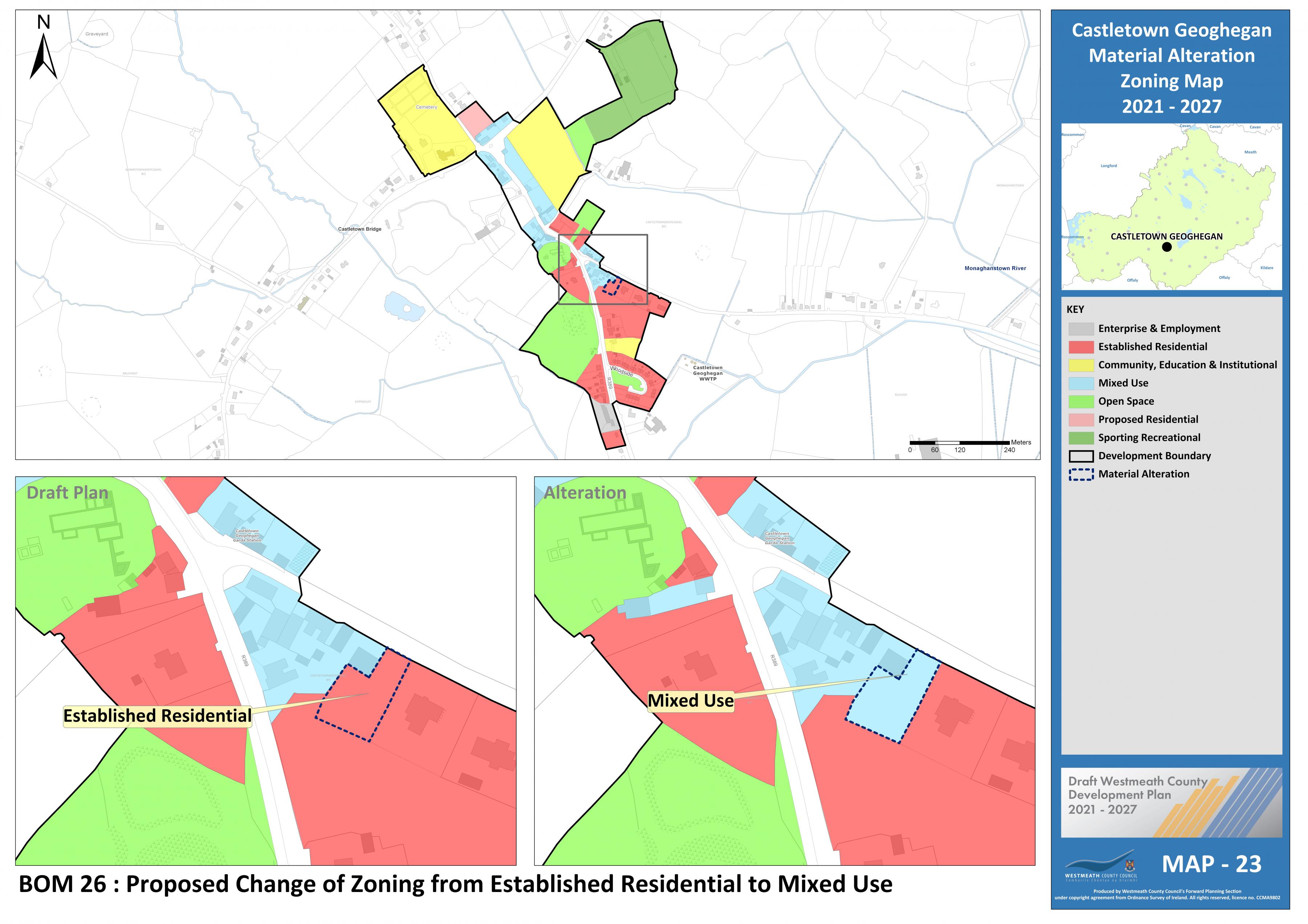
Castletown Geoghegan Zoning |
23 |
Change zoning from “Established Residential” to “Mixed Use”.
|
Proposed Amendment BOM 27 |
|
|
Title |
Map No. |
|
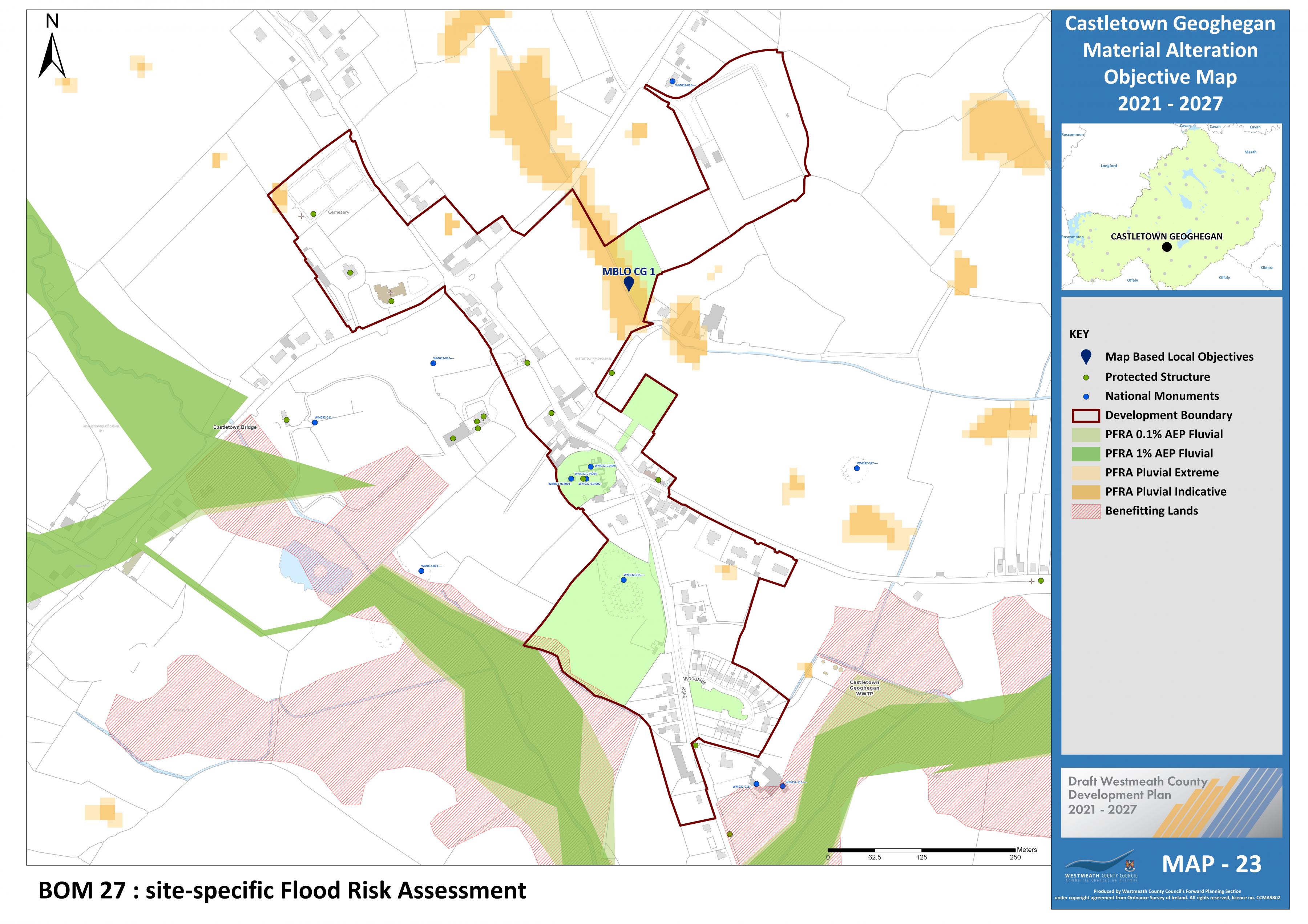
Castletown Geoghegan Objective |
23 |
Insert new policy objective for Castletown Geoghegan under section 8.6.4 of the plan as follows:
Development proposals on identified lands shall be accompanied by a site-specific Flood Risk Assessment (FRA) carried out in accordance with the methodology set out in ‘The Planning System and Flood Risk Management – Guidelines for Planning Authorities, 2009’ (See Map 23 MBLO CG 1).
|
Proposed Amendment BOM 28 |
|
|
Title |
Map No. |
|
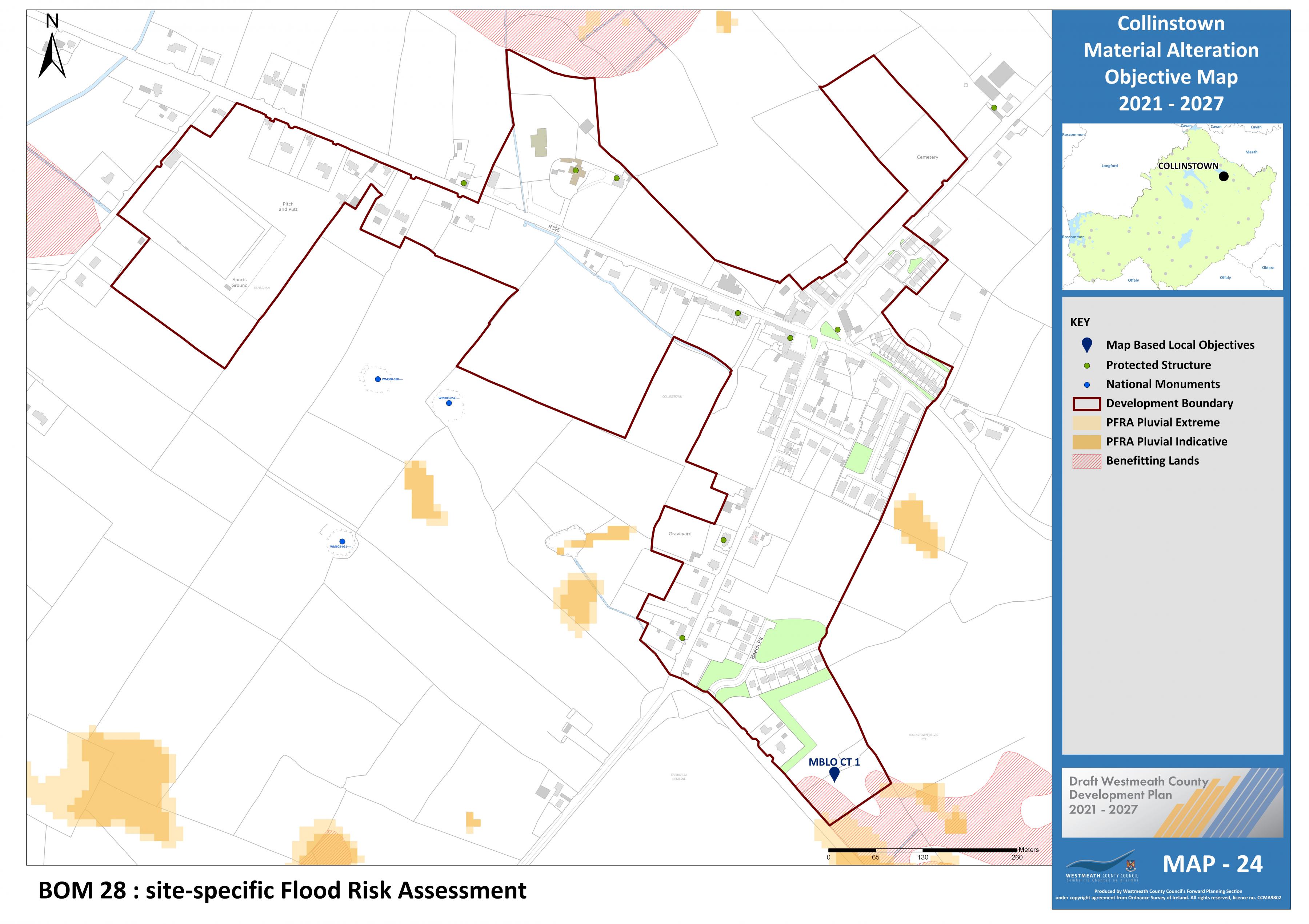
Collinstown Objective |
24 |
Insert new policy objective for Collinstown under section 8.6.5 of the plan as follows:
Development proposals on identified lands shall be accompanied by a site-specific Flood Risk Assessment (FRA) carried out in accordance with the methodology set out in ‘The Planning System and Flood Risk Management – Guidelines for Planning Authorities, 2009’ (See Map 24 MBLO CT 1).
|
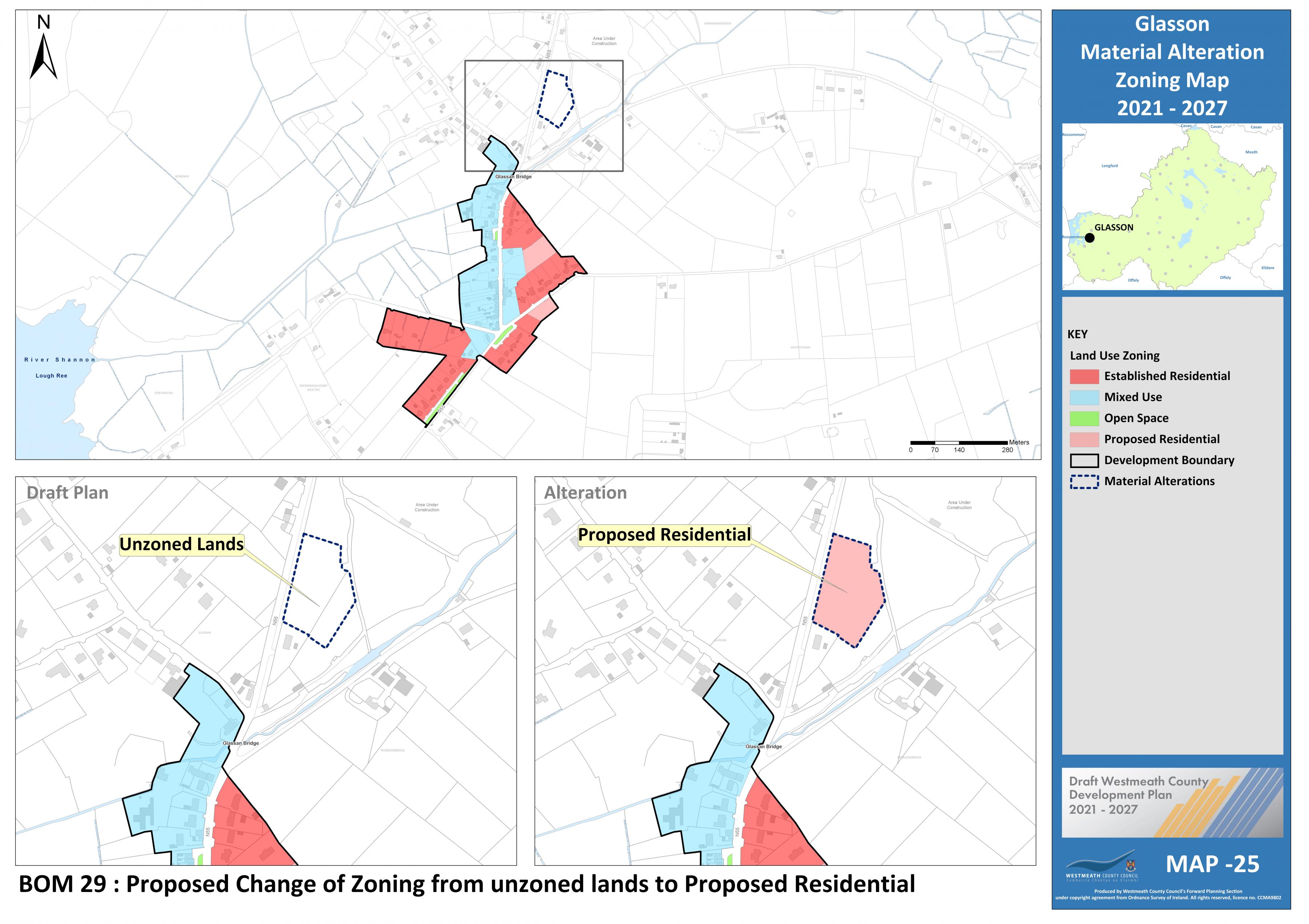
Proposed Amendment BOM 29 |
|
|
Title |
Map No. |
|
Glasson Zoning |
25 |
Change zoning from unzoned to “Proposed Residential”
|
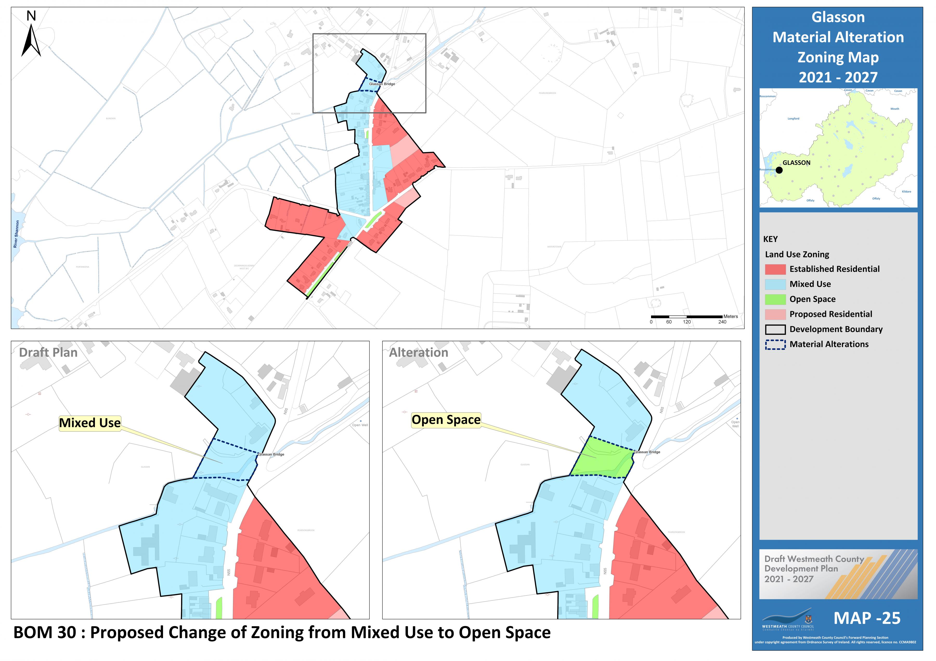
Proposed Amendment BOM 30 |
|
|
Title |
Map No. |
|
Glasson Zoning |
25 |
Change zoning from “Mixed Use” to “Open Space”.
|
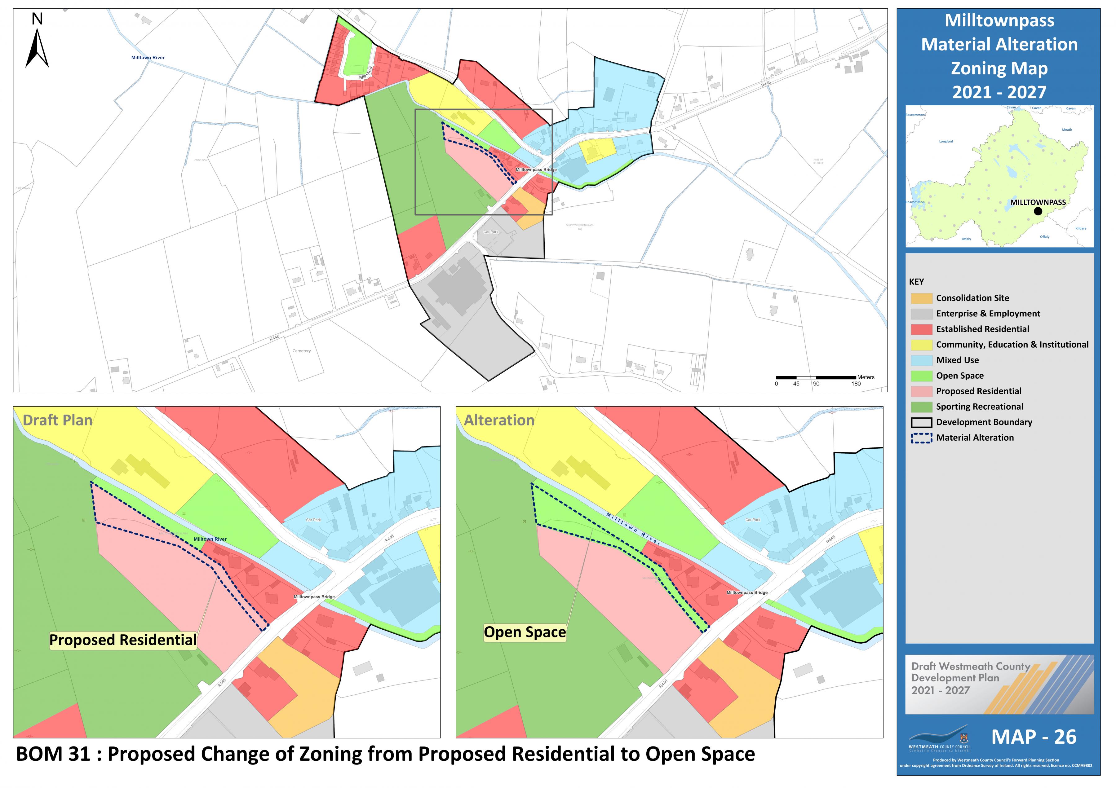
Proposed Amendment BOM 31 |
|
|
Title |
Map No. |
|
Milltownpass Zoning |
26 |
Change zoning from “Proposed Residential” to “Open Space”.
|
Proposed Amendment BOM 32 |
|
|
Title |
Map No. |
|
Multyfarnham Zoning |
27 |

Change zoning from “Open Space” to “Established Residential”
|
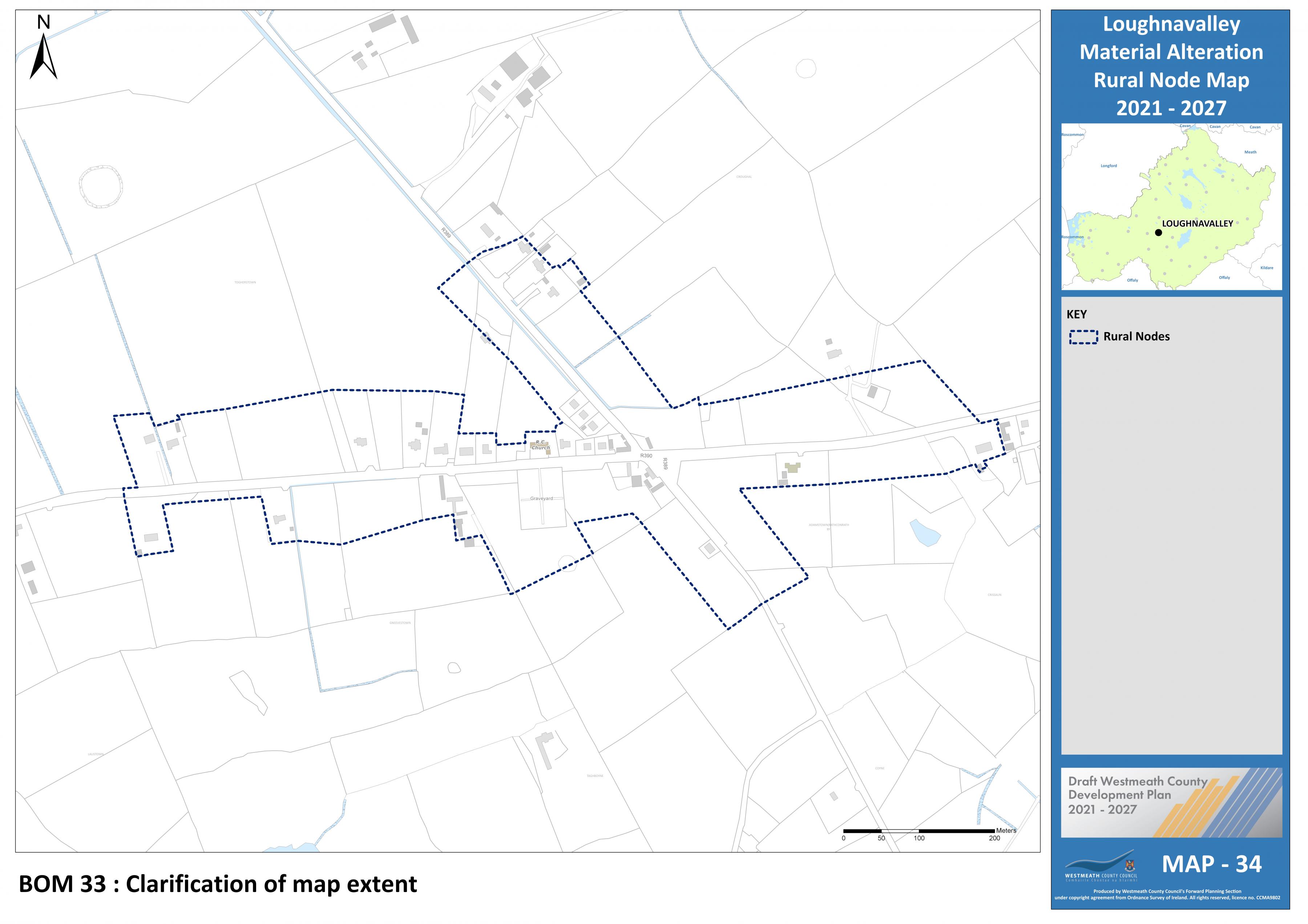
Proposed Amendment BOM 33 |
|
|
Title |
Map No. |
|
Loughnavalley Node |
34 |
Include Map boundary for clarification purposes.
|
Proposed Amendment BOM 34 |
|
|
Title |
Map No. |
|
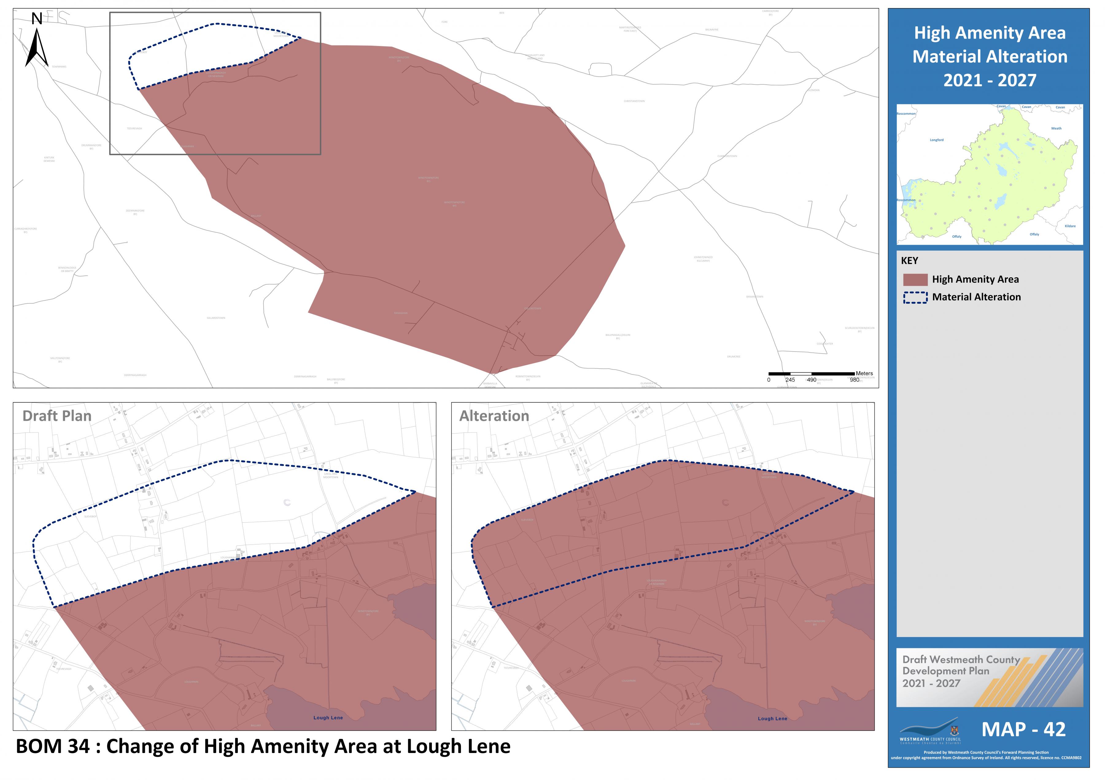
High Amenity Area |
42 |
Include previously omitted lands as part of Lough Lene High Amenity Area.
|
Proposed Amendment BOM 35
|
|
|
Title |
Map No. |
|
High Amenity Area |
42 |
Include previously omitted lands as part of Lough Derravaragh High Amenity Area.

|
Proposed Amendment BOM 36 |
|
|
Title |
Map No. |
|
Wind Energy Capacity |
48 |
Designate Area 7 as Low wind energy capacity –

Area 7 identified in orange and classified as medium capacity.
Contents
Materials
References
Observations
Observations
Volume 2 Book of Maps:
Proposed Amendment BOM 21, Tyrrellspass Zoning Map N. 19
The Department acknowledges the inclusion of the new CPO, following our recommendations, after CPO 8....
Administrative Officer,
Westmeath Co. Dev Planning
Planning Department,
Westmeath County Council,
Áras an Chontae,
Mount Street,
Mullingar
Westmeath County...
Administrative Officer,
Westmeath Co. Dev Planning
Planning Department,
Westmeath County Council,
Áras an Chontae,
Mount Street,
Mullingar
Westmeath County...
We Feel that there should be more ground zoned Residential and we offer amenity area which is already zoned in our lands