

Please see attached submission
Cllr. Louise Heavin
Chairperson Westmeath Heritage Forum
12. Natural Heritage and Green Infrastructure
Closed28 Feb, 2020, 1:00pm - 30 Jun, 2020, 5:00pm
12.1 Introduction
Aim: Continue to protect and enhance the County’s natural heritage and biodiversity and ensure that networks of green infrastructure are identified, created, protected and enhanced to provide a wide range of environmental, social and economic benefits to communities.
12.2 Natural Heritage and Green Infrastructure
Westmeath supports a wide range of habitat types and landscapes including peatlands, lakes, canals, woodlands, wetlands, grasslands, eskers and hedgerows. Natural heritage and biodiversity are integral to the image of Westmeath and contribute to the well-being and quality of life of those living in and visiting the County. It is recognised that green infrastructure is an innovative approach to the maintenance and preservation of biodiversity and ecosystem services in the wider landscape. The plan supports the development of green infrastructure networks in order to protect the county’s rich and varied natural heritage.
12.3 Natural Heritage Policy Framework
This Plan sets out to contribute towards the protection of designated ecological sites including Special Areas of Conservation (SACs) and Special Protection Areas (SPAs), Ramsar Sites, Flora Protection Order Sites, Wildlife Sites (including Nature Reserves), Certain entries to the Water Framework Directive Register of Protected Areas, Natural Heritage Areas (NHAs) and proposed Natural Heritage Areas (pNHAs), Wildfowl Sanctuaries (see S.I. 192 of 1979) and Tree Preservation Orders (TPOs). Contribute towards compliance with relevant EU Environmental Directives and applicable National Legislation, Policies, Plans and Guidelines, including the following and any updated/superseding documents:
- EU Directives, including the Habitats Directive (92/43/EEC, as amended), the Birds Directive (2009/147/EC), the Environmental Liability Directive (2004/35/EC), the Environmental Impact Assessment Directive (2011/92/EU, as amended by 2014/52/EC), the Water Framework Directive (2000/60/EC) and the Strategic Environmental Assessment Directive (2001/42/EC).
- National legislation, including the Wildlife Acts 1976 and 2010 (as amended), the Planning and Development Act 2000 (as amended) and associated Regulations, Environmental Impact Assessment Regulations, the Wildlife (Amendment) Act 2000, the European Union (Water Policy) Regulations 2003 (as amended), the European Communities (Birds and Natural Habitats) Regulations 2011 (as amended), the European Communities (Environmental Liability) Regulations 2008 (as amended) and the Flora Protection Order 2015.
- National policy guidelines (including any clarifying Circulars or superseding versions of same), including the “Landscape and Landscape Assessment” Draft Guidelines 2000, the Environmental Impact Assessment Sub-Threshold Development Guidelines 2003, Strategic Environmental Assessment Guidelines 2004 and the Appropriate Assessment Guidance 2010.
- Catchment and water resource management plans, including the relevant River Basin Management Plan and Flood Risk Management Plan (including any superseding versions of same).
- Biodiversity Plans and guidelines, including the 3rd National Biodiversity Plan 2017-2023 (including any superseding version of same).
- Ireland’s Environment 2016 - An Assessment (EPA 2016), including any superseding versions of same), and to make provision where appropriate to address the report’s goals and challenges.
12.4 Project Ireland 2040 - National Planning Framework (NPF)
The National Planning Framework (NPF) aims to protect and value our important and vulnerable habitats, landscapes, natural heritage and green spaces. It highlights the importance of the interrelationships between biodiversity, natural heritage, landscape and our green spaces. The NPF states that integrated planning for green infrastructure and ecosystem services will be incorporated into the preparation of statutory land use plans. It also refers to the importance of biodiversity and how the planning system will be responsive to our national environmental challenges and ensure that development occurs within environmental limits having regard to the requirements of all relevant environmental legislation.
12.5 Eastern and Midlands Regional Assembly: Regional Spatial and Economic Strategy
The Strategy sets out 16 Regional Strategic Outcomes (RSOs) which are aligned with international, EU and national policy and set the framework for City and County Development Plans. One of these outcomes specifically refers to enhanced green infrastructure with an objective to identify, protect and enhance green infrastructure and ecosystem services in the region and promote the sustainable management of strategic natural assets such as our farmlands, peatlands, uplands woodlands and wetlands.
The Strategy recognises the need to conserve and enhance the biodiversity of our protected habitats and species including landscape and heritage protection, to identify, protect and enhance our green infrastructure, to ensure the sustainable management of our natural resources, to build climate resilience, to support the transition to a low carbon economy by 2050 and the protection of the healthy natural environment to ensure clean air and water for all.
It supports the development and delivery of sustainable strategic greenways, blueways and peatways, the future development of national and regional greenways and promotes co-ordinated spatial planning to conserve and enhance the biodiversity of protected habitats and species including landscape and heritage protection.
It also recognises that green infrastructure serves a wide variety of important functions including but not limited to provision of habitat, increased biodiversity, ecological corridors, climate change adaptation and mitigation, water treatment, water retention, local amenity provision, air quality improvement and cultural and heritage preservation.
The Eastern and Midlands Regional Assembly Regional Spatial and Economic Strategy (RSES) further advocates the development of a green infrastructure approach at all levels in the planning system and specifically as part of the preparation of Green Infrastructure Strategies at County/City level.
The following RPO’s are of particular relevance:
|
Regional Policy Objective 4.64 |
|
Support Mullingar’s role as a tourism hub having regard to its accessibility to key tourist destinations in the region including proximity to natural amenities and recreational opportunities including the Galway to Dublin Greenway. |
|
Regional Policy Objective 6.7 |
|
Support local authorities to develop sustainable and economically efficient rural economies through initiatives to enhance sectors such as agricultural and food, forestry, fishing and aquaculture, energy and extractive industries, the bio-economy, tourism, and diversification into alternative on-farm and off-farm activities, while at the same time noting the importance of maintaining and protecting the natural landscape and built heritage. |
|
Regional Policy Objective 7.19 |
|
Support the consideration of designating a National Park for the peatlands area in the Midlands. |
|
Regional Policy Objective 7.22 |
|
Local authority development plan and local area plans, shall identify, protect, enhance, provide and manage green infrastructure in an integrated and coherent manner and should also have regard to the required targets in relation to the conservation of European Sites, other nature conservation sites, ecological networks, and protected species. |
|
Regional Policy Objective 7.23 |
|
Support the further development of Green Infrastructure policies and coordinate the mapping of strategic green infrastructure in the region. |
|
Regional Policy Objective 7.24 |
| Promote the development of a sustainable strategic greenway network of national and regional routes, with a number of high capacity flagship routes that can be extended and/or linked with local greenways and other cycling and walking infrastructure, notwithstanding that capacity of a greenway is limited to what is ecologically sustainable. |
|
Regional Policy Objective 7.25 |
|
Support local authorities and state agencies in the delivery of sustainable strategic greenways, blueways and peatways projects in the region under the Strategy for the Future Development of National and Regional Greenways. |
|
Regional Policy Objective 7.26 |
|
Support the development of guidance for assessment of proposed land zonings in order to achieve appropriate riparian setback distances that support the attainment of high ecological status for waterbodies, the conservation of biodiversity and good ecosystem health, and buffer zones from flood plains. |
12.6 Westmeath Biodiversity Action Plan 2014-2020
The Biodiversity Action Plan sets out a vision for the conservation and sustainable management of natural heritage in Westmeath and to encourage community participation in its implementation. It provides a framework for conserving biodiversity and natural heritage at a local level and aims to conserve and enhance the biodiversity of County Westmeath by prioritising, coordinating and initiating actions to ensure effective conservation and enhancement in our county and raising awareness of biodiversity in partnership with local communities.
As part of the ongoing implementation of actions under the County Westmeath Biodiversity Plan 2014-2020, the Council has undertaken an audit of Geological heritage sites in Westmeath, carried out a County Swift Survey, prepared a Management Plan for County Council owned lands at Coolure Demesne and facilitated information sessions on management of biodiversity in graveyards.
Natural Heritage Policy Objectives |
|
|
It is a policy of Westmeath County Council to: |
|
|
CPO 12.1 |
Contribute as appropriate towards the protection of designated sites in compliance with relevant EU Directives and applicable national legislation. |
|
CPO 12.2 |
Support the implementation of any relevant recommendations contained in the National Biodiversity Plan, the All Ireland Pollinator Plan and the National Peatlands Strategy. |
|
CPO 12.3 |
Support the implementation of the Westmeath Biodiversity Action Plan 2014-2020 and any revisions made thereto. |
12.7 Appropriate Assessment
The Habitats Directive requires that the impacts of any plans or projects likely to affect Natura 2000 sites are assessed by the Planning Authority. This process is known as Appropriate Assessment (AA). Appropriate Assessment means an assessment, based on best scientific knowledge, of the potential impacts of a plan or project, wherever located, on the conservation objectives of any Natura 2000 site and the development, where necessary, of mitigation or avoidance measures to preclude negative effects. The Natura 2000 network consists of Special Areas of Conservation (SAC) and candidate cSAC and Special Protection Areas (SPA) and candidate cSPA both within the county and within a 15km radius of same. It is Council policy that all development proposals relating to Natura 2000 sites will comply with the DoECLG publication “Appropriate Assessment of Plans and Projects in Ireland- Guidance for Planning Authorities”
All projects and plans arising will be screened for the need to undertake Appropriate Assessment under Article 6 of the Habitats Directive. A plan or project will only be authorised after the Council has ascertained, based on scientific evidence, Screening for Appropriate Assessment, and subsequent Appropriate Assessment where necessary that:
- The plan or project will not give rise to significant adverse direct, indirect or secondary effects on the integrity of any European Site (either individually or in combination with other plans or projects) or
- The plan or project will have significant adverse effects on the integrity of any European site (that does not host a priority natural habitat type/and or a priority species) but there are no alternative solutions and the plan or project must nevertheless be carried out for imperative reasons of overriding public interest, including those of a social or economic nature. In this case, it will be a requirement to follow procedures set out in legislation and agree and undertake all compensatory measures necessary to ensure the protection of the overall coherence of Natura 2000 or
- The plan or project will have a significant adverse effect on the integrity of any European Site (that hosts a natural habitat type and/or a priority species) but there are no alternative solutions and the plan or project must nevertheless be carried out for imperative reasons for overriding public interest, restricted to reasons of human health or public safety, to beneficial consequences of primary importance for the environment or further to an opinion from the Commission, to other imperative reasons of overriding public interest. In this case, it will be a requirement to follow procedures set out in legislation and agree and undertake all compensatory measures necessary to ensure the protection of the overall coherence of Natura 2000.
Following a finding that a proposed development will adversely affect the integrity of a Natura 2000 site, planning permission may only be granted in exceptional cases, in the absence of any alternatives, for Imperative Reasons of Overriding Public Interest (IROPI) subject to the strict requirements of Article 6(4) of the Habitats Directive.
12.8 Natura 2000 sites
Special Areas of Conservation (SACs) and Special Protection Areas (SPAs) are being or have been, designated to conserve habitats and species of European importance pursuant to the EU Habitats and Birds Directives respectively. Collectively these designated areas are referred to as Natura 2000 sites. Special Areas of Conservation (SACs) are designated under the Habitats Directive and Special Protection Areas (SPAs) designated under the Conservation of Wild Birds Directive (79/409/ECC).The National Parks and Wildlife Service website provides up-to-date information regarding these sites (www.npws.ie).
These sites are part of a pan-European network known as Natura 2000 internationally and nationally designated sites hosting habitats listed in Annex I of the Habitats Directive and sites hosting rare and protected species and their habitats. The boundaries of the protected areas may change during the lifetime of the Plan and additional areas may be designated.
Many wetland SACs and SPAs of international importance in Ireland are also listed as Ramsar Sites, which comprise of important wetland areas. There are 5 Ramsar Sites in Westmeath listed in Table 12.2. Many other wetlands occur outside of designated sites and are ecologically important due to the habitats they support.
Article 6(1) of the Habitats Directive requires that Member States establish the necessary conservation measures for European Sites involving, if need be, appropriate management plans specifically designed for the sites or integrated into other development plans. The NPWS’s current priority is to identify site specific conservation objectives and management plans may be considered after this is done.
The Council has prepared a Habitat Management Plan for Council owned lands along Lough Ennell at Belvedere, Lilliput, Tudenham, Butler’s Bridge and Ladestown. It is the intention to continue this established practice of preparing habitat management plans for Council owned lands at other lakes in the County, in consultation with the NPWS, thus ensuring that such plans are fully integrated with the NPWS Plan and other plans and programmes, and that they are practical, achievable and sustainable and have regard to all relevant ecological, cultural, social and economic considerations, including those of local communities.
Natura 2000 Sites Policy Objectives |
|
|
It is a policy of Westmeath County Council to: |
|
|
CPO 12.4 |
Protect and conserve Special Areas of Conservation, candidate Special Areas of Conservation, Special Protection Areas and candidate Special Protection Areas, designated under the EU Birds and Habitats Directives respectively. |
|
CPO 12.5 |
Ensure that no plans, programmes, etc. or projects giving rise to significant cumulative, direct, indirect or secondary impacts on European Sites arising from their size or scale, land take, proximity, resource requirements, emissions (disposal to land, water or air), transportation requirements, duration of construction, operation, decommissioning or from any other effects shall be permitted on the basis of this Plan (either individually or in combination with other plans, programmes, etc. or projects). |
|
CPO 12.6 |
Ensure that any plan or project that could have a significant adverse impact (either by themselves or in combination with other plans and projects) upon the conservation objectives of any Natura 2000 Site or would result in the deterioration of any habitat or any species reliant on that habitat will not be permitted. |
|
CPO 12.7 |
Assess any plan or project in accordance with Article 6 of the Habitats Directive to determine whether the plan or project is likely to have a significant effect on the site either individually or cumulatively upon the integrity, conservation objectives and qualifying interest of any Natura 2000 Site. |
|
CPO 12.8 |
Require an ecological appraisal for development not directly connected with or necessary to the management of Natura Sites, or a proposed Natura Site and which are likely to have significant effects on that site either individually or cumulatively. |
|
CPO 12.9 |
Identify and provide appropriate buffer zones between Designated Sites and local biodiversity features and areas zoned for development. |
|
CPO 12.10 |
Prepare Strategic Habitat Management Plans for Natura 2000 Sites in Council ownership in consultation with the National Parks and Wildlife Service and relevant stakeholders. |
|
CPO 12.11 |
Promote the maintenance and as appropriate, achievement of favourable conservation status of habitats and species and to improve the ecological coherence of the Natura 2000 network, by maintaining and where appropriate, developing features in the landscape which are of major importance for wild fauna and flora. |
|
CPO 12.12 |
Require that new development proposals affecting designated sites have regard to the sensitivities identified in the SEA Environmental Report prepared in respect of this plan. |
12.9 Natural Heritage Areas (NHA)
Under the Wildlife (Amendment Act) 2000, Natural Heritage Areas (NHAs) are being designated to conserve flora, fauna, habitats and geological sites of national importance and are legally protected from damage from the date they are formally proposed for designation. Nature conservation is the primary objective and takes precedence over all other activities.
It was from these NHAs that the most important sites were selected for international designation as Special Protection Areas (SPAs) and Special Areas of Conservation (SACs).
The Council will normally only grant permission where it is clearly demonstrated that a proposal will have no significant adverse impact on the habitats and species of interest in the designated area and its ecological integrity.
A list of the existing SAC’s, SPA’s, NHA’s and proposed NHA’s in the county are outlined in the Table 12.1 below:
Table 12.1 List of the SAC/SPA/NHA/PNHA in County Westmeath
|
Description of Area |
SAC |
SPA |
NHA |
PNHA |
Hectares |
|---|---|---|---|---|---|
|
Lough Owel |
|
|
|
|
1122.08 (SAC) 1118.64 (SPA) |
|
Lough Ree |
|
|
|
|
3820.68 (SAC) 3609.85 (SPA) |
|
Lough Ennell |
|
|
|
|
1719.63 (SAC) 1397.66 (SPA) |
|
Lough Lene |
|
|
|
|
490.74 (SAC) |
|
Lough Derravaragh |
|
|
|
|
1130.09 (SPA) |
|
Lough Sheelin |
|
|
|
|
323.71 (SPA) |
|
Lough Kinale and Derragh Lough |
|
|
|
|
28.92 (SPA) 40.17 (NHA) |
|
Lough Bane |
|
|
|
|
113.73 (Lough Bane and Lough Glass SAC) |
|
Lough Glass |
|
|
|
|
113.73 (Lough Bane and Lough Glass SAC) |
|
Lough Garr |
|
|
|
|
218.99 (NHA) |
|
Lough Iron |
|
|
|
|
933.35 (SPA) |
|
Lough Glore |
|
|
|
|
|
|
Lough Naneagh |
|
|
|
|
|
|
Lough Shesk |
|
|
|
|
|
|
Lough Sewdy |
|
|
|
|
|
|
River Boyne and River Blackwater |
|
|
|
|
337.60 (SAC) 23.95 (SPA) |
|
River Shannon Callows |
|
|
|
|
333.08 (SAC) |
|
Middle Shannon Callows |
|
|
|
|
333.38 (SPA) |
|
Glen Lough |
|
|
|
|
57.84 (SPA) |
|
White Lough, Ben Lough and Lough Doon |
|
|
|
|
79.90 (SAC) |
|
Ballymore Fen |
|
|
|
|
42.71 (SAC) |
|
Split Hills and Long Hill Esker |
|
|
|
|
75.23 (SAC) |
|
Scragh Bog |
|
|
|
|
23.93 (SAC) |
|
Mount Hevey Bog |
|
|
|
|
2545.31(SAC) |
|
Carn Park Bog |
|
|
|
|
247.15 (SAC) |
|
Crosswood Bog |
|
|
|
|
206.52 (SAC) |
|
Moneybeg and Clareisland Bogs |
|
|
|
|
300.47 (SAC) |
|
Garriskil Bog |
|
|
|
|
351.29 (SAC) 324.11 (SPA) |
|
Derragh Bog |
|
|
|
|
37.62 (SAC) |
|
Wooddown Bog |
|
|
|
|
49.86 (SAC) 196.54 (NHA) |
|
Milltownpass Bog |
|
|
|
|
118.40 (NHA) |
|
Nure Bog |
|
|
|
|
225.36 (NHA) |
|
Ballynagrenia and Ballinderry Bog |
|
|
|
|
287.38 (NHA) |
|
Cloncrow Bog (New Forest) |
|
|
|
|
234.33 (NHA) |
|
Clonydonnin Bog |
|
|
|
|
61.54 (NHA) |
|
Hill of Mael and The Rock of Curry |
|
|
|
|
|
|
Aghalasty Fen |
|
|
|
|
|
|
Ballynafid Lake and Fen |
|
|
|
|
|
|
Royal Canal |
|
|
|
|
|
|
Lough Sheever Fen/Slevin’s Lough Complex |
|
|
|
|
|
|
Walshestown Fen |
|
|
|
|
|
|
Waterstown Lake |
|
|
|
|
|
|
Ballynagarbry |
|
|
|
|
|
|
Grand Canal |
|
|
|
|
|
|
Ardan Wood |
|
|
|
|
|
|
Rahugh Ridge (Kiltober Esker) |
|
|
|
|
|
|
Murphy's Bridge Esker |
|
|
|
|
|
|
Derrygolan Esker |
|
|
|
|
|
Table 12.2 List of Ramsar Sites
|
Site Code |
Site Name |
Ha |
Designation |
|---|---|---|---|
|
847 |
Lough Derravaragh |
1120 |
Ramsar |
|
848 |
Lough Ennell |
1404 |
Ramsar |
|
849 |
Lough Glen |
81 |
Ramsar |
|
850 |
Lough Iron |
182 |
Ramsar |
|
851 |
Lough Owel |
1032 |
Ramsar |
12.10 Rare and Protected Species and their Habitats
The Council recognise that certain plant, animal and bird species are becoming threatened and rare. This includes nationally rare plants, plants listed in the Red Data Lists of Irish Plants, Flora Protection Order 2015 (or other such Orders) and their habitats, birds listed in Annex I of the Birds Directive, and animals and birds listed in the Wildlife (Amendment) Act 2000 and subsequent statutory instruments.
A list of rare and protected species and their associated legislation can be found on the following link: https://www.npws.ie/sites/default/files/general/Listed_species_checklist_Dec12.pdf
Many of these species are protected by law. Where Annex IV species are present, all possible measures to avoid damage and disturbance to them must be taken in the formulation of proposals for development. Annex IV species may occur outside of designated sites but still have strict legal protection.
Where the risk of damage or disturbance is unavoidable, an application for a derogation licence may be made to the Minister for Culture, Heritage, and the Gaeltacht under Regulation 54 or 55 of the European Communities (Birds and Natural Habitats) Regulations 2011 (S.I. 477/2011). The derogation licence should be obtained in advance of seeking planning permission for a proposed development and must accompany an application for planning permission.
The planning process will seek to protect rare and threatened species, including species protected by law and their habitats. Applicants must demonstrate that proposals will not have a significant adverse impact on such species and their habitats. The Planning Authority will take account of the views of the Prescribed Bodies and any licensing requirements in relation to protected species.
An Ecological Impact Assessment will be required for any proposed development likely to have a significant impact on rare and threatened species including species protected by law and their habitats. The Council will normally only grant planning permission where it is clearly demonstrated that a proposal will have no significant adverse impact, incapable of satisfactory avoidance or mitigation, on the species of interest and associated habitat(s).
Rare and Protected Sites Policy Objectives |
|
|
It is a policy of Westmeath County Council to: |
|
|
CPO 12.13 |
Protect, manage and enhance the natural heritage, biodiversity, landscape and environment of County Westmeath, in recognition of its importance as both a non-renewable resource and a natural asset. |
|
CPO 12.14 |
Require all new developments in the early pre-planning stage of the planning process to identify, protect and enhance ecological features by making provision for local biodiversity (e.g. through provision of swift boxes, bat roost sites, green roofs, etc.) and provide links to the wider Green Infrastructure network as an essential part of the design process. |
|
CPO 12.15 |
Support the protection of all native woodlands listed in the National Survey of Native Woodlands 2003 to 2008. |
|
CPO 12.16 |
Apply the precautionary principle in relation to development proposals in areas identified as being of national nature conservation interest, by requiring a Scientific/ Ecological Risk Assessment to ensure that the development will not impact on the integrity and habitat value of the site. |
|
CPO 12.17 |
Support and cooperate with Statutory Authorities and other relevant bodies in support of measures taken to manage designated nature conservation sites, in order to achieve their conservation objectives. Specific regard shall be had to Conservation Management Plans and their conservation objectives/ management practices, where they exist. |
|
CPO 12.18 |
Consult with the National Parks and Wildlife Service (NPWS) in regard to any developments (those requiring permission and those not requiring planning permission) which the Council proposes to carry out within pNHAs, NHAs, SACs, SPAs, and other important ecological sites. |
|
CPO 12.19 |
Maintain the conservation value of Council owned land within NHAs and pNHAs and promote the conservation value of Council owned lands adjoining NHAs. |
|
CPO 12.20 |
Protect and conserve NHAs and pNHAs including NHAs that become designated and notified to the Local Authority during the lifetime of the Plan. |
|
CPO 12.21 |
Lighting fixtures should provide only the amount of light necessary for personal safety and should be designed so as to avoid creating glare or emitting light above a horizontal plane. Lighting fixtures should have minimum environmental impact, thereby contributing towards the protection of amenity and the protection of light sensitive species such as bats. |
12.11 Local Sites of Biodiversity Value and Non-Designated Sites
There are many important wildlife habitats in County Westmeath that do not meet the criteria for designations as an NHA, but are important on a county or local basis, as they act as stepping stones in a wider ecological network.
These include rivers and river banks, ponds, small woods and hedgerows which are essential to the migration, dispersal and genetic exchange of wild species. Article 10 of the Habitats Directive states that Member States shall endeavour in their land use planning and development policies, to encourage the management of features of the landscape which are of major importance for wild flora and fauna. In order to inform this process, the Council commissioned surveys of key habitats in the County namely geology sites, peatlands, and wetlands.
Sites of Biodiversity Value and Non-designated Sites Policy Objectives |
|
|
It is a policy of Westmeath County Council to: |
|
|
CPO 12.22 |
Seek to create and enhance ecological linkages and buffer zones from development. |
|
CPO 12.23 |
Protect and where possible enhance biodiversity and ecological connectivity, including woodlands, trees, hedgerows, semi-natural grasslands, rivers, streams, natural springs, wetlands, geological and geo-morphological systems, other landscape features, natural lighting conditions, and associated wildlife where these form part of the ecological network and/or may be considered as ecological corridors or stepping stones in the context of Article 10 of the Habitats Directive. Appropriate mitigation and/or compensation to conserve biodiversity, landscape character and green infrastructure networks will be required where habitats are at risk or lost as part of a development. |
|
CPO 12.24 |
Recognise that nature conservation is not just confined to designated sites and acknowledge the need to protect non-designated habitats and landscapes and to conserve the biological diversity. |
12.12 Invasive Species
The spread of invasive species is a growing problem. Many non-native invasive species of flora and fauna have an impact on biodiversity and pose a threat to native vegetation and wildlife by destroying their habitats or introducing new diseases or parasites. They can also result in significant damage to economic interests, such as agriculture, forestry and civil infrastructure.
Prohibitions are in place in relation to the introduction or dispersal of certain invasive species as set out in the Third Schedule of the European Communities (Birds and Habitats Regulations 2011 (S.I. 477/2011).
Invasive Species Policy Objectives |
|
|
It is a policy of Westmeath County Council to: |
|
|
CPO 12.25 |
Prevent the spread of invasive species within the plan area, including requiring landowners and developers to adhere to best practice guidance in relation to the control of invasive species. |
|
CPO 12.26 |
Ensure that proposals for development do not lead to the spread or introduction of invasive species. If developments are proposed on sites where invasive species are or were previously present, the applicant will be required to submit a control and management program for the particular invasive species as part of the planning process and to comply with the provisions of the European Communities Birds and Habitats Regulations 2011 (S.I. 477/2011). |
|
CPO 12.27 |
Support, as appropriate, the National Parks and Wildlife Service’s efforts to seek to control and manage the spread of non-native invasive species on land and water. Where the presence of non-native invasive species is identified at the site of any proposed development or where the proposed activity has an elevated risk of resulting in the presence of these species, details of how these species will be managed and controlled will be required. |
12.13 Geology
Westmeath has an extensive and diverse range of geological heritage sites, many of which fall within existing pNHAs and SACs, where the ecological interest is founded upon the underlying geodiversity. Some of the oldest rocks in the county are marine sandstones around Sion Hill. However, most of the bedrock geology of Westmeath comprises of Carboniferous Limestone. Over time this limestone was exposed as land and subject to intense weathering leading to some karstic landscape features (underground drainage and isolated hills). Subsequent Ice Ages resulted in the formation of eskers i.e. linear ridges of sands and gravels that were deposited in meltwater tunnels under the ice sheets. The best spread of eskers in the country covers Westmeath and Offaly, with c.10% of County Westmeath covered by eskers or associated outwash deposits of sand and gravel. The end of the Ice Age led to the formation of mushroom rocks and turloughs.
Geomorphological features of note in the County include the Fore Hills, the South Westmeath hummocks, the Rahugh Esker and the Mount Temple Esker.
An audit of Geological Heritage sites in Westmeath confirmed 28 County Geological Sites (CGS) (* Meehan, R.; Hennessy, R., Parkes, M. and Gatley, S. (2019) The Geological Heritage of County Westmeath - An Audit of County Geological Sites in County Westmeath. Nine of these County Geological Sites are considered to be of national importance as a best representative example of particular geological formations or features and have been recommended for designation as Natural Heritage Areas (NHAs). A Geological Map of Westmeath is contained in Map 50, Volume 2.
Table 12.3 Westmeath County Geological Sites (after Meehan, Hennessy and Parkes 2018)
|
Site Name |
Designation |
IGH Primary |
IGH Secondary |
IGH Third |
GIS Code |
|---|---|---|---|---|---|
|
Ballycor Mushroom Rocks |
County Geological Site |
IGH1 |
|
|
WH001 |
|
Calliaghstown- Milltown Esker |
County Geological Site |
IGH7 |
|
|
WH002 |
|
Cappalahy Esker |
County Geological Site |
IGH7 |
|
|
WH003 |
|
Clonthread Mushroom Rock |
County Geological Site |
IGH1 |
|
|
WH004 |
|
Deerpark Quarry |
County Geological Site |
IGH8 |
IGH15 |
|
WH005 |
|
Dun na Si Amenity and Heritage Park |
County Geological Site |
IGH1 |
IGH7 |
IGH16 |
WH006 |
|
Finnea – Murrens Esker |
County Geological Site |
IGH7 |
|
|
WH007 |
|
Fore Hills |
County Geological Site |
IGH1 |
IGH7 |
IGH16 |
WH008 |
|
Hill of Uisneach |
County Geological Site |
IGH1 |
IGH7 |
|
WH009 |
|
Horseleap Esker |
County Geological Site |
IGH7 |
|
|
WH010 |
|
Kilbeggan Esker |
County Geological Site |
IGH7 |
|
|
WH011 |
|
Kilbeggan Racecourse Esker |
County Geological Site |
IGH7 |
|
|
WH012 |
|
Knockastia Hill and Quarry |
County Geological Site |
IGH8 |
|
|
WH013 |
|
Lough Derravaragh |
County Geological Site |
IGH7 |
IGH8 |
IGH14 |
WH014 |
|
Lough Bane and Lough Glass |
County Geological Site |
IGH7 |
IGH14 |
|
WH015 |
|
Lough Iron |
County Geological Site |
IGH1 |
IGH16 |
|
WH016 |
|
Loughandonning Muchroom Rock |
County Geological Site |
IGH1 |
|
|
WH017 |
|
Mount Temple Esker |
County Geological Site |
IGH7 |
|
|
WH018 |
|
Mullingar Bypass |
County Geological Site |
IGH8 |
|
|
WH019 |
|
Postnashangan Quarry |
County Geological Site |
IGH7 |
|
|
WH020 |
|
Rahugh Ridge |
County Geological Site |
IGH7 |
|
|
WH021 |
|
River Inny |
County Geological Site |
IGH8 |
|
|
WH022 |
|
Rock of Curry and Hill of Mael |
County Geological Site |
IGH12 |
|
|
WH023 |
|
South Westmeath hummocks |
County Geological Site |
IGH7 |
|
|
WH024 |
|
Split Hill and Long Hill Esker |
County Geological Site |
IGH7 |
|
|
WH025 |
|
Streamstown Esker |
County Geological Site |
IGH7 |
|
|
WH026 |
|
Tullin Mushroom Rock |
County Geological Site |
IGH1 |
|
|
WH027 |
|
Tyrrellspass Kettle Hole |
County Geological Site |
IGH7 |
|
|
WH028 |
Geological Heritage Policy Objectives |
|
|
It is a policy of Westmeath County Council to: |
|
|
CPO 12.28 |
Contribute towards the appropriate protection and maintenance of the character, integrity and conservation value of features or areas of geological interest listed in Table 12.3. |
|
CPO 12.29 |
Support the implementation of recommendations made in the County Westmeath Geological Audit. |
|
CPO 12.30 |
Consult with the Geological Survey of Ireland when undertaking, approving or authorising developments which are likely to impact on County Geological Sites or involve significant ground excavations. |
|
CPO 12.31 |
Protect geological NHA’s as they become designated during the lifetime of the Plan. |
|
CPO 12.32 |
Encourage and promote, where appropriate, public access to geological and geomorphological sites and avoid inappropriate development through consultation with the Geological Survey of Ireland, subject to environmental and habitats assessment. |
|
CPO 12.33 |
Favour the retention of new rock exposures created as a result of major new carriageways or in other major infrastructural work, where feasible and safe to do so. |
|
CPO 12.34 |
Consider in consultation with the NPWS, Offaly County Council and the Geological Survey of Ireland the potential designation of the south Westmeath esker landscape as a UNESCO geo-park, to promote the unique geological heritage of the area. |
12.14 Trees, Woodlands and Hedgerows
Trees, woodlands and hedgerows are an important natural and landscape asset in County Westmeath and provide a biodiversity function in the provision of food, habitat and shelter in exposed areas and function as pollution filters and carbon sinks. Hedgerows are important habitat and wildlife corridors for small mammals, birds and bat species.
Noteworthy woodlands in the County including Cavestown and Knockeyon Wood have been designated as Possible Ancient Woodland (Perrin, P.M. and Daly, O.H. 2010 Provisional Inventory of Ancient and Long-Established Woodland) and Ardan Wood, which is an existing mature broadleaf woodland, and is potentially also an Ancient Woodland site, with tentative clues that it was present during the time of the Down Survey (completed in 1658), potentially making it over 350 years old. The wood is a seven-acre horseshoe shaped site west of Tyrrellspass in Westmeath, and is in the main, a sloped site with varying aspect. It is currently believed the site is on the sides of a flat-topped drumlin and is near important esker woodlands. There is a very varied range of species of tree and shrub on the site and is also home to an established badger colony.
There are a number of significant tree stands in the County subject to Tree Preservation Orders and these are listed in Appendix 7.
Trees, Woodlands and Hedgerows Policy Objectives |
|
|
It is a policy of Westmeath County Council to: |
|
|
CPO 12.35 |
Preserve and enhance the amenity and biodiversity value of the County, by promoting the protection of trees, groups of trees and ancient woodlands, of significant amenity value, especially native and broadleaf species. |
|
CPO 12.36 |
Protect trees subject to Tree Preservation Orders and seek to designate additional Tree Preservation Orders, where appropriate. |
|
CPO 12.37 |
Discourage the felling of mature trees and hedgerow, particularly species rich roadside and townland boundary hedgerows to facilitate development and seek Tree Management Plans to ensure that trees are adequately protected during development and incorporated into the design of new developments. |
|
CPO 12.38 |
Protect and preserve existing hedgerows in new developments, particularly species rich roadside and townland boundary hedgerows, and where their removal is necessary during the course of road works or other works seek their replacement with new hedgerows of native species indigenous to the area. |
|
CPO 12.39 |
Encourage the development of proposals for new woodlands and community woodlands in urban/urban fringe areas utilising funding available through schemes such as the NeighbourWood and Native Woodland Schemes. |
|
CPO 12.40 |
Encourage the protection of the trees which are considered an important component of demesne landscapes. |
12.15 Wetlands
A wetland is an area of land that is saturated with water either permanently or seasonally, and where the water table is near or at the surface. “Wetlands” may vary considerably in visual appearance, owing in part to the setting in which they occur and the vegetation type(s) present. There are special suites of plants adapted to cope with wet conditions and, as these wet conditions vary spatially, a mosaic of habitats comprising different plant communities may occur within a single wetland.
The ecological importance of wetland habitats has been recognised by the European Union, with several wetland types listed under Annex I of the EU Habitats Directive (CEC, 1992). Several wetland types are listed under Annex I of the EU Habitats Directive (CEC, 1992). These wetland habitats include “priority” habitats, such as lagoons, turloughs (in Ireland), active raised bogs and calcareous fens.
Increased drainage or flooding can cause significant change in habitat value and species diversity. The Water Framework Directive and Ramsar Convention provide for the protection and wise use of wetlands. The Council will work to manage, enhance and protect wetlands throughout the lifetime of this Plan through specific policy objectives.
The County Westmeath Wetland Survey (Smith 2019) documents the location, extent and condition of our wetlands, setting out recommendations for their preservation. Wetlands are important from a biodiversity perspective because they provide habitats for unusual communities of species that can survive in aquatic and semi-aquatic conditions. Wetlands also provide important ecosystem services such as flood prevention, provision of clean water, filtering pollutants and carbon storage. The tourism and recreation value of wetlands in Westmeath is also recognised in the study.
Wetlands Policy Objectives |
|
|
It is a policy of Westmeath County Council to: |
|
|
CPO 12.41 |
Resist development that would destroy, fragment or degrade any wetland in the County. |
|
CPO 12.42 |
Support the implementation of recommendations made in the County Westmeath Wetlands Survey 2019 and subsequent versions thereof. |
|
CPO 12.43 |
Require an Ecological Impact Assessment where is it proposed to fill or reclaim a wetland area. |
|
CPO 12.44 |
Protect floodplains, wetlands and watercourses, for their biodiversity and flood protection value. |
|
CPO 12.45 |
Ensure that all proposed land zonings take cognisance of appropriate riparian setback distances that support the attainment of high ecological status for water bodies, the conservation of biodiversity and good ecosystem health, and buffer zones from flood plains. |
|
CPO 12.46 |
Implement the relevant parts of the Planning and Development (Amendment) (No. 2) Regulations 2011 and the European Communities (Amendment to Planning and Development) Regulations 2011, which require planning permission to be applied for where the area impacted by works relating to the drainage or reclamation of a wetland exceeds 0.1 hectares or where such works may have a significant effect on the environment. Such applications for permission would need to be supported by an Appropriate Assessment where necessary. |
12.16 Waterways (lakes / rivers / canals / streams)
Inland waterways, which include lakes, rivers, canals and streams, are living systems that are home to a wide variety of habitats and species. They function as ecological corridors that connect related habitats and designated sites which enable species to move from place to place. Waterways also contribute significantly to the character and amenity of the County and support tourism, recreation and quality of life for those living in and visiting the County.
Westmeath has a number of large lakes including Lough Ree, most of which are part of the River Shannon catchment which includes the Rivers Inny and Brosna. In addition, Lough Lene, a limestone
lake is situated in the Upper Boyne catchment in the County. Many of the water resources have been afforded protection as National Heritage Areas, Special Areas of Conservation or Special Protection Areas. The Royal Canal passes through the county while the Kilbeggan branch of the Grand Canal exists as a dry bed.
Waterways Policy Objectives |
|
|
It is a policy of Westmeath County Council to: |
|
|
CPO 12.47 |
Seek the continued improvement of water quality, bathing facilities and other recreational opportunities in waterways and to protect the ecology and wildlife thereof. |
|
CPO 12.48 |
Provide for public access to waterways where feasible and appropriate, in partnership with the National Parks and Wildlife Service (NPWS), Waterways Ireland and other relevant stakeholders, whilst maintaining them free from inappropriate development, subject to Ecological Impact Assessment and Appropriate Assessment, as appropriate. |
|
CPO 12.49 |
Protect the biodiversity of rivers, streams and other water courses and maintain them in an open state and discourage culverting and realignment. |
|
CPO 12.50 |
Consult with Waterways Ireland and the National Parks and Wildlife Service, Government, Inland Waterways Association of Ireland and local communities on development proposals that may affect inland waterways, rivers, lakes, canals or water courses. |
|
CPO 12.51 |
Ensure that the County’s watercourses are retained for their biodiversity and flood protection values and to conserve and enhance where possible, the wildlife habitats of the County’s rivers and riparian zones, lakes, canals and streams which occur outside of designated areas to provide a network of habitats and biodiversity corridors throughout the county. |
|
CPO 12.52 |
Consult, as appropriate, with Inland Fisheries Ireland in relation to any development that could potentially impact on the aquatic ecosystems and associated riparian habitats. |
|
CPO 12.53 |
Ensure that run off from a proposed development does not result in a deterioration of downstream watercourses or habitats. |
|
CPO 12.54 |
Seek to manage any increase in visitor numbers in order to avoid significant effects including loss of habitat and disturbance, including ensuring that any new projects, such as greenways, are a suitable distance from ecological sensitivities, such as riparian zones. |
|
CPO 12.55 |
Protect waterbodies and watercourses from inappropriate development, including rivers, streams, associated undeveloped riparian strips, wetlands and natural floodplains. This will include the preservation habitat features/structure, such as treeline density, and protection buffers in riverine and wetland areas, as appropriate. |
12.17 Peatlands
Peatlands are a characteristic part of the landscape of County Westmeath covering about 17,000 ha or 9% of the County. The main peatland type associated with Westmeath is the Raised Bog, which are classified as rain fed, acidic and nutrient poor. This includes cutover, cutaway, raised bog and fen. Several of the more intact peatland sites are SACs. Peatlands also make up the majority of the Natural Heritage Areas in the County (see table 12.1). Of the peatlands in Westmeath, 24 consist of intact raised bog sites, 27 cutover raised bog sites, 24 cutaway raised bog sites and 69 fen sites (for more information refer to the Desktop survey of wetland sites in County Westmeath 2019, Blackthorn Ecology).
Peatlands are one of our oldest surviving ecosystems. They preserve a record of the historic environment and are considered amongst the most important ecosystems of the world, because of their key value for biodiversity, regulation of climate as a valuable natural carbon sink, water filtration and supply.
The importance of peatlands preservation was highlighted by the discovery of a significant archaeological Track/Togher at Mayne Bog near Coole Co. Westmeath in 2005. When recorded in 2006 the length of the Trackway was 657 metres but was seen to extend beyond both recorded limits (Whittaker in Excavations 2006). A radiocarbon (C14) date of 1200-820BC was obtained from the excavated structure (ibid), and therefore it is likely that the construction and operation of the trackway is dated to the Late Bronze Age.
The Council recognises the importance of peatlands as a major natural, archaeological and non-renewable resource. In their natural state peatlands act as long-term sinks for atmospheric carbon dioxide. Peatlands are the most important long-term carbon store in the terrestrial biosphere. They sequester and store atmospheric carbon for thousands of years. Given the extent of intact raised bogs in Westmeath, considerable potential exists to use this valuable resource to mitigate against the impacts of climate change.
Peatlands Policy Objectives |
|
|
It is a policy of Westmeath County Council to: |
|
|
CPO 12.56 |
Protect the county’s designated peatland areas and landscapes, including any ancient walkways through bogs and to conserve their ecological, archaeological, cultural, and educational heritage. |
|
CPO 12.57 |
Require the preparation of Hydrological Reports for significant developments within and in close proximity to peatlands, and to take account of same in the assessment of impacts on the integrity of peatland ecosystems. |
|
CPO 12.58 |
Exercise control of peat extraction, both individually and cumulatively, which would have significant impacts on the environment. |
|
CPO 12.59 |
Work in partnership with relevant stakeholders on suitable peatland site(s) to demonstrate best practice in sustainable peatland conservation, management and restoration techniques and to promote their heritage and educational value subject to Ecological Impact Assessment and Appropriate Assessment, where relevant. |
|
CPO 12.60 |
Work with relevant agencies such as Eastern and Midland Regional Assembly, Bord na Mona, NPWS, Coillte and adjacent Local Authorities to prepare an afteruse framework plan for the peatlands and related infrastructure, to provide for the future sustainable and environmentally sensitive use of large industrial peatlands sites when peat harvesting finishes. Such plans should have regard to both National and Regional frameworks concerning the future use of peatlands, including cutaway bogs. |
|
CPO 12.61 |
Support collaboration between Local Authorities, the Bord na Mona Transition Team and relevant stakeholders in the development of partnership approaches to integrated peatland management for a just transition having regard to relevant policies and strategies such as the Bord na Móna Biodiversity Plan 2016-2021 and the national Climate Mitigation and Adaptation Plans. This shall include support for the rehabilitation and/or re-wetting of suitable peatland habitats. |
|
CPO 12.62 |
Consider designating peatlands at Coolnagun, Corlanna, Lower Coole, Mayne, Ballinealoe and Clonsura as archaeological heritage areas, where it is considered ancient trackways or road may have been constructed. |
|
CPO 12.63 |
Support the preparation of a Sustainable Holistic Management Plan for the future use of the Industrial Peatlands in the County, which recognises the role of peatlands in carbon sequestration. |
|
CPO 12.64 |
Support the designation of a National Park for the peatlands area in the Midlands in conjunction with adjoining Local Authorities. |
|
CPO 12.65 |
Undertake a feasibility study to identify peatways, where appropriate and examine the tourist potential of same. |
12.18 What is Green Infrastructure?
Green infrastructure is the network of green spaces and natural elements that intersperse and connect our towns and villages. This network of infrastructure ranges from national to local significance and is made up of ecological or wildlife corridors and areas of high biodiversity value, including grasslands, wetlands, waterways, peatlands, woodlands and uplands, open spaces, river hedges, gardens, hedgerows, green corridors, wildlife habitats, street trees, natural heritage and open countryside.
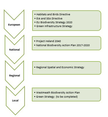
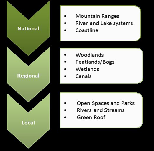
Figure 12.1 Policy Background to Green Infrastructure
12.19 Integration of Green Infrastructure in Westmeath
The Council identifies green infrastructure as a key strategic asset for the County and this Development Plan includes policy objectives for the protection, preservation, management and enhancement of this resource in an integrated manner.
The Council will continue to protect key environmental assets by implementing an environmental protection policy, which recognises the various environmentally sensitive areas and Natura 2000 sites within the County. This includes supporting and protecting the network of interconnected natural, semi-natural and managed areas which can include rivers and canals, our parks, agricultural lands and amenity sites which can deliver multiple benefits conserving natural eco-systems, managing flood risk and providing health and leisure benefits to those living, working and visiting the County.
The NPF and the RSES identify and support key Guiding Principles for Green Infrastructure Strategies to be incorporated by Local Authorities in the preparation of their strategies. This includes support for the provision of green and blue infrastructure, the development of Strategic Green Infrastructure and an associated network of walking and cycling routes, which will aid in mitigating climate change impacts through carbon sequestration and the delivery of alternative energy supply (further outlined in the Climate Action Chapter 11). The Council is committed to preparing a Green Infrastructure Strategy for the County during the period of this Development Plan.
12.20 A Green Infrastructure Strategy for Westmeath
It is the Council’s intention to develop a Green Infrastructure Strategy for the County in consultation will all key stakeholders during the lifetime of this Development Plan. This Strategy will identify key green infrastructure aims and objectives for Westmeath, taking account of the priority projects identified in this Development Plan and the delivery of these projects through appropriate funding mechanisms.
A Green Infrastructure Strategy will include provisions for improved access across Westmeath through improved walking and cycling routes whilst also ensuring adequate protection to the existing environment and ecology of the landscape.
The Council will continue to support and promote walking and cycling through the provision, upgrading and maintenance of cycleways and footpaths as resources allow and ensure that connectivity is provided in new developments with the provision of good pedestrian and cycle network and associated facilities.
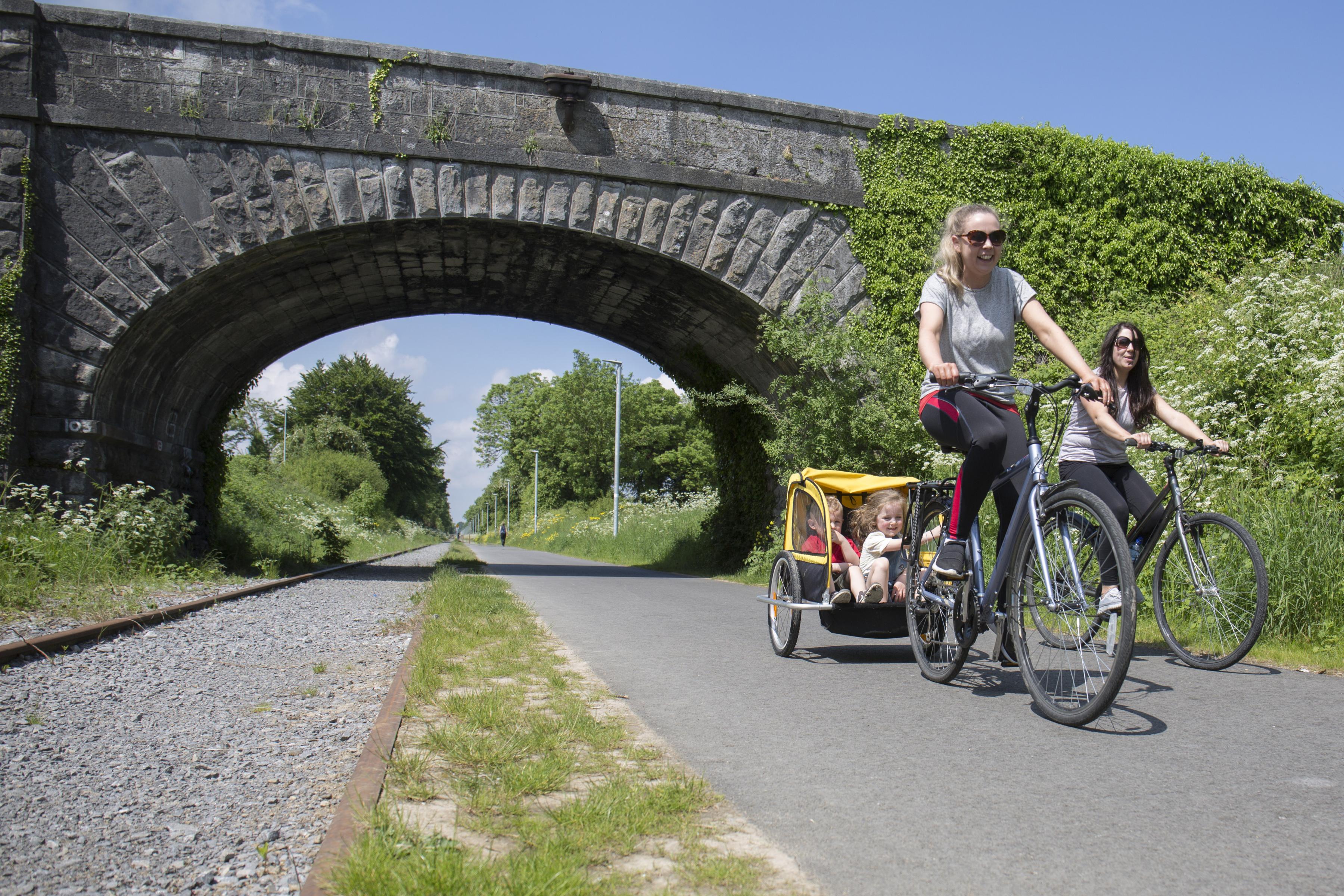
Figure 12.2: An example of Green Infrastructure in Westmeath
It is important to note that the existing green infrastructure is used and enjoyed not only by its residents, but also by its visitors, and is an important component of the County’s tourism offering, which is further examined in the Tourism Chapter 6 of this Plan.
It is notable that some of the features that make up Westmeath’s Green Infrastructure network transcend the County boundary into adjoining Local Authorities e.g. Lough Ree and peatlands in North
Westmeath and as such a collaborative approach should be taken to developing green infrastructure networks.
12.21 Green Infrastructure Management
A key objective of green infrastructure planning is that green infrastructure management and provision is integrated with land use planning. The development of green infrastructure networks is important both in rural and urban areas providing links to existing amenities and has a considerable bearing on quality of life issues.
Green Infrastructure Policy Objectives |
|
|
It is a policy of Westmeath County Council to: |
|
|
CPO 12.66 |
Identify, protect and enhance existing and planned Green Infrastructure assets and to facilitate, in consultation with relevant stakeholders, the development of Green Infrastructure that recognises the benefits that can be achieved with regards to the following:
|
|
CPO 12.67 |
Ensure green infrastructure responds to and reflects landscape character including historic landscape character, conserving and enhancing the existing landscapes and townscapes of Westmeath which contribute to a distinctive sense of place. |
|
CPO 12.68 |
Prepare and implement a ‘Green Infrastructure Strategy’ for the County, to raise awareness of the importance of environmentally designated sites, river and canal corridors, and green spaces to adapting to climate change and enhancing opportunities for recreation and tourism. |
|
CPO 12.69 |
Facilitate and promote the provision of a green infrastructure network serving the settlement hierarchy and its environs in tandem with projected population growth. |
|
CPO 12.70 |
Prepare specific Green Infrastructure Strategies for the designated settlements of Athlone and Mullingar and implement green infrastructure networks within these towns. |
|
CPO 12.71 |
Work collaboratively with other neighbouring Local Authorities in facilitating and supporting the development of green infrastructure networks. |
|
CPO 12.72 |
Support and increase investment in the provision and on-going maintenance of existing green infrastructure and support the provision of new public parks, greenway and blueway corridors and other public open spaces to create green, healthy settlements throughout Westmeath by accessing relevant EU funding mechanisms and national funding opportunities including tourism related funding. |
12.22 Greenways
Greenways are essentially shared off-road routes designed for cyclists and pedestrians for leisure, recreation, tourism and daily journeys and are reserved exclusively for non-motorised journeys, developed in an integrated manner which enhances both the environment and quality of life of the surrounding area. They provide recreational opportunities for walking, jogging and cycling and can often coincide with river/stream corridors and can promote free passage for wildlife.
The Council is fully committed to developing a network of greenways in accordance with the requirements of the Department of Transport, Sport and Tourism policy document entitled “Strategy for the Future Development of National and Regional Greenway”.
Considerable investment has been made in the development of greenways across the County in recent years. It is Council policy to maximise return on such investment, to promote the development of new greenways resulting in an integrated network of greenways within Westmeath. Map Volume 2 highlights the extent of greenways in the County. Please refer to Section 10.4.2 regarding the development of proposed greenways.
The Old Rail Trail which extends from Mullingar to Athlone for a distance of 42km and forms part of the Dublin to Galway National Cycle Network and the Royal Canal Greenway, which extends across the County form the backbone of the greenway network in Westmeath. The Council will continue to build upon this network, maximise pedestrian and cycle connectivity to same, provide greenways to existing lakes within the County and seek to connect existing greenways to create an integrated tourism product and thus make Westmeath a premier cycling destination.
Future Greenway corridors and projects in Westmeath will be identified through a Green Infrastructure Strategy and will need to comply fully with the requirements and objectives of the Habitats Directive to ensure the continued protection and preservation of the Countys significant biodiversity.
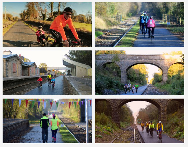
Figure 12.3: Greenways in County Westmeath
Greenways Policy Objectives |
|
|
It is a policy of Westmeath County Council to: |
|
|
CPO 12.73 |
Support the development of an integrated Strategic Greenway Network of national and regional routes and maximise connectivity to existing greenways and link with cycling and walking infrastructure. |
|
CPO 12.74 |
Support the delivery of sustainable strategic greenways, blueways and peatways projects in the County in accordance with the Strategy for the Future Development of National and Regional Greenways. |
|
CPO 12.75 |
Develop the Mullingar Greenway incorporating a pedestrian/cycle link connecting Mullingar to Lough Ennell and Belvedere subject to environmental and habitats requirements. |
|
CPO 12.76 |
Enhance and link the Westmeath Way through Mullingar via the Royal Canal Feeder and further along the waterside via Tullaghan and to the north eastern side of Lough Owel, consistent with Habitat Management Plan objectives for the lake. |
12.23 Blueways
Blueways consist of a network of navigable inland waterways such as lakes, canals and rivers and include the Shannon and Shannon-Erne Waterway connecting the islands of Lough Ree, Clonmacnoise and Shannon Harbour and linking the Royal Canal with the Grand Canal along the River Shannon. They provide scenic routes by canoe, bike or on foot.
In Westmeath the Blueway consists of the Royal Canal Paddling Trails, extending from Mullingar via McNead’s Bridge and Coolnahay which is part of the Royal Canal Greenway, an off-road cycling trail along the canal banks from the River Shannon in Clondra, County Longford all the way towards Dublin.
The Council recognises that Blue and Green Infrastructure has many valuable economic, social and environmental benefits for the County and should be preserved where possible as natural defences against flood risk in both urban and rural areas. Given the number of lakes and canals in the county, it is Council policy to develop a network of integrated blueways in the county.
Blueways Policy Objectives |
|
|
It is a policy of Westmeath County Council to: |
|
|
CPO 12.77 |
Develop an integrated network of blueways both within Westmeath and to adjoining counties. |
|
CPO 12.78 |
Support the development of blueways and associated infrastructure as part of the tourist offering of the County. |
12.24 Public Rights of Way
The Planning and Development Acts 2000 (as amended) requires a County Development Plan to indicate locations on a map and to preserve public rights of way, which give access to seashore, mountain, lakeshore, riverbank or other place of natural beauty or recreational utility.
Existing public rights of way constitute an important amenity and they enable the enjoyment of high-quality landscapes, providing a valuable link to natural assets and places of natural beauty such as the lakes, bogs and forests to those that live and visit the County. There are a number of public accesses to the lakes within the county.
There are several walking routes throughout the County through publicly owned lands including the Royal Canal Way and Coillte forests such as Mullaghmeen and Slí Na Sláinte. There are other pedestrian rights of way within the County such as mass paths, which have existed for centuries but not all of which are readily identifiable.
The Council recognises the importance of maintaining established rights of way and supports initiatives for establishing new walking routes and enhanced accessibility.
Appendix 6 lists Public Rights of Way that have been identified within the county, which will be the subject of further investigation. This list is not exhaustive, and it is intended this will be added to during the lifetime of the Plan.
Public Rights of Way Policy Objectives |
|
|
It is a policy of Westmeath County Council to: |
|
|
CPO 12.79 |
Cooperate with Coillte in the establishment of access ways, nature trails etc. with a view to opening up state forests for recreational use, compatible with forestry requirements. |
|
CPO 12.80 |
Review and protect existing public rights of way for the common good and bring forward proposals for the creation of public rights of way. Where appropriate, links to established public rights of way in adjoining counties will be identified. |
|
CPO 12.81 |
Ensure that Public Rights of Way are well marked and signposted. |
Contents
Observations
Observations
Submission from Cllr. Louise Heavin re: Natural Heritage Landscape & Amenities & Cultural Heritage
Submission from Jonathan Deane Environment Department Westmeath County Council re:Tree Planting Policy
As part of the consultation on the Draft County Development Plan, we in the Environment Directorate would request that the inclusion of a ‘Tree Planting policy’ is seriously considered for the...
Submission from Vanessa Liston re: Tree and Hedgerow protection policies
I suggest that Policy CPO 12.37 be strengthened by referring to tree protection standards follows BSI e.g BS 5837:2012 and BS: 3998:2010 among others.
Suggested...
Submission by Labour: Cllr Denis Leonard and Cllr Johnny Penrose: Need for the correct location of wind energy infrastructure in correct locations
Re: Draft County Development Plan 2020.
Dear Sir/Madam,
I have reviewed the recent Draft of the County Development Plan (hereinafter called "the draft") and wish to make the following...
Submission from George Smith re: Wetlands and biodiversity
See attached submission