please see attachment that provides comprehensive submission.
02. Core Strategy
Dúnta28 Fea, 2020, 1:00pm - 30 Mei, 2020, 5:00pm
2.1 Rationale for Core Strategy
Part V of the Planning and Development Act 2000 (as amended) contains requirements for all Planning Authorities to ensure that their Development Plans are consistent with high-level strategic policies and population projections for the country. Planning Authorities are required to prepare and incorporate a Core Strategy that shows the Development Plan is consistent with national and regional objectives under the National Planning Framework (NPF) and the relevant Regional Spatial and Economic Strategy (RSES). The NPF was adopted and published by the Government on 16th February 2018, as a strategy to replace the National Spatial Strategy 2002-2020. The RSES replaced the Regional Planning Guidelines (RPGs) for the Midland Region and were introduced under the Local Government Reform Act 2014 which envisaged RSESs co-ordinating not only the physical planning process, as was the case with RPGs and Development Plans, but also the Local Economic and Community Plans (LECPs) that have been prepared by local authorities under the 2014 Act. The NPF and relevant RSES are thus of direct statutory relevance to the preparation of County Development Plans.
Under the Act, a Core Strategy focuses on:
- Defining a settlement hierarchy for the County that is consistent with the NPF and RSES.
- Transposing the prescribed NPF and RSES housing and population targets set at County level for the rural and urban centres identified within the settlement hierarchy.
- Providing an evidence-based rationale for the land proposed to be zoned for residential and mixed-use development having regard to the capacity of existing zoned land and the phasing of development taking account of the location of public transport and services.
- Demonstrating how the Planning Authority has had regard to the statutory Retail Planning Guidelines in setting out objectives for retail development.
The Core Strategy sets out a vision for Westmeath and strategic aims required to deliver this vision. The development of this Core Strategy has been guided by the Department of Environment Heritage and Local Government ‘Guidance Note on Core Strategies’ (2010), taking into account relevant changes brought about through the publication of the NPF and RSES. Encompassed within this are revised population targets, zoning requirements and associated policies to ensure consistency with these updated national and regional strategies. These are expressed in the Core Strategy Table (table 8) and related zoning maps.
2.2 Strategic Development of County Westmeath over the Plan Period 2021-2027 within a national context (NPF)
The National Planning Framework (NPF) is a high-level strategy that will shape growth and development in Ireland out to the year 2040. The NPF draws upon lessons learned from the National Spatial Strategy 2002-2022 and provides a framework for the sustainable development of Ireland’s existing settlements. As a framework document it sets in train a process by which more detailed planning documents must follow, including the relevant RSES and County Development Plan. It sets out ten National Strategic Outcomes (NSO’s) which underpin the overarching vision for the country and serve as shared goals, as depicted in figure 2.1. The Strategy also contains a range of National Policy Objectives providing a wider context for targeting future growth across the country.

Figure 2.1: NPF National Strategic Outcomes. Source: NPF, p13
With regards the Eastern and Midland Region, the NPF states that the region’s most significant place-making challenge will be to plan and deliver future development in a way that enhances and reinforces its urban and rural structure and moves more towards self-sustaining, rather than commuter driven activity. In turn, this allows its various city, metropolitan, town, village and rural components to play to their strengths, while above all, moving away from a sprawl-led development model. The NPF identifies an urban structure for the Region based on commuting patterns, with reference to the EU/OECD definition of ‘functional urban areas’ (FUAs) which is used to identify areas with different sub-regional interdependencies and influence in the region. The FUAs support and augment the Strategic Planning Areas (SPAs), which provide for a sub-regional planning remit, through recognising spatial, social and economic similarities and differences within each SPA. These FUAs are:
- The Dublin Metropolitan Area (DMA)
- The Core Region; which is the peri-urban ‘hinterlands’ within the commuter catchment around Dublin, which covers the Eastern counties and extends into the Midlands, north into Louth and south beyond the Region into Wexford.
- The Gateway Region; includes the Midlands and north east border areas, outside the Core Region, which are strategically located as inter-regional portals to the Northern and Western and Southern Regions, where over 400,000 people reside. The Gateway Region also includes the Regional Centres of Athlone and Dundalk.
In terms of the settlement hierarchical structure, the NPF abolished the linked Gateway status which was attributed to the gateway towns of Athlone, Tullamore and Mullingar under the NSS. Athlone has now been designated as a ‘Regional Centre’ and has been identified as a focal point within the region and neighbouring regions in economic and employment, transport, education and public service delivery and retailing terms. Given the importance of regional interdependencies, the NPF directs that it will be necessary to prepare a co-ordinated strategy for Athlone at both regional and town level, to ensure that the town and environs has the capacity to grow sustainably and to secure investment as the key regional centre in the Midlands. In the same way that the NPF requires Metropolitan Area Strategic Plans to be prepared for each of the five cities, a strategic plan that responds to the lead role of each of the five identified regional centres is also required. These consolidated plans will address a high-level strategy approach to the future of each centre. Where these regional centres straddle local authority boundaries, the preparation of these plans must be jointly and collaboratively undertaken. This is the case for Athlone – with collaborative efforts required by Westmeath County Council and Roscommon County Council.
The NPF further states that there is scope for potential growth in all towns in Ireland and this will largely be determined by the relevant Regional Spatial and Economic Strategy (RSES) for each Regional Assembly area, also taking into consideration the potential of smaller settlements and rural areas. Moreover, the NPF asserts that “in setting overall targets for future growth, it is a pattern of development that is being targeted, rather than precise numbers. From a long-term, national perspective, the targeted location, relative scale and proportionality of growth will assist in monitoring and assessing delivery and performance”.
In terms of specific national objectives relevant to Westmeath, the NPF includes a number of targets aimed at growing the Eastern and Midland Region (NPF; p26):
- Policy Objective 1a: The projected level of population and employment growth in the Eastern and Midland Regional Assembly area will be at least matched by that of the Northern and Western and Southern Regional Assembly areas combined.
- Policy Objective 1b: Eastern and Midland Region: 490,000 - 540,000 additional people i.e. a population of around 2.85 million;
- Policy Objective 1c: Eastern and Midland Region: around 320,000 additional people in employment i.e. 1.34 million in total;
Furthermore, the NPF includes specific targets related to securing compact and sustainable growth in Ireland’s towns and cities, recognising that the physical format of urban development in Ireland is one of our greatest national development challenges. As such it states that within the Eastern and Midlands Region, 30% of all housing outside of Dublin City and its suburb footprints are to be delivered within existing urban footprints.
The NPF further states that projecting housing requirements more accurately into the future at a Regional Spatial and Economic Strategy and local authority development plan level (e.g. through Core Strategies) will be enabled by the provision of new statutory guidelines to ensure consistency of approach, implementation and monitoring. This is enshrined in National Policy Objective 36 (NPF; p95);
- National Policy Objective 36: New statutory guidelines, supported by wider methodologies and data sources, will be put in place under Section 28 of the Planning and Development Act to improve the evidence base, effectiveness and consistency of the planning process for housing provision at regional, metropolitan and local authority levels. This will be supported by the provision of standardised requirements by regulation for the recording of planning and housing data by the local authorities in order to provide a consistent and robust evidence base for housing policy formulation.
2.2.1 Implementation Roadmap for the National Planning Framework
The Implementation Roadmap for the National Planning Framework (July 2018) highlights the Governments focus on achieving alignment between national, regional and local planning policy and practice. It addresses issues around the legal status of the NPF and provides transitional population projections for the period up to 2031. It also sets out mechanisms to ensure that Development Plans will broadly align with the NPF and RSES’s to address the six-year period up to 2026/2027.
Given the above, 2026-2027 will allow the assessment of the first full round of Development Plans prepared in accordance with the NPF and the RSES. This assessment will coincide with several other key dates; 2026 is a Census Year, and 2027 will see the review of the ten-year National Development Plan. It is further noted that Development Plans approved in 2020/21 will commence reviews in 2025/2026 and so require demographic data for the six-year period beyond to 2031.
Therefore, it is stated that “The critical population projection periods are to 2026 and 2031, with a particular emphasis on the initial six-year period to 2026, for city and county development plans that are to be formulated during the 2019-20/21 period” (NPF Implementation Roadmap, p4). The Roadmap provides transitional population projections for these milestones at a regional and county scale, in order to inform Development Plans for the period 2026 and 2031. The transitional population projections for the Eastern and Midland Region are listed in Table 2.1 below. For the purposes of this Development Plan (2021-2027), figures up to 2027 are also considered in subsequent sections.
Table 2.1: Transitional Regional and County Population Projections to 2031 for the Eastern and Midland Regional Assembly.
Source: NPF Implementation Roadmap, p13
|
Regions and Counties |
2016 |
2026 |
2031 |
|---|---|---|---|
|
Mid-East |
|||
|
Kildare |
222,500 |
249,000-254,000 |
259,000-266,500 |
|
Meath |
195,000 |
216,000-221,000 |
225,500-231,500 |
|
Wicklow |
142,500 |
155,000-157,500 |
160,500-164,000 |
|
Louth |
129,000 |
139,000-144,500 |
144,000-151,500 |
|
Subtotal |
689,000 |
759,000-777,000 |
789,000-813,500 |
|
Midlands |
|||
|
Westmeath |
89,000 |
96,500-98,500 |
100,000-102,500 |
|
Laois |
84,500 |
92,500-94,000 |
95,500-97,500 |
|
Offaly |
78,000 |
85,000-86,500 |
88,000-90,000 |
|
Longford |
41,000 |
44,500-45,500 |
46,000-47,000 |
|
Subtotal |
292,500 |
318,500-324,500 |
329,500-337,000 |
|
Dublin |
|||
|
Dublin |
1,347,500 |
1,489,000-1,517,500 |
1,549,500-1,590,000 |
|
Total |
2,329,000 |
2,566,500-2,619,000 |
2,668,000-2,740,500 |
2.3 Strategic Development of County Westmeath within a Regional Context (Eastern & Midlands Region)
The Regional Spatial and Economic Strategy (RSES) for the Eastern and Midland region came into force in June 2019, superseding the Regional Planning Guidelines for the Midland Region. The RSES is a high- level plan that seeks to support the implementation of the NPF by providing a strategic planning and economic framework for the region’s sustainable growth and development. It echoes the NPF in emphasising sustainable development patterns and seeks to focus growth within the footprint of existing urban areas and in key regional growth settlements.
The RSES seeks to determine at a regional scale how best to achieve the shared goals set out in the National Strategic Outcomes (NSOs) of the NPF. To this end, the Strategy sets out 16 Regional Strategic Outcomes (RSOs), which are aligned with international, EU and national policy and which in turn set the framework for City and County development plans. These are illustrated in Figure 2.2.
In relation to Westmeath, the Settlement Strategy for the region designates Athlone as a Regional Growth Centre and aims to promote Athlone’s sustainable and compact growth by setting the town a target population of 30,000 up to 2031. The RSES acknowledges that Athlone includes lands within the combined functional area of two Local Authorities; Westmeath and Roscommon County Councils. As such, a key priority is the preparation and adoption of a Join Urban Area Plan by Westmeath and Roscommon County Councils.
The strategy further designates Mullingar as a Key Town, recognising that the town provides a function at a much higher level than its resident population and provides key employment and services for its extensive hinterlands. This designation for Athlone and Mullingar sits within a wider settlement hierarchy which consists of seven settlement tiers (see table 2.2) as follows; Dublin City and Suburbs; Regional Growth Centres; Key Towns; Self Sustaining Growth Towns; Self Sustaining Towns; Towns and Villages; Rural. Within the top three tiers of the hierarchy, settlements are clearly defined with the RSES. Settlements within the other four tiers are to be further defined in the County Development Plans.
Within the higher order settlements of Athlone and Mullingar, the RSES asserts that core strategies should apply higher densities in these towns. However, the RSES further states there should be a graded reduction in residential densities for Self-Sustaining Growth Towns, Self-Sustaining Towns, towns and villages that are commensurate to the existing built environment.

Figure 2.2: EMRA Regional Strategic Outcomes (RSOs). Source: EMRA RSES, p24
Table 2.2: RSES Settlement Hierarchy for the Eastern and Midland Regional Assembly Region.
Source: EMRA RSES, p44
|
Settlement Typology |
Description |
Areas |
||
|---|---|---|---|---|
|
|
Metropolitan |
Core Region |
Gateway Region |
|
|
Dublin City and Suburbs |
International business core with a highly concentrated and diversified employment base and higher order retail, arts, culture and leisure offer. Acts as national transport hub with strong inter and intra- regional connections and an extensive commuter catchment. |
Dublin City and suburbs |
||
|
Regional Growth Centres |
Regional Growth Centres are large towns with a high level of self- sustaining employment and services that act as regional economic drivers and play a significant role for a wide catchment area. |
|
Drogheda |
Athlone Dundalk |
|
Key Towns |
Large economically active service and/or county towns that provide employment for their surrounding areas and with high-quality transport links and the capacity to act as growth drivers to complement the Regional Growth Centres. |
Bray Maynooth Swords |
Navan Naas Wicklow-Rathnew |
Graiguecullen (Carlow) Longford Mullingar Tullamore Portlaoise |
|
Self- sustaining growth towns |
Self-Sustaining Growth Towns with a moderate level of jobs and services – includes sub-county market towns and commuter towns with good transport links and capacity for continued commensurate growth to become more self-sustaining |
To be defined by Development Plans |
||
|
Self- Sustaining Towns |
Self-Sustaining Towns with high levels of population growth and a weak employment base which are reliant on other areas for employment and/or services and which require targeted ‘catch up’ investment to become more self-sustaining. |
To be defined by Development Plans |
||
|
Towns and villages |
Towns and villages with local service and employment functions |
To be defined by Development Plans |
||
|
Rural |
Villages and the wider rural region |
To be defined by Development Plans |
||
In developing this settlement hierarchy, the RSES recognises that population and employment size are not the sole determinant of a settlement’s functional role or in the consideration of its strategic regional significance. The strategy states that;
‘Some towns with a large population base located within the catchment of Dublin have emerged mainly as commuting towns, with a level of function significantly lower than their population base. Conversely, other towns have a level of function higher than their population base and play a key regional role’ (EMRA RSES, P46).
The RSES settlement hierarchy was informed by an evidence driven Settlement Typology and Asset- Based approach, which identifies key assets and capacity issues in the Region’s settlements and seeks to ensure that all places can meet their full potential and support the health and wellbeing of people who live, work, study in or visit the Region as well as the environment with which they interact. A number of key criteria were considered in the development of the asset base, which can be summarised as follows:
- Scale: The scale of population, growth rates and local ambition for sustainable compact growth
- Function: The scale of employment provision and commuting flows; Particular sub-regional interdependencies and influence
- Human Capital: The extent of local services provision i.e. administration, education- particularly third level, health, retail and amenities; Levels of relative affluence or deprivation
- Enterprise: The availability of economic development assets and clusters
- Placemaking: This is linked to ‘Functionality’ in terms of provision of suitable sites and property solutions to meet enterprise and labour force expectations
- Connectivity: Transport accessibility and trip profiles, including internal trips
- Environmental/Natural Capital: Environmental sensitivities, resources and assets
- Infrastructure: Current and planned infrastructure capacity
This approach has been utilised to guide the development of Westmeath’s Settlement Hierarchy, as elaborated in section 2.6.
2.4 Housing Need Demand Assessment (HNDA)
Under Section 94 (1) (a) of the Planning and Development Act 2000 (as amended), each planning authority “shall include in any development plan a strategy for the purpose of ensuring that proper planning and sustainable development of the area of the development plan provides for the housing of the existing and future population of the area in the manner set out in the strategy”.
In order to ensure that the plan-making system is supported by a robust methodology to inform policies and funding initiatives around housing and associated land requirements, the NPF states that a Housing Need Demand Assessment (HNDA) will be developed by each Local Authority to support the preparation of housing strategies and all related housing policy outputs, e.g. City and County development plans, local area plans, traveller accommodation plans etc.
The purpose of the HNDA tool is to:
- Assist local authorities to develop long-term strategic views of housing need across all tenures.
- Provide a robust evidence base to support decisions about new housing supply, wider investment and housing related services that inform an overall national housing profile.
- Inform policies about the proportion of social and affordable housing required, including the need for different types and sizes of provision.
- Provide evidence to inform policies related to the provision of specialist housing and housing related services.
In 2010, the Department of Environment Heritage and Local Government published a Guidance Note on Core Strategies requiring the Housing Strategy to be informed by the Core Strategy as regards overall population and housing land requirements. The Guidelines (2010) further state that the purpose of the Core Strategy is to articulate a medium to longer term quantitatively based strategy for the spatial development of the area of the planning authority and in so doing to demonstrate that the development plan and its objectives are consistent with national and regional development objectives. The Core Strategy must therefore give effect to the NPF and RSES hierarchy (as extended at County level) by setting population targets and associated requirements for housing. This must now be undertaken through the HDNA process.
This Core Strategy Chapter sets out the population targets and broad housing requirements for Westmeath for the period 2021-2027 (see section 2.8). The HNDA process is elaborated and presented in greater detail in the Housing Strategy (see Appendix 1).
2.5 Strategic Aims
The strategic aims which relate to the advancement of this plan are set out hereunder. These aims are addressed more fully in subsequent chapters within the plan. A series of specific Core Strategy policy objectives are included in Section 2.22.
- To guide the future development of Westmeath in line with national and regional objectives set out in the NPF and RSES and other national guidelines and policies
- To promote and facilitate the development of the County in accordance with the provisions of the Core Strategy, including directing development in line with the settlement hierarchy and promoting development at an appropriate scale that is reflective of the terms of the Core Strategy Table and zoning maps.
- To apply the Settlement Hierarchy to determine the scale, rate and location of proposed developments and apply appropriate development management measures to ensure compliance with the Settlement Hierarchy including the population targets for the County.
- To promote the delivery of at least 30% of all new homes that are targeted in settlements within their existing built-up footprints
- To support the achievement of more self-sustaining towns and villages through residential and employment opportunities together with supporting social and community facilities
- To monitor and maintain a record of residential development permitted in settlements designated under the Settlement Hierarchy in order to ensure compliance with the population allocations defined by the Core Strategy and to adjust the approach to permitting development proposals in instances where Core Strategy objectives are not being met.
2.6 Population Trends and Targets
Census 2016 results show that Ireland’s population stood at 4,761,865 in April 2016, an increase of 173,613 (3.8%) since April 2011. There were 200 urban settlements across the country, which together accommodated 63% of Ireland’s population1. Beyond the five cities (Dublin, Cork, Limerick, Galway and Waterford) 29% of Ireland’s population live in towns and villages with at least 1,500 or more people. The Census data further indicates that smaller towns and villages (1,500-10,000 population) experienced less than half the national average rate of population growth between 2011 and 2016. Those with more than 5,000 people had a combined net loss of population during that time, when the national population grew by almost 4%. Within Westmeath, the County saw a population increase of 3% (+2,606 persons) during this period, as the population increased to 88,770 from 86,164. However, there are significant variances in population trends across the County.
Athlone and Mullingar continued to experience steady growth between 2011 and 2016, with their populations increasing by 4.5% and 4.1% respectively. Both settlements now exceed populations of 20,000. Although it should be noted that in the case of Athlone, this figure includes the population of Monksland. The combined population of Athlone and Mullingar represents a total of 47.6% of the County’s population. In 2011 this figure stood at 41.6%. Of the other larger towns in the County, a further two can be characterised as ‘urban’ – Moate and Kinnegad. During this period, these towns grew by 1.17% and 3.1% respectively.
Four more towns in the County recorded populations of more than 1,000 inhabitants (Rochfortbridge, Killucan-Rathwire, Kilbeggan, and Castlepollard). Of these, only Rochfortbridge experienced minor decline (-1.4%) between 2011-2016. The remaining three settlements experienced growth rates of between 3.4% and 11.7%. The figure of 11.7% relates to Killucan/Rathwire, which grew by 144 persons during this period, reaching a total of 1,370 inhabitants. Castlepollard also experienced significant growth during this period, increasing by 11.6% to 1,163 inhabitants.
2.6.1 Population Distribution
According to the CSO’s parameters, a total of 47,785 people (53.8%) were living in urban settlements in Westmeath in 2016. 40,985 (46.1%) were living in smaller towns and villages, as well as in the rural remainder of the County. In 2011, census results showed a distribution between the urban and rural population as 48.54% and 51.46% respectively. Thus, Westmeath is becoming more urban in nature as a whole. The population growth in Westmeath for rural and urban areas from 2006 to 2011 was 6.2% and 11.2% respectively. Between 2011 and 2016, rural areas grew by 8.1%, while urban areas (i.e. Athlone, Mullingar, Kinnegad and Moate) grew by 14.2%.
2.6.2 Population Structure
The Census 2016 results show that Ireland’s population has been getting steadily older since the 1980s. In 2016, 37.2% of the Irish population were aged 45 and over, compared with 34.4% in 2011 and 27.6% in 1986. 13.4% of the state’s population were over 65 in 2016. Within the EMRA region, this figure stood at 12% (as shown in figure 2.4 below). The comparative figures for Westmeath are shown in figure 2.3.
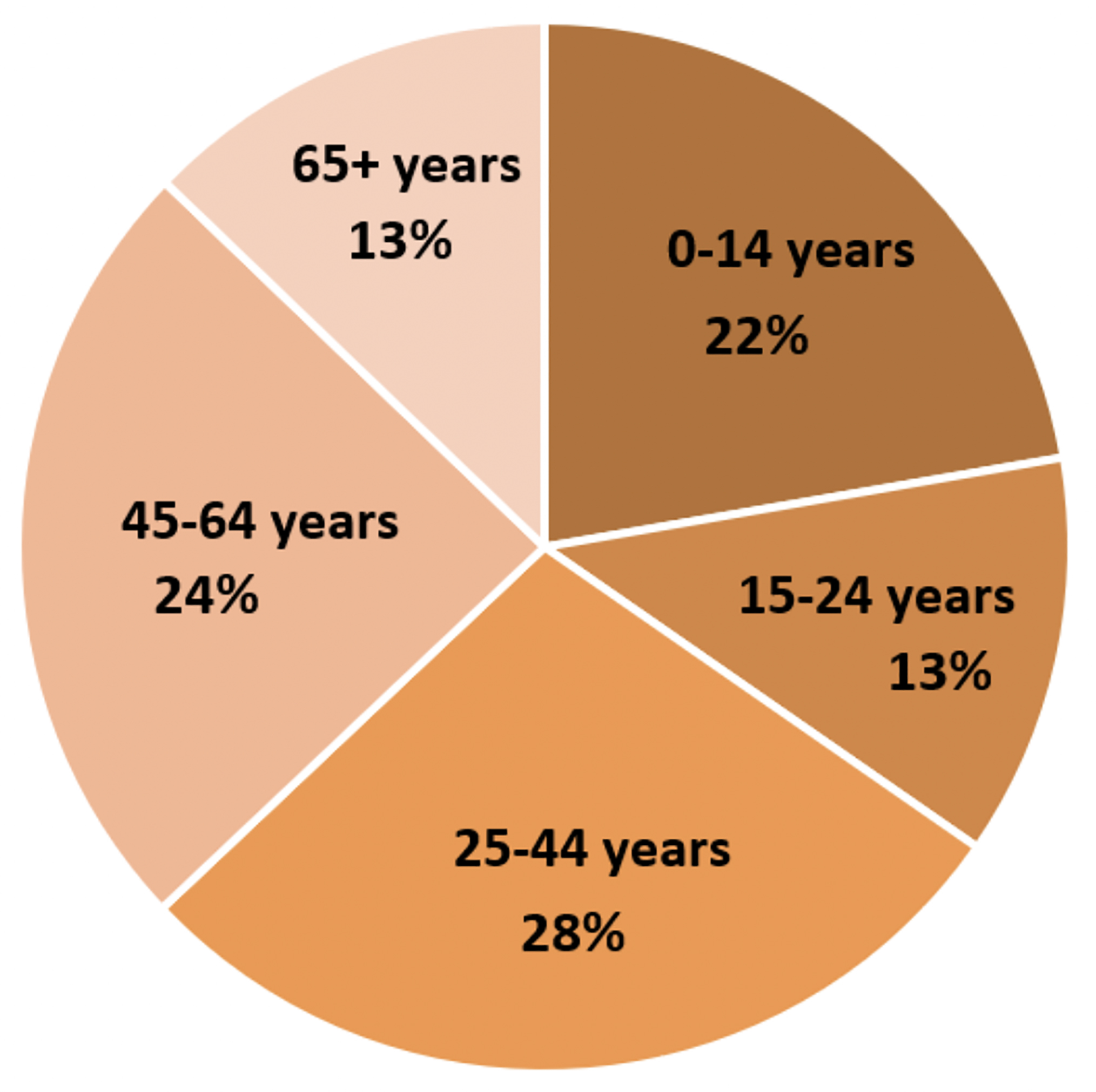
Figure 2.3: Westmeath Age Profile (CSO, 2016)
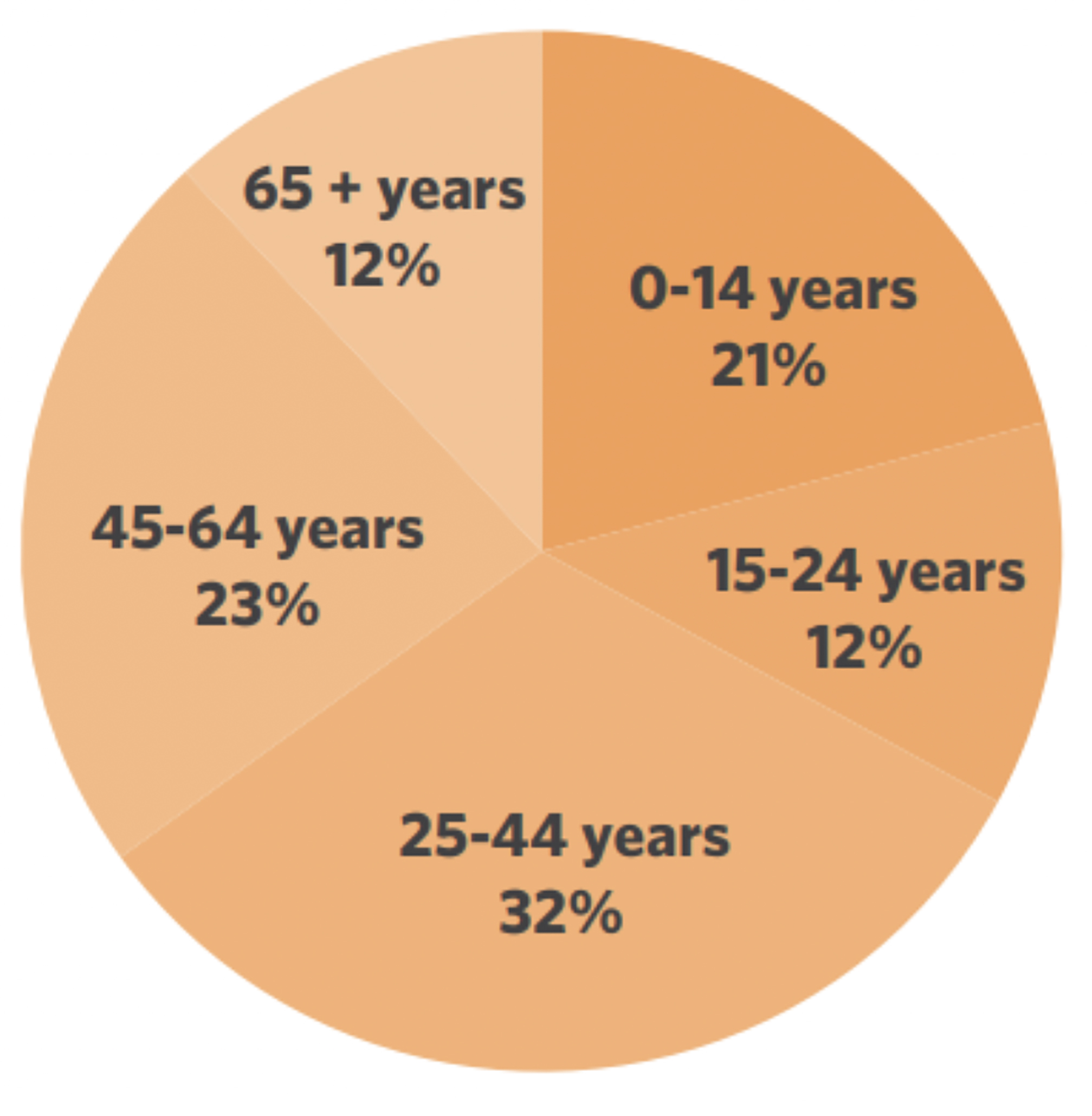
Figure 2.4: EMRA Age Profile (CSO, 2016)
In Westmeath, the proportion of the County aged over 65 is slightly lower than the national rate, with 13% of the population within this cohort. The average age of the County’s inhabitants is 36.3 years old in contrast to the national average age of 37.4. 22.3% of the Westmeath’s population is aged under 14. In total, the number of children of pre-school age (0-4) in Westmeath is 6464 (7.3%). 10,765 (12.1%) are of primary school going age (5-12) and a further 7493 (8.4%) are of secondary school going age (13- 18). An extended age of the County is presented in figure 2.5 below.
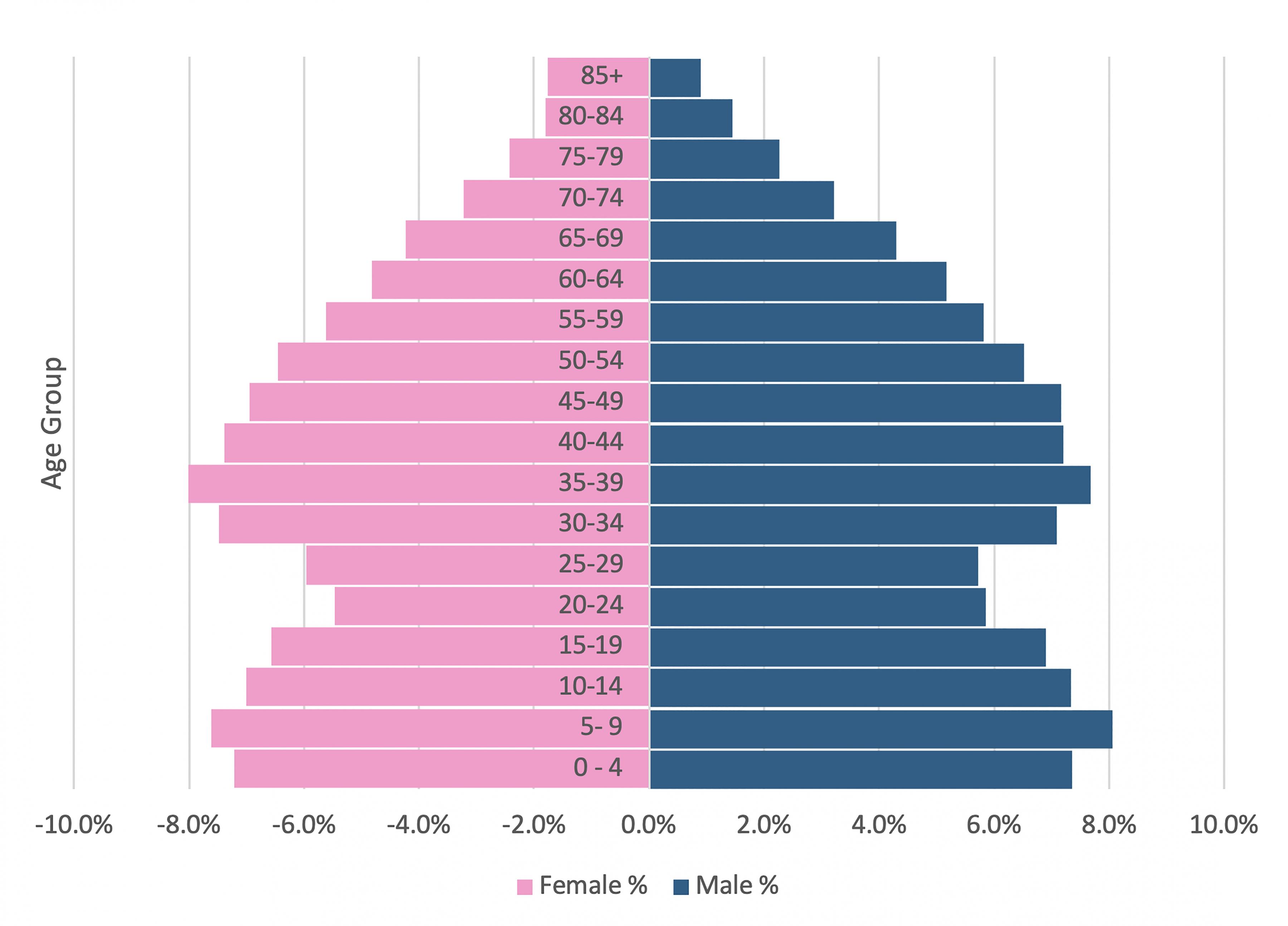
Figure 2.5: Westmeath Extended Age Profile (CSO, 2016)
2.7 Settlement Hierarchy
In developing a settlement hierarchy for County Westmeath, an Asset Based Approach similar to that used in the preparation of the RSES was adopted. This amended version identifies and builds on a combination of social, economic and natural assets and potential that is available within towns and smaller settlements in the County. This has also been informed by the criteria listed in the Hierarchy of Settlements and related Infrastructure considered by NPF (see figure 6 below). These criteria are grouped under eight overarching themes, with criteria graded according to the size of the settlement in question (i.e. Smaller settlements and rural areas; Smaller towns and villages; Large towns; and Cities).

Figure 2.6: Hierarchy of Settlements and related Infrastructure considered by NPF (Source: NPF; page 83)
In assessing settlements in Westmeath, several core factors have been considered to date, as presented in table 2.3.
Table 2.3: Summary of criteria utilised to develop the draft settlement hierarchy for Westmeath 2021-2027
|
Criteria |
Description |
Rationale |
|---|---|---|
|
SCALE |
||
|
Population |
Population resident within CSO defined settlement boundary |
Settlements with critical mass of population to drive regional development |
|
Growth Rate |
% Growth rate between 2011- 2016 (Westmeath growth rate was 3.02%) |
Growth rate will determine capacity for future growth. Towns that have experienced high growth rates may require additional investment in services, infrastructure and employment |
|
NPF/RSES designation |
Settlements designated for growth in the NPF include Dublin Metro and Regional Growth Centres |
The NPF identified a number of centres of scale, which have the potential to meet the critical mass to drive regional growth – these include the Regional Growth Centre of Athlone and the Key Town of Mullingar. |
|
FUNCTION |
||
|
Commuter Trips |
Journey times from the settlement to work, school or college |
The scale of commuting flows will inform the characterisation of a settlement as commuter focused or as more self-sustainable. |
|
Ratio between workers and jobs (where relevant data is available) |
By undertaking an analysis of the POWCAR 2016 database it is possible to develop a profile of both the number of resident workers and then importantly the actual number of local jobs. The average ratio of jobs to resident workers in the Eastern and Midland Regional Assembly area is 0.86. |
An analysis of the ratio between workers and jobs at the settlement level reveals the economic importance of a number of Westmeath towns for surrounding areas. |
|
Retail Hierarchy |
Retail hierarchy based on the Retail Strategy reflected in the Plan. |
Consideration must be given to the retail hierarchy included in Westmeath Retail Strategy |
|
SOCIAL INFRASTRUCTURE / PLACE MAKING |
||
|
Community Facilities |
Sustainable neighbourhoods require a range of community facilities as stated in the Department of Environment, Heritage and Local Government Guidelines on Sustainable Residential Development in Urban Areas (2009). |
The extent of local services provision (such as shops, schools, pre-school facilities, community halls or centres; medical centres etc) will determine the attractiveness of a settlement to attract and retain a critical mass of population. |
|
ENTERPRISE |
||
|
Economic Assets |
Higher Education Centres, Business Incubation and Innovation Centres, Technology Gateways and Research Centres, IDA Business parks or industrial estates, local enterprise office, and Strategic sites |
Firms and enterprise development are drawn to urban locations by market forces such as agglomeration, migration and specialisation that depend on factors such as scale, accessibility, innovation supported by higher education institutions and quality of life. Moreover, as the NPF (p75) notes, Ireland’s natural resources are some of our greatest assets and through the development of the agriculture, food, forestry, tourism and renewable energy sectors, this will not only sustain rural employment, but also contribute to driving the national economy. |
|
CONNECTIVITY |
||
|
Public Transport |
Proximity to high quality public transport, both existing and planned. |
Access to transport infrastructure influences the location of housing and employment growth, with compact settlements more efficient in terms of maximising returns on transport investment |
|
Mode Share |
% Mode share of work and education trips (Origin) by Active Travel (walk, cycle), Public Transport, Car (driver, passenger). EMRA averages; active travel (21%), PT (14%), Car (56%). |
Mode share data indicates the extent of car dependency in a settlement |
|
NATURAL CAPITAL |
||
|
Flood Risk (RPS -RFRA) |
Flood Risk Summary of key Towns from SEA Environmental Report. Includes Flood Zones, constraints and measures identified in the FRMP along with assessment of climate change and adaption measures |
Future development and flood risk assessment will need to consider and address flood risk at settlement level. |
Source: Amended RSES Asset Based Approach; EMRA RESE, Appendix A.
2.7.1 Settlement Hierarchy for Westmeath 2021-2027
Table 2.4: Settlement Hierarchy for Westmeath
|
Settlement Typology |
Description |
Settlements |
Population 2016 |
|---|---|---|---|
|
Regional Growth Centre |
Regional Growth Centres are large towns with a high level of self-sustaining employment and services that act as regional economic drivers and play a significant role for a wide catchment area. |
Athlone* |
21,349 |
|
Key Towns |
Large economically active service and/or county towns that provide employment for their surrounding areas and with high-quality transport links and the capacity to act as growth drivers to complement the Regional Growth Centres. |
Mullingar |
20,928 |
|
Self-sustaining growth towns |
Self-Sustaining Growth Towns with a moderate level of jobs and services – includes sub-county market towns and commuter towns with good transport links and capacity for continued commensurate growth to become more self- sustaining |
Castlepollard |
1163 |
|
Moate |
2763 |
||
|
Kinnegad |
2745 |
||
|
Kilbeggan |
1288 |
||
|
Self-Sustaining Towns |
Self-Sustaining Towns with high levels of population growth and a weak employment base which are reliant on other areas for employment and/or services and which require targeted ‘catch up’ investment to become more self-sustaining. |
Rochfortbridge |
1473 |
|
Killucan /Rathwire |
1370 |
||
|
Towns and villages |
Towns and villages with local service and employment functions |
Clonmellon |
664 |
|
Tyrrellspass |
483 |
||
|
Delvin |
740 |
||
|
Rural (Serviced) |
Villages that serve their local area |
Multyfarnham |
420 |
|
Ballymore |
483 |
||
|
Ballynacarrigy |
277 |
||
|
Milltownpass** |
299 |
||
|
Collinstown |
356 |
||
|
Glasson |
207 |
||
|
Ballinalack** |
137 |
||
|
Castletown- Geoghegan |
141 |
||
|
Rural Remainder |
36,221 |
||
* The figure for Athlone represents the total population of the town encompassing both Westmeath and Roscommon
** Approximation of settlement due to CSO disclosure constraints
2.8 Population Estimates and Projections to meet Regional population targets
The NPF Implementation Roadmap states that “As the six-year City and County Development Plans approved in 2020/21 will commence review in 2025/26, this will require demographic data for the period beyond 2026 and the next iteration of RSESs will address the period to at least 2031”. As such, the critical population projection periods are to 2026/27 and 2031, with a particular emphasis on the initial six-year period to 2027 for this Development Plan. The Roadmap provides transitional population projections for these milestones at a regional and County scale, in order to inform Development Plans for the period 2026 and 2031.
These transitional population projections plot a growth trajectory set approximately mid-way between what is currently being planned for in statutory Development Plans if projected forward to 2031, and the more likely evidence based and nationally coherent projected scenario to 2031 and 2040. These ‘adjusted’ transitional figures will apply to 2026 and will also inform the period to 2031. By 2031 the NPF states that the population of Westmeath is to be in the range of 100,000-102,500. At the higher projected growth rate, this means that the population of the County will grow by approximately 13,730 people from its 2016 base (or approximately 11,230 people at the lower rate). By 2026, it is envisaged that the population of Westmeath will grow by 9,730 people at the higher projected rate to reach 98,500 (or 7,730 people at the lower rate).
In addition, the RSES for the Eastern and Midlands region envisages a population target of 30,000 for the entire settlement of Athlone up to 2031. This includes lands within the combined functional area of the two Local Authorities of Westmeath and Roscommon. In 2016, the population of Athlone was 21,349. With this targeted growth rate, the town will increase by 8,851 people.
Table 2.5: NPF / RSES Population Targets to 2026 and 2031.
|
Census 2016 |
2026 NPF / RSES Target |
2031 NPF / RSES Target |
|
|---|---|---|---|
|
EMRA Region |
2,329,000 |
2,566,500-2,619,000 |
2,668,000-2,740,500 |
|
Midlands |
292, 500 |
318,500-324,500 |
329,500-337,000 |
|
Westmeath |
88,770 |
96,500-98,500 |
100,000-102,500 |
|
Athlone |
21,349 |
Not detailed. |
30,000 |
Source: Amended from NPF Appendix 2
2.8.1 Population Scenarios at Settlement Level
As outlined previously, the NPF and RSES set out population targets for the County as whole and Athlone as a Regional Growth Centre. In seeking to determine a settlement strategy for Westmeath which achieves these targets and aligns with the national and regional objectives, a number of population scenarios for the County have been investigated to 2031 (see table 7). The chosen scenario, with its associated population targets is presented in table 2.6. This sets out population targets for each tier of the settlement hierarchy and the County as a whole to 2026, 2027 and 2031. 2027 is included to align with this plan period (2021-2027).
The selected scenario can be referred to as a proportional intervention (Pi) scenario (hence it is referred to as ‘Proportional Intervention Scenario C’ within table 2.6). It utilises an interpolated forecast2 of population and is called an ‘intervention’ scenario because it assumes a particular level of policy- based interaction. Specifically, the scenario envisages growth rates to 2031 which are proportional to each tier of the settlement hierarchy. This aligns with the approach to settlement typologies detailed in the NPF. The NPF states that the translation of policy responses to the various settlement typologies presented in the NPF should also consider the scale and location of settlements and accordingly the requisite nature and scale of development appropriate at these locations. The settlement hierarchy for Westmeath has been developed on this basis and is informed by an asset-based approach to spatial development (as detailed in section 2.6). As the RSES asserts, this approach recognises the step change required to ensure that growth is sustainable in the long term, and to ensure that settlements identified for significant population and/or employment growth are supported by the requisite investment in infrastructure and provision of employment, amenities and services.
This scenario also ensures that Athlone’s RSES target is achieved by 2031, comprising a growth rate of 40.5% from its 2016 population base (as reported by the most recent census). Between 2021 and 2027, it envisages that Athlone will grow by 14% or 3,460 people in total. However, this figure takes in the Roscommon proportion of the population. When this element is excluded, the Westmeath proportion of Athlone’s proportion is targeted to grow by 2,768 people by 2027. Mullingar is targeted to grow by 12% between 2021 and 2027.
The NPF county targets for 2026 and 2031 are exceeded under this scenario with 104,213 people in 2026 (vs. 98,500 NPF high) and 111,044 people in 2031 (vs. 102,500 NPF high). However, the NPF Implementation Roadmap states that scope for further headroom, not exceeding 25%, can be considered to 2026 in those counties where projected population growth is projected to be at or above the national average baseline. Westmeath is one of these counties. Within this scenario, Westmeath’s NPF County targets are exceeded by 5.8% in 2026 and 8.3% in 2031.
Importantly, this scenario also ensures the achievement of the NPF’s objectives around supporting the sustainable development of rural areas by encouraging growth and arresting decline in areas that have experienced low population growth or decline in recent decades. These targets envisage a 5% growth rate in the rural remainder of the County between 2021 and 2027 and a 6% growth rate in serviced rural areas during the same period.
Table 2.6: Proportional Intervention Scenario C
|
Settlement Tiers |
Settlement |
Census |
Interpolated forecast of population |
||||||
|
C2016 |
Pi2021 |
Pi2026 |
Pi2027 |
Growth Rate 2016-2027 |
Growth Rate 2021-2027 |
Pi2031 |
|||
|
I |
Regional Growth Centre |
Athlone |
21,349 |
24,233 |
27,116 |
27,693 |
30%*** |
14%*** |
30,000 |
|
Athlone |
4,737 |
4,847 |
5,423 |
5,539 |
6,657 |
||||
|
Athlone |
16,612 |
19,386 |
21,693 |
22,154 |
23,343 |
||||
|
II |
Key Town |
Mullingar |
20,928 |
23,235 |
25,542 |
26,003 |
24% |
12% |
27,849 |
|
III |
Self- Sustaining Growth Towns |
Moate |
2,763 |
3,018 |
3,274 |
3,325 |
20% |
10% |
3,529 |
|
Kinnegad |
2,745 |
2,999 |
3,252 |
3,303 |
3,506 |
||||
|
Kilbeggan |
1,288 |
1,407 |
1,526 |
1,550 |
1,645 |
||||
|
Castlepollard |
1,163 |
1,270 |
1,378 |
1,399 |
1,485 |
||||
|
IV |
Self- Sustaining Towns |
Rochfortbridge |
2843 |
3053 |
1,691 1,573 |
3305 |
16% |
8% |
3474 |
|
V |
Towns and Villages |
Clonmellon |
1887 |
2009 |
2131 |
2156 |
14% |
7% |
2253 |
|
VI |
Rural (Serviced) |
Ballymore |
2320 |
2449 |
2577 |
2603 |
12% |
6% |
2706 |
|
VII |
Rural Remainder |
36,221 |
37,898 |
39,526 |
39,911 |
10% |
5% |
41,253 |
|
|
County Total |
88770 |
96725 |
104,213 |
105,710 |
19% |
9% |
111044 |
||
|
Total (Excl. Athlone and Mullingar) |
51230 |
54104 |
56978 |
57553 |
12% |
6% |
59852 |
||
* Estimated from Athlone West Rural ED
** Approximation of settlement due to CSO disclosure constraints
*** This figure reflects the total population of Athlone (Westmeath and Roscommon)
A number of additional scenarios, as depicted in table 2.7, were excluded as part of this investigation as they did not represent the clear step change envisaged in the NPF / RSES objectives and did not align with their associated population targets. Under these intervention scenarios, the rural remainder of Westmeath declines in population. Specifically, National Policy Objective 15 is as follows:
- Support the sustainable development of rural areas by encouraging growth and arresting decline in areas that have experienced low population growth or decline in recent decades and by managing the growth of areas that are under strong urban influence to avoid over- development, while sustaining vibrant rural communities (National Planning Framework 2040; p71)
Thus, it is prudent to pursue a scenario which both aligns with the NPF and RSES population targets while also ensuring the long-term vitality of Westmeath’s rural areas. This is achieved in the scenario detailed in Table 2.6.
Table 2.7: Alternative Population Scenarios
|
Scenario 1: Non- Intervention Scenario |
This scenario utilises a projection of population developed using the Cohort Component Method (CCM). It is called ‘Non-Intervention’ as it does not assume a policy-based interaction on the modelled trajectory of population growth across Westmeath. CCM is used internationally as the best-in-class methodology for demographic projection, including by the Central Statistics Office (CSO) to produce the Irish National & Regional population and labour force projections. It closely examines the interactions between the three key components driving changes in the population: mortality, fertility and migration. This scenario assumes a continuation of the prevailing trends in mortality, fertility and migration (with respect to the CSO’s highest migration assumption). It specifically examines the impacts of inter-regional migration and the influence of a return to high net outward migration from Dublin (as set out by the CSO). This scenario reflects what might happen should growth continue to develop as assumed. It does not account for settlement capacity or non-demographic factors (beyond the inherent motivation of why people migrate). Athlone is not projected to reach its RSES target of 30,000 by 2031 (coming to 28,055 instead) under this scenario. |
|---|---|
|
Scenario 2: Proportional Intervention Scenario A |
Under this proportional intervention scenario, Athlone’s population will increase to achieve the 30,000 RSES target by 2031. It further intervenes by assuming proportional levels of growth elsewhere. All settlements increase in population in line with their demographic trajectory, with Mullingar and Athlone increasing in proportion to the latter’s target. The County targets (NPF high) for 2026 and 2031 are reached (approximately) with 98,518 people in 2026 (compared to 98,500 NPF high) and 102,501 people in 2031 (compared to 102,500 NPF high). However, the rural remainder of the County declines. This scenario, while meeting County targets and the target in relation to Athlone, damaged rural viability and as such is contrary to the objectives of the NPF. |
|
Scenario 3: Proportional Intervention B |
This proportional intervention scenario intervenes by assuming Athlone’s RSES target of 30,000 by 2031 is achieved, and that all settlements will grow in proportion to Athlone’s overall growth rate, i.e. its percentage increase between 2016 and 2031. Under this scenario, all settlements increase in population in line with a proportion of Athlone’s overall growth rate. The County targets (NPF high) for 2026 and 2031 are reached (approximately) with 98,555 people in 2026 (vs. 98,500 NPF high) and 102,558 people in 2031 (vs. 102,500 NPF high). Similarly, this scenario does not achieve the stated NPF objective of supporting the sustainable development of rural areas by encouraging growth and arresting decline in areas that have experienced low population growth or decline in recent decades. |
Estimates of residential land zoning required to accommodate population growth envisaged for Westmeath have been calculated on the basis of the population targets outlined in Table 2.6 (Proportional Intervention Scenario C) and are presented in the Core Strategy table (table 2.8). However, in order to facilitate the development of infill sites and allow for fluctuations in the market, it is not envisaged that all land will be developed across the lifetime of the strategy. Ongoing monitoring will be undertaken to ensure consistency with the aggregate targets as set out under the NPF Implementation Roadmap.
2.9 Regional Growth Centre – Athlone
The NPF sets the policy parameters for the Eastern and Midlands Region to better manage the growth of Dublin as a city of international scale supported by the growth of the three key Regional Centres of Athlone, Dundalk and Drogheda. These settlements also form the upper two tiers in the settlement hierarchy presented in the RSES. Regional Growth Centres, as they are referred to in the RSES, are ‘large towns with a high level of self-sustaining employment and services that act as regional economic drivers and play a significant role for a wide catchment area’. Athlone’s strategic location in the centre of Ireland is acknowledged in the strategy, with reference made to its position as a key node between Dublin and Galway on the River Shannon.
During the last census period (2011-2016), Athlone grew by 4.5% to reach a total population of 21,349 (including growth recorded in Roscommon). The population of Athlone within Westmeath’s boundary stood at 16,612. This represents 18.7% of Westmeath’s total population.
Appendix 2 of the NPF identifies population and jobs in all urban settlements in Ireland as defined by the Central Statistics Office (CSO), using data from the Census of Population 2016, and broken down by Regional Assembly area. The settlements with the highest overall ratios in the region include Athlone which has a ratio of 1.591. The town has 8,240 resident workers and a total of 13,108 jobs. The average ratio of jobs to resident workers in the Eastern and Midland Regional Assembly area is 0.86, with the RSES indicating that a ratio of 0.7+ reflects a strong economic function.
Key priorities outlined in the RSES are to promote the continued sustainable and compact growth of Athlone as a regional driver, with a target population of 30,000 up to 2031, providing for an enhanced public realm and regeneration in the town centre along with significant employment growth linked to the further development of Athlone Institute of Technology (AIT) and building on the town’s existing strong economic base and enterprise clusters. AIT is currently part of a new Technological University consortium with Limerick Institute of Technology to develop a new Technological University for the Midlands and Midwest. The provision of increased employment densities to support envisaged population growth will require enhanced co-ordination between the local authorities, enterprise agencies and regional stakeholders to ensure the sequential delivery of serviced sites in central accessible locations.
In order to enhance co-ordination of development in Athlone, where the town and its environs lie within the combined functional area of two local authorities and two regional assemblies. It is a policy objective of Westmeath County Council to jointly prepare a Joint Urban Area Plan (UAP) with Roscommon County Council in collaboration with EMRA and NWRA. Regeneration opportunities are to be identified as part of the Joint UAP, through an integrated master planning approach, which can further support associated funding proposals under the Project Ireland 2040 Urban Regeneration and Development Fund and associated funding mechanisms. Moreover, it is considered that the Joint Retail Strategy by Westmeath and Roscommon County Councils will augment the development of Athlone as a regional shopping destination.
The RSES further asserts that future development required to achieve the vision for Athlone includes the regeneration of underused, vacant or derelict lands in the town centre, to facilitate population growth and to strengthen the retail and commercial functions of the Regional Centre. In line with this focus on consolidation, it is a policy of the Council to indicate a boundary for the UAP area to support the achievement of compact growth targets with a minimum of 30% of new homes to be built within the existing built up area.
An Area Based Transport Plan prepared jointly by Westmeath and Roscommon County Councils and which includes strategic road links within and surrounding Athlone shall also be prepared in collaboration with the relevant transport agencies. This shall promote Athlone as a sustainable transport hub, of national and regional importance.
Core Strategy Policy Objectives
It is a Policy Objective of Westmeath County Council to:
CPO 2.1
Support the continued growth of Athlone, with a focus on quality of life and securing the investment to fulfil its role as a key Regional Growth Centre and economic driver in the centre of Ireland, with a target population of 30,000 up to 2031.
CPO 2.2
Prepare a joint statutory Joint Urban Area Plan (UAP) for Athlone with Roscommon County Council in collaboration with EMRA and NWRA.
CPO 2.3
Promote Athlone as a sustainable transport hub, of national and regional importance and support the preparation of a joint Area Based Transport Plan between Westmeath and Roscommon County Councils in collaboration with transport agencies and key stakeholders to improve sustainable mobility in the town.
2.10 Key Town – Mullingar
Mullingar is designated as a Key Town in the RSES, which are defined as ‘Large economically active service and/or county towns that provide employment for their surrounding areas and with high- quality transport links and the capacity to act as growth drivers to complement the Regional Growth Centres’.
In 2016, Mullingar’s population had grown to 20,928 from its 2011 population of 20,153 (a growth rate of 4.1%). This represented 23.5% of the overall County population. The town occupies a strategic location along the N4, with excellent inter-urban links to the capital and international airport by motorway and rail. It has an existing base of both indigenous and international companies at the forefront of their field, in sectors such as engineering and consumer goods and services. In 2016, Mullingar had a ratio of jobs to resident workers of 1.079, one of the highest overall ratios in the region. In 2016, the town had 7,998 resident workers and 8,633 jobs.
The RSES states that Key Towns should seek commensurate population and employment growth, on high quality public transport corridors coupled with investment in services, amenities and sustainable transport. It is a policy objective of the Council to prepare a Local Area Plan (LAP) for Mullingar to align with the RSES and this Core Strategy.
Core Strategy Policy Objectives
It is a Policy Objective of Westmeath County Council to:
CPO 2.4
Support the continued growth and sustainable development of Mullingar to act as a growth driver in the region and to fulfil its role as a Key Town.
CPO 2.5
Prepare a Local Area Plan (LAP) for Mullingar to align with the RSES and this Core Strategy.
2.11 Self-Sustaining Growth Towns
The RSES defines ‘Self Sustaining Growth Towns’ as ‘Towns with a moderate level of jobs and services – includes sub-county market towns and commuter towns with good transport links and capacity for continued commensurate growth to become more self-sustaining’. Castlepollard, Moate, Kinnegad and Kilbeggan form this tier of the settlement hierarchy.
Moate is the third largest population centre in County Westmeath. It experienced a major population increase of 44.6% between 2006 -2011 which was significantly above trends at the County, Region and State levels over the period. Between 2011 and 2016, the growth rate slowed to 1.17%. In 2016 there were a total of 1,151 resident workers in the town, with 559 total jobs (a ratio of 0.486), a significantly lower rate to that of Athlone and Mullingar. A significant proportion of the population commutes to Athlone on a daily basis.
Between 2006 and 2011 Kinnegad experienced high levels of population growth but this growth was not accompanied by the requisite supporting services. Between 2011 and 2016, growth slowed to 3.1%. However, it remains a key priority of this Development Plan to enhance provision of necessary social and community development facilities. Kinnegad also had a significantly lower ratio of jobs to resident workers (0.391) than Athlone and Mullingar, with 1019 resident workers in the town and a total of 398 jobs in 2016
Castlepollard is the largest town in the northern part of the County and is an important economic driver for the areas that are comparatively remote from the main population centres of the region. It has grown by 11.6% in the period 2011-2016. According to the County Retail Strategy, Castlepollard ’s retail floorspace increased by 83% between 2007-2016 from 473m² to 865m² as a result of the development and opening of the Tesco Express anchored Manor Village scheme.
As Castlepollard and Kilbeggan both had populations less than 1,500 in 2016 (the CSO parameter for an ‘urban’ area classification), no data is included in the NPF around their ratio of jobs to resident workers. However, analysis of publicly available POWSCAR (Place of Work, School or College - Census of Anonymised Records)3 data has been undertaken to investigate the economic function of these settlements. This data is provided at ED level and as such, Kinturk ED is utilised in the analysis of Castlepollard and Kilbeggan ED is utilised in the case of Kilbeggan.
For Castlepollard, this data shows that a total of 378 people (or 47.5%) live and work/attend school in the ED. 417 people (52.5%) live in in the ED but travel out for work/school. The 2016 CSO census results show that a total of 467 residents of the ED are ‘at work’. Yet, this does not mean that the jobs are located within the ED. Rather it just confirms that these residents are ‘employed’.
Kilbeggan in terms of employment, commercial and social facilities is relatively self-sufficient and contained. There are a significant number of employers in the town located in the existing enterprise and employment sites. The Kilbeggan Distillery and racecourse are important to the local economy as are its handful of large national and international employers. However, the Retail Check completed as part of the Retail Strategy found that vacant retail/commercial units totalled a significant 36% in the town centre. POWSCAR data shows that 480 people (54.2%) live and work/attend school within the relevant ED. A further 405 (45.8%) live in the ED but travel out for work/school. The 2016 Census results indicate that there are 666 residents ‘at work’ in Kilbeggan (this does not however mean these jobs are located in the ED). 46.5% of those people in the town aged 5 years and over travel less than 15 minutes to work, school or college.
Core Strategy Policy Objectives
It is a Policy Objective of Westmeath County Council to:
CPO 2.6
Promote consolidation in Self-Sustaining Growth Towns coupled with targeted investment where required to improve local employment, services and sustainable transport options and to become more self-sustaining settlements.
2.12 Self Sustaining Towns
Self-Sustaining Towns, according to the RSES, are towns with high levels of population growth and a weak employment base which are reliant on other areas for employment and/or services and which require targeted ‘catch up’ investment to become more self-sustaining. Rochfortbridge and Killucan/Rathwire form this tier of the settlement hierarchy. Rochfortbridge experienced marginal population decline (-1.4%) between 2011-2016, with a total population of 1473. In contrast, Killucan/Rathwire experienced one of the highest growth rates in the County during the 2011-2016 period (11.7%), with the population reaching 1370. The RSES states that population growth in Self- Sustaining towns shall be at a rate that seeks to achieve a balancing effect and shall be focused on consolidation and inclusion of policies in relation to improvements in services and employment provision
Core Strategy Policy Objectives
It is a Policy Objective of Westmeath County Council to:
CPO 2.7
Promote commensurate population and employment growth in the designated Self- Sustaining towns, providing for natural increases and to become more economically self- sustaining, in line with the quality and capacity of public transport, services and infrastructure available.
2.13 Towns and Villages
Clonmellon, Tyrrellspass and Delvin are included within this tier of the settlement hierarchy. Clonmellon and Delvin grew at rates of 4.7% and 6.1% respectively during the most recent census period (2011-2016), reaching populations of 664 and 740.Tyrrellspass experienced a decline in population of -4.5%, with a total number of inhabitants of 483. Facilitating housing is paramount to ensuring the sustainability, vitality and viability of the rural places of the Region, according to the RSES. Support for housing and population growth within rural towns and villages in Westmeath will help to act as a viable alternative to rural one-off housing, contributing to the principle of compact growth. The availability of serviced sites, in tandem with schemes such as the Irish Water Scheme for Small Towns and Villages, will help to enable this.
Core Strategy Policy Objectives
It is a Policy Objective of Westmeath County Council to:
CPO 2.8
Promote consolidation coupled with targeted rural housing and investment policies in Towns and Villages where required to improve local employment, services and sustainable transport options and to become more self-sustaining.
2.14 Rural Areas
Westmeath has traditionally been a predominantly rural county. The 2016 Census results show a distribution between the urban and rural population as 55.8% and 46.1% respectively. In 2011, this distribution was as 48.54% and 51.46% respectively. Thus, the overall proportion of the County living in urban settlements is increasing. Between 2011 and 2016, rural areas grew by 8.1%, while urban areas (i.e. Athlone, Mullingar, Kinnegad and Moate) grew by 14.2%.
In support of the overall pattern of rural and small town development in Ireland, the NPF seeks to protect areas that are under strong urban influence from unsustainable over-development on the one hand, and to encourage population to be sustained in more structurally weak areas, that have experienced low growth or decline in recent decades, on the other, while sustaining vibrant rural communities.
However, the NPF, through National Policy Objective 19 requires a clear distinction to be made between areas under urban influence and elsewhere in providing for the development of rural housing.
-
National Policy Objective 19: Ensure, in providing for the development of rural housing, that a distinction is made between areas under urban influence, i.e. within the commuter catchment of cities and large towns and centres of employment, and elsewhere:
- In rural areas under urban influence, facilitate the provision of single housing in the countryside based on the core consideration of demonstrable economic or social need to live in a rural area and siting and design criteria for rural housing in statutory guidelines and plans, having regard to the viability of smaller towns and rural settlements;
- In rural areas elsewhere, facilitate the provision of single housing in the countryside based on siting and design criteria for rural housing in statutory guidelines and plans, having regard to the viability of smaller towns and rural settlements.
The Sustainable Rural Housing Guidelines (2005) states that ‘Structurally Weak Rural Areas’ will exhibit characteristics such as persistent and significant population decline as well as a weaker economic structure based on indices of income, employment and economic growth. In contrast, ‘Strong Rural Area under Significant Urban Influence’ will exhibit characteristics such as proximity to the immediate environs or close commuting catchment of large cities and towns, rapidly rising population, evidence of considerable pressure for development of housing due to proximity to such urban areas, or to major transport corridors with ready access to the urban area, and pressures on infrastructure such as the local road network. The RSES shows the EMRA Functional Urban Areas (FUA) 2016. Within County Westmeath, much of the County is split between two Large Town FUAs – stemming from Athlone and Mullingar. The eastern county boundary also lies along the ‘Core Region’ FUA boundary, which is the peri urban hinterlands within the commuter catchment around Dublin (as shown in figure 2.7).
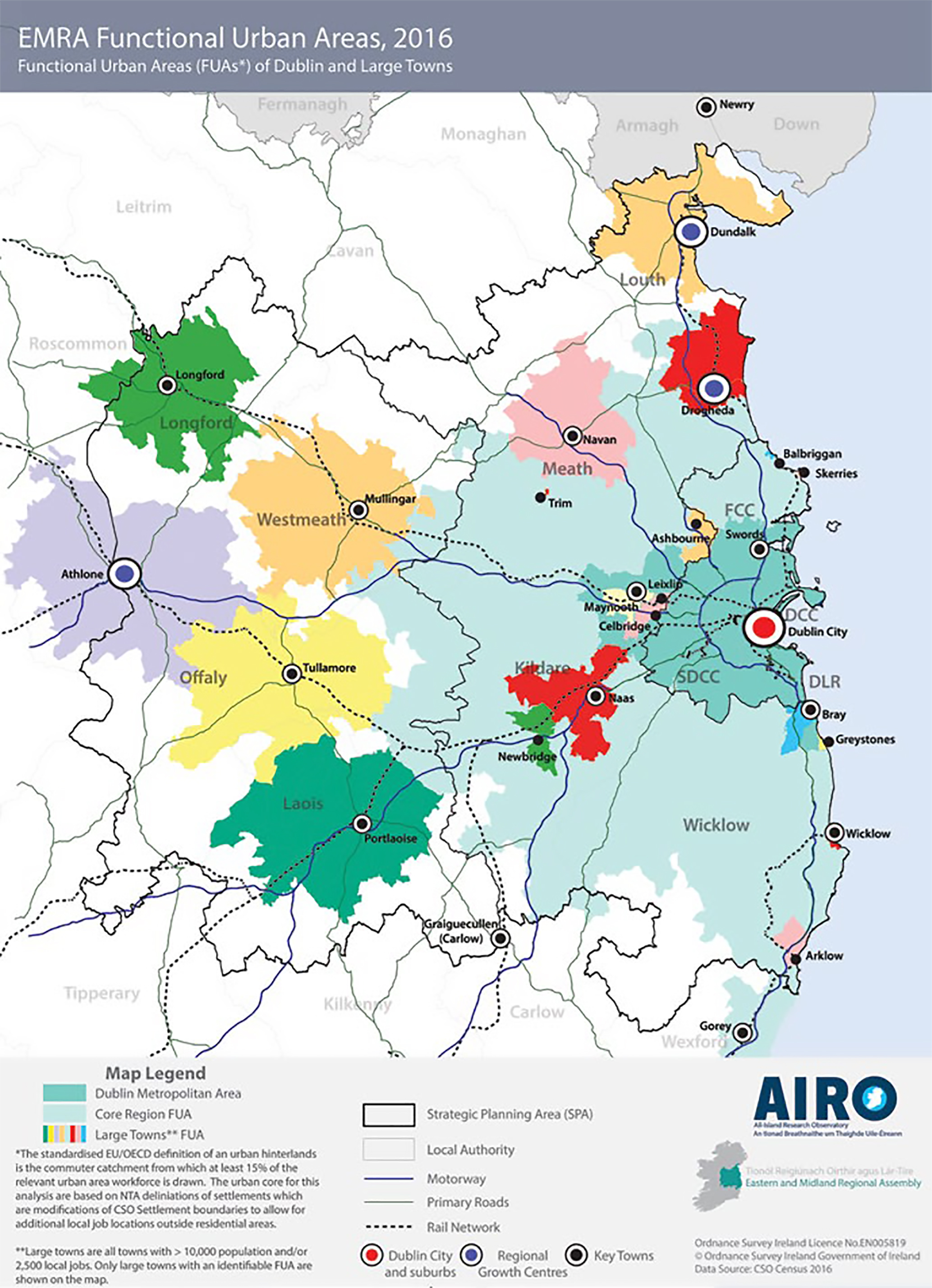
Figure 2.7: Functional Urban Areas, Dublin and Large Towns CSO 2016
Westmeath County Council is sensitive to the needs of the rural community and recognises the need to facilitate housing development for people who are an intrinsic part of a rural community.
The HNDA, as set out in Chapter 3 and Appendix 1, accounts for the potential demand for single rural dwellings over the lifetime of this Development Plan.
In establishing rural area typologies for County Westmeath, analysis was undertaken at Electoral Division (ED) level and incorporated a combination of socio-economic indicators and an assessment of demand for one-off housing across the county as well as considerations around proximity to the commuting catchment of large cities and towns. Specifically, the following core areas were examined:
-
Population change between 1996-2016
- This is deemed a core consideration in the determination of rural typology areas according to the Sustainable Rural Housing Guidelines (2005)
-
Projected population change between 2016-20264
- This analysis was undertaken to determine if population trends over the past two decades are likely to continue to 2026.
-
Economic Structure of the County
- The relative strength of the economic structure of the County’s ED’s was established through three core strands of analysis: CSO Annual Estimates of Income; the Pobal Deprivation Index5 (ED analysis for 2011 and 2016); and area designations under the CLAR Programme
-
Housing Demand
- Planning applications for one-off housing between 2014-2019 were assessed and mapped to determine which areas were under greater demand for development and those which were experiencing little or no demand.
Based on this analysis, the spatial extent of the areas deemed to be ‘Structurally Weak Rural Areas’ has been amended for this plan period. The areas are shown in the Core Strategy Map (see Figure 2.15) and described in the following sections.
2.14.1 Rural Area Under Strong Urban Influence
This area comprises most of the County and is characterised by stable population levels with well- developed town and village structures and a strong agricultural base. The objective in these areas is to maintain a stable population base in rural areas within a strong network of villages and small towns. The policy is to facilitate housing development by people who have strong links to the particular rural area, who are an intrinsic part of the rural community.
Such persons would normally have spent substantial periods of their lives living in the rural area as part of the established rural community, e.g. people employed in the rural area including farmers and their sons and daughters, people originally from the rural area and wishing to return, people wishing to reside near elderly parents to provide security and care, elderly parents wishing to live near other family members, people who would have grown up in rural areas seeking to build their home close to other family members, people working in rural areas such as teachers in rural schools.
The aim is to support the desire of individual applicants with strong rural links to settle in that area and to encourage people with no such links to settle in the identified extensive network of towns or villages.
2.14.2 Structurally Weak Rural Areas
The extent of the areas designated as a ‘structurally weak rural area’ have been amended for the 2021- 2027 Development Plan. These areas remain concentrated in a number of areas in the north and west of the County that have shown persistent and significant population decline in comparison to the stronger rural area. The policy in these areas is to accommodate demand from individuals for permanent residential development subject to good planning practice. This policy will facilitate the expansion of the rural population and the maintenance of essential local services. In these areas it is a requirement to distinguish between speculative house building and genuine long-term commitment to the area in question.
Figures 2.8, 2.9 and 2.10 below demonstrate population change in Westmeath at ED level between 1996- 2016; between 2011-2016; and projected population change between 2016-2016 respectively. This provides a broader indication of where higher and lower growth rates have been concentrated over time, as well as areas experiencing more persistent decline.
During the most recent Census period (2011-2016), the North West of the County displayed the highest overall concentration of population decline. Much of this area experienced rates of decline of between 0 and -4.9% between 2011 and 2016. However, some EDs experienced rates of decline of between -5% and -12%. This area includes the settlement of Ballinalack (notwithstanding the growth of one ED, Rathowen, by 14.1% during this period. It should be noted that this growth represented an increase of 45 people).
Overall, larger swathes of the northern and western County boundary area have been experiencing greater levels of population decline between 2011-2016. Much of these areas lie outside of the FUA’s of Athlone and Mullingar and are also projected to be characterised by slower growth rates up to 2026 (as per population projection analysis utilising the “Demographic Component Method”). Two out of three Westmeath EDs classified as ‘disadvantaged’ within the Pobal Deprivation Index in 2016 are located in this North west region. Almost all other EDs along the north and western boundary were classified as ‘marginally below average’ in 2016.
Core Strategy Policy Objectives
It is a Policy Objective of Westmeath County Council to:
CPO 2.9
Support the sustainable development of rural areas in Westmeath by encouraging growth and arresting decline in areas that have experienced low population growth or decline in recent decades and by managing the growth of areas that are under strong urban influence to avoid over-development, while sustaining vibrant rural communities.
CPO 2.10
Support the servicing of rural villages (serviced sites) to provide an alternative to one-off housing in the countryside, in line with RSES Objective RPO 4.78.
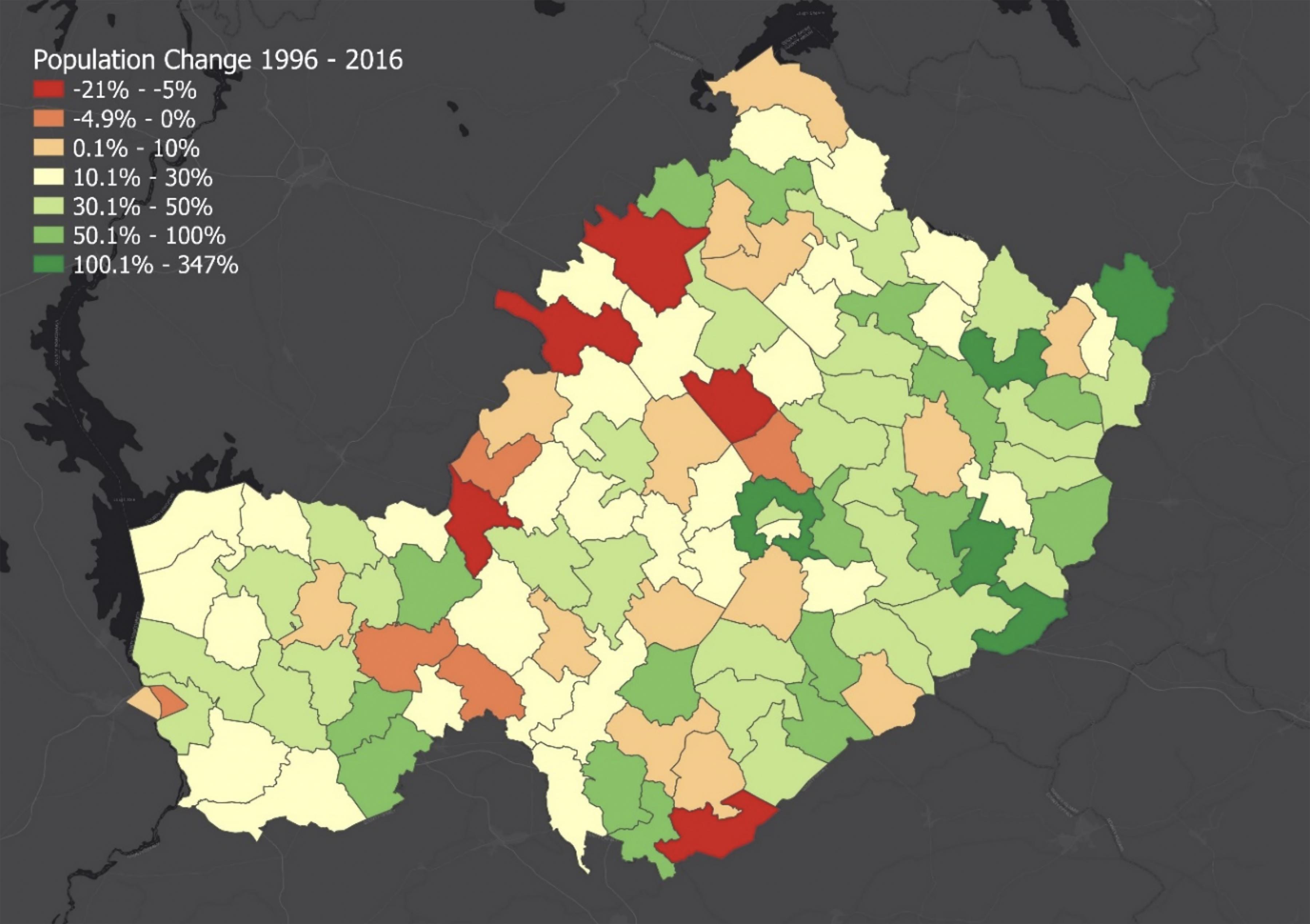
Figure 2.8: Population Change in Westmeath 1996-2016
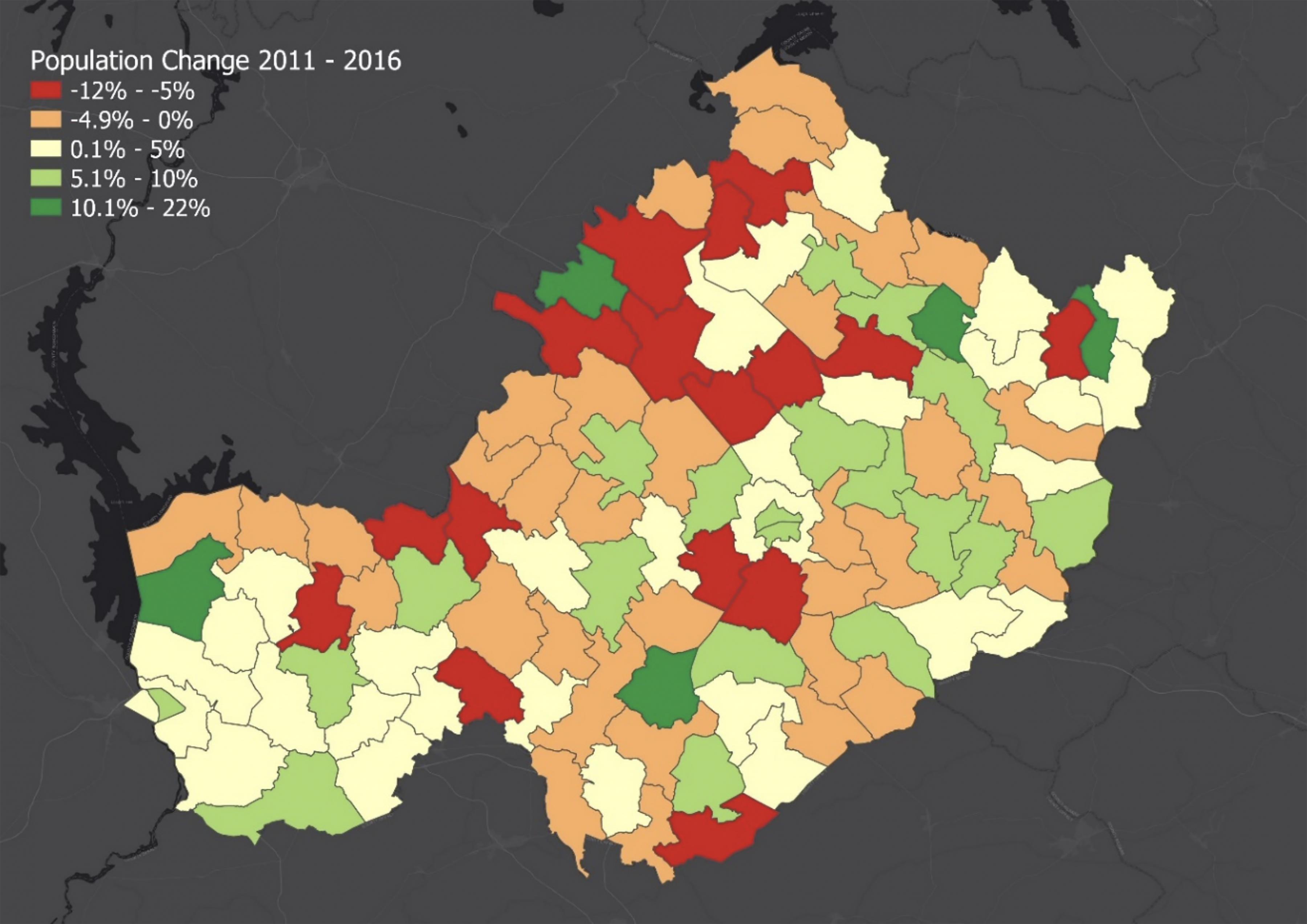
Figure 2.9: Population Change in Westmeath 2011-2016
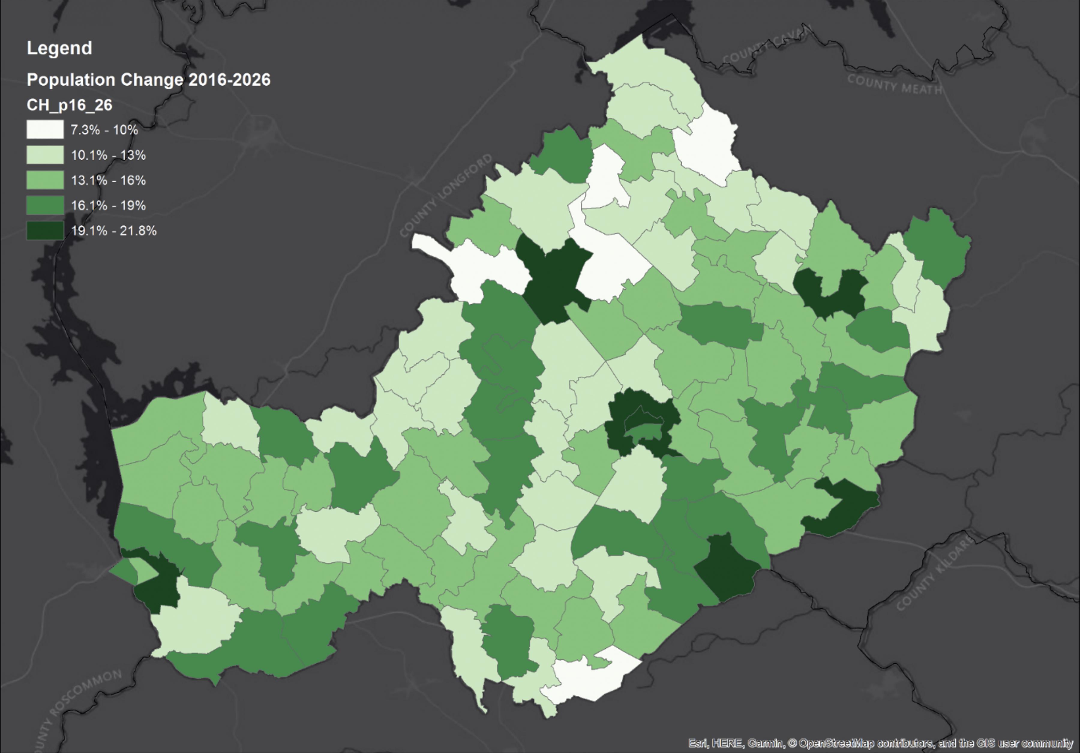
Figure 2.10: Projected Population Change in Westmeath 2016-2026
2.15 Economic Development
There were 57,625 people of working age (15-64 years) in County Westmeath in 2016. According to the 2016 census, 35,289 people (or 51.1%) residing in Westmeath recorded their principal economic status as being “at work”. 6666 persons or 9.7% reported being unemployed (i.e. those ‘Unemployed having lost or given up previous job’ and those ‘Looking for first regular job’ as recorded by the CSO). The comparable data for 2011 shows that 8,637 or 12.9% reported being unemployed.
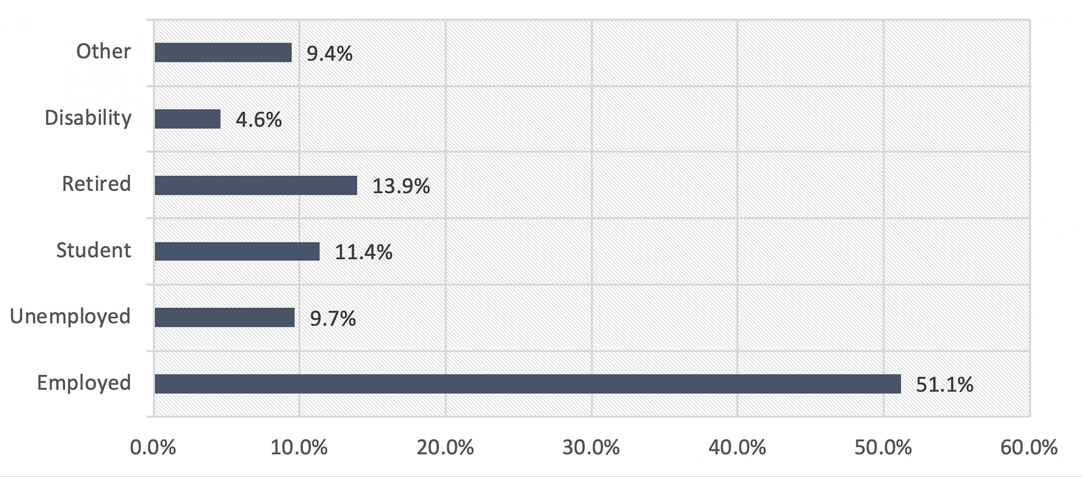
Figure 2.11: Population by Principal Economic Status
Figure 2.12 Illustrates the socio economic groupings of the population. The CSO socio-economic group classifies the population into one of ten categories based on the skill and educational attainment of their current or former occupation.
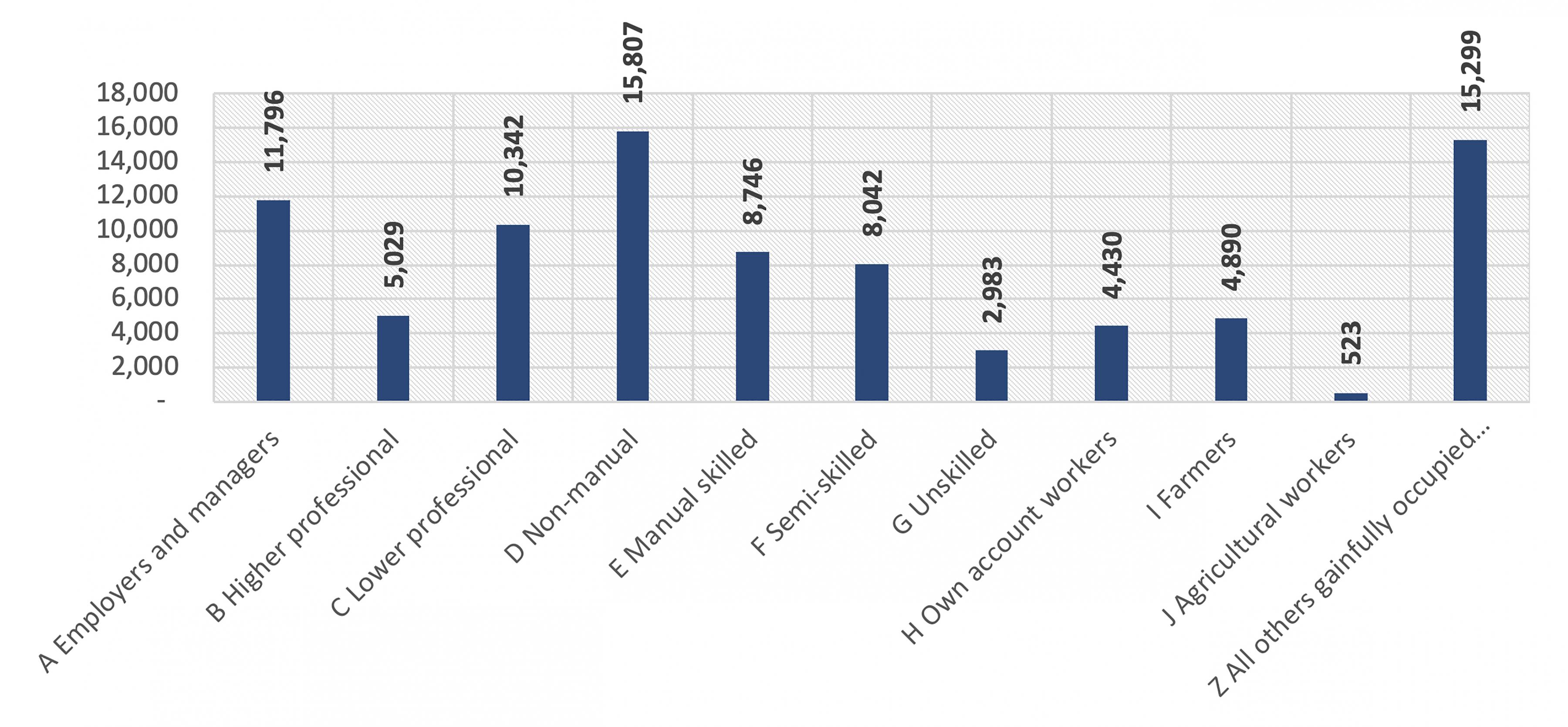
Figure 2.12: Population by Socio-economic group (CSO, 2016)
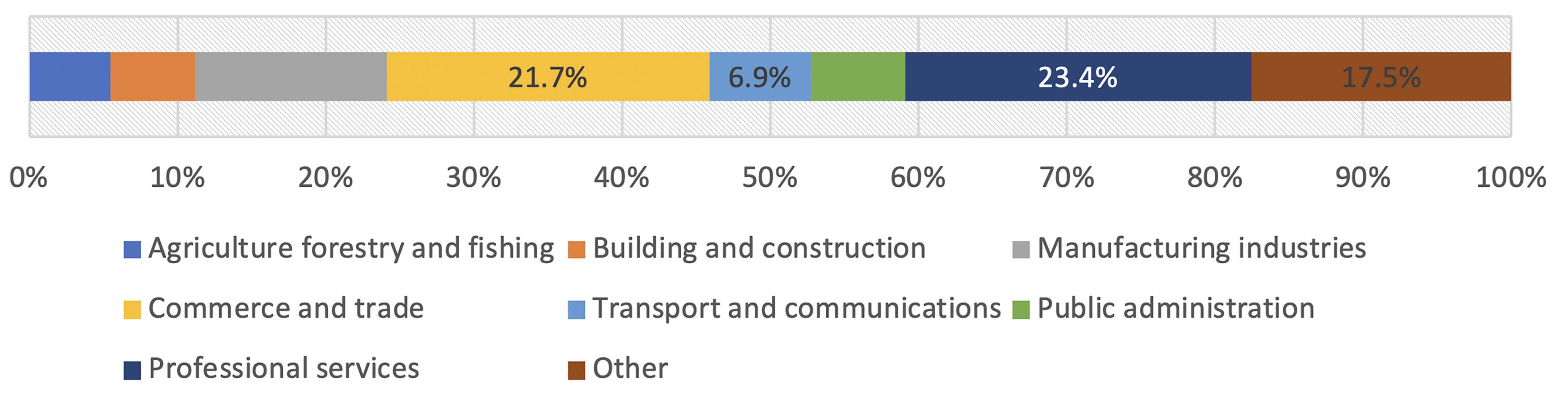
Figure 2.13: Local jobs by industry (CSO, 2016)
The Midlands Innovation and Research Centre (MIRC) together with Athlone Institute of Technology (AIT) and Athlone Business and Technology Park are important focal points for the development and strengthening of industry and higher education links in research and development (R&D) in the County. AIT is a leading third level institute with research capability in materials, bioscience and software, which are complementary to the industries in the Athlone area. In October 2019, Athlone Institute of Technology confirmed that it is forming a consortium with Limerick Institute of Technology to develop a new technological university (TU) for the Midlands and Mid-West.
2.16 Housing Stock and Capacity
Census 2016 results record a total housing stock of 36,890 in Westmeath, an increase of just 231 on 2011 levels. The number of occupied dwellings in Westmeath was 31,858. The average occupancy rate across the County was 2.76 persons per occupied dwelling which is marginally higher than the national rate of 2.75. Figure 2.14 demonstrates private households by size in 2016. This shows that 2-person households form the largest overall proportion of total households in Westmeath (28%).
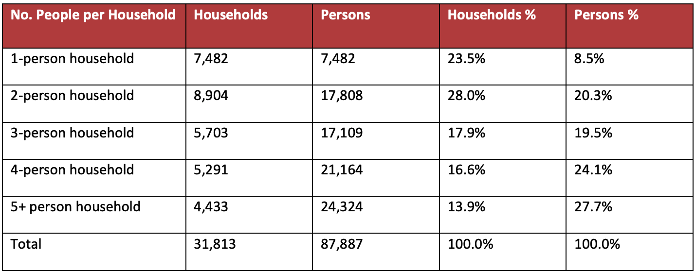
Figure 2.14: Private Households by Size (CSO, 2016)
89.9% of households comprised of a house or bungalow while 8.5% were apartments. Homeownership remains the dominant tenure with 69.2% of households within this category. 18.7% of households were in the private rental market while 8.0% were living in social housing. 3,728 or 10.1% of dwellings (excluding holiday homes) in the County were vacant in 2016.
2.16.1 Housing Land Requirements
This section sets out key considerations in relation to residential land requirements for this plan period as set out in the NPF and RSES. The NPF notes that the concept of headroom based solely on zoned land provision does not account for housing yield arising from the re-use of existing housing stock, mixed-use development, urban intensification or infill or brownfield development. Indeed, projected population growth must be planned in accordance with NPF National Policy Objectives 3a, b and c, which target infill and brownfield development within the existing built footprint of urban settlements, in particular the objective to target at least 30% of all new homes that are targeted in settlements other than the five Cities and their suburbs, within their existing built-up footprints.
As such, the NPF Roadmap population projections already incorporate 25% headroom figures for all parts of the country (Implementation Roadmap for the National Planning Framework, Appendix 2). This may be supplemented by additional 25% headroom, applicable in the 16 local authority areas that are projected to grow at or above the national average growth figure (page 5 of the NPF Roadmap). This further headroom may be applied regionally and locally, at RSES and City and County development plan stage. Westmeath is one of the sixteen local authority areas identified.
The average occupancy rate in Westmeath in 2016 was 2.76 compared to a state average of 2.75. However, the NPF states that this is expected to decline to around 2.5 by 2040, while also acknowledging that household sizes in urban areas tend to be smaller than in the suburbs or rural parts of the country. In line with this projected trend, a graduated average household size is utilised within this plan (see the Housing Strategy in Appendix 1).
Moreover, the NPF sets out a new, standardised methodology that addresses the differentiation between zoned land that is available for development and zoned land that requires significant further investment in services for infrastructure for development to be realised.
In this regard, lands have only been identified for development where they are able to connect to existing development services, i.e. road and footpath access including public lighting, foul sewer drainage, surface water drainage and water supply, for which there is service capacity available, and can therefore accommodate new development. These lands are also positioned within the existing built-up footprint of established settlements or contiguous to existing developed lands.
In considering the designation of lands in Athlone and Mullingar, regard is given to the availability of serviced lands as well as the identification of lands that are not currently sufficiently serviced to support new development but have potential to become fully serviced within the life of the plan.
2.16.2 Urban Regeneration and Development Fund (URDF) and the Rural Regeneration and Development Fund (RRDF)
One of the key objectives of the NPF relates to the need for compact growth, with development being focussed within and close to existing built-up areas. A core element of this approach is the regeneration of infill and brownfield sites. This is in line with the NPF targets of achieving at least 50% of all new homes within or contiguous to the built-up area of Dublin city and suburbs and a target of at least 30% for other urban areas. In this regard, it is a policy objective of Westmeath County Council to promote measures to reduce vacancy and the underuse of existing building stock and support initiatives that promote the reuse, refurbishment and retrofitting of existing buildings within urban centres. 30% of lands zoned for residential purposes as part of this Plan have been identified for brownfield development. These lands are primarily located outside Athlone and Mullingar where the greatest potential exists.
The importance of the role of regeneration in the delivery of Project Ireland 2040 is acknowledged by the provision of the Urban Regeneration and Development Fund (URDF) and the Rural Regeneration and Development Fund (RRDF).
Urban Regeneration and Development Fund (URDF)
The €2 Billion ten-year Urban Regeneration and Development Fund (URDF) was launched in 2018 to support compact sustainable development, through the regeneration of Ireland’s cities and large towns, in line with the objectives of Project Ireland 2040 – The National Planning Framework (NPF) and the National Development Plan (NDP) 2018 -2027. The Regional Spatial and Economic Strategy (RSES) provides the investment framework for Eastern and Midland Region. The types of proposals eligible for funding include strategic development areas, active land management, measures to address building vacancy and refurbishment, public realm improvements, enabling infrastructure, sustainable mobility and transition to low carbon and climate resilience. In 2019, 38 successful projects in the EMRA region were allocated over €42 million, of which nearly €15 million went to urban areas within the Dublin Metropolitan Area and over €27 million to support the rejuvenation of Regional Growth Centres and large towns in the region. As part of this first tranche of approvals, Westmeath County Council was awarded initial URDF support for a number of projects. For a full list of projects see section 7.6.3 of the plan.
Rural Regeneration and Development Fund (RRDF).
The Rural Regeneration and Development Fund is a commitment of €1 billion by government to be invested in rural Ireland over the period 2019 to 2027. The purpose of the fund is to support job creation in rural areas, address de-population of rural communities and support improvements in our towns and villages with a population of less than 10,000, and outlying areas. Initial funding of €315 million has been allocated to the fund on a phased basis over the period 2019 to 2022. It will be administered by the Department of Rural and Community Development. This Fund provides an opportunity to support the revitalisation of rural Ireland, to make a significant and sustainable impact on rural communities, and to address de-population in small rural towns, villages and rural areas. It will be a key instrument to support the objectives of the NPF and to aid in the implementation of the RSES and the Westmeath County Development Plan 2021-2027.
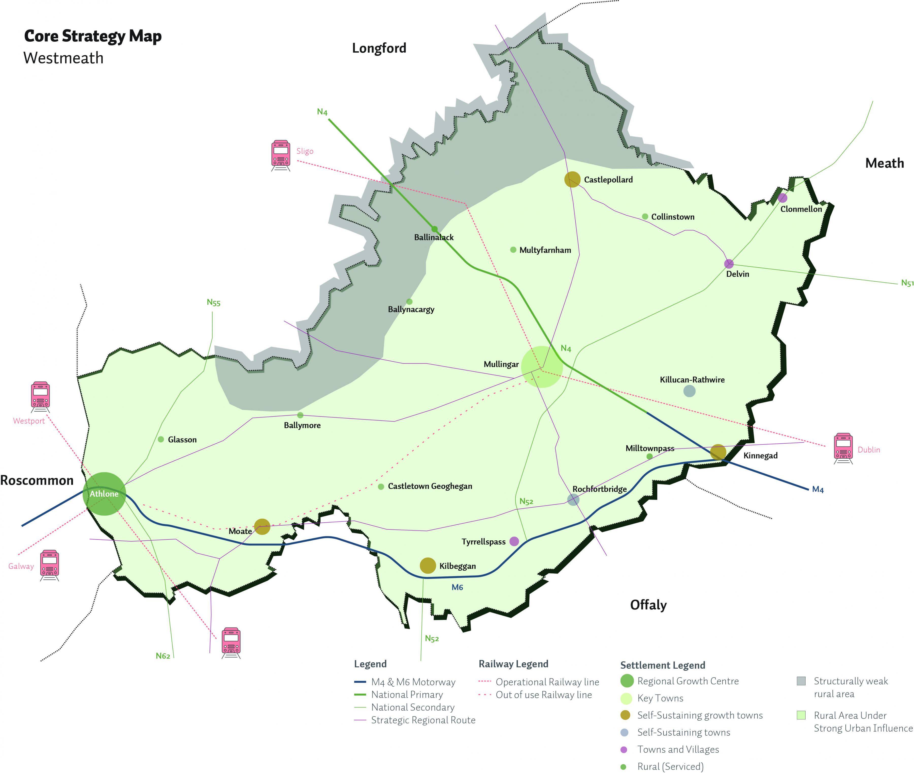
Figure 2.15: Core Strategy Map
2.17 Core Strategy Table
Following the population allocations set out in the Core Strategy Table, zoning maps are provided to reflect these figures and to indicate the quantum and locations of future development for the plan period. It is considered that the lands identified for residential development are sufficient to meet the population targets set out in the Core Strategy Table and reflect each settlements role in the Settlement Hierarchy. The amount and location of zoned lands required in each settlement was determined using an evidence-based settlement typology and asset-based approach, as detailed in Section 2.7.
In addition to the factors set out in table 2.3, consideration was also given to; ground and surface water vulnerability and any potential environmental impact (including SEA, HAD, EU Water Framework Directive, River Basin Management Plans and Flood Risk Management) requirements; availability of services and infrastructure; potential for economic and social development of the settlement; the sequential test; ground and surface water vulnerability; planning history and market availability/choice.
The amount and location of zoned lands required was also guided by the NPF and RSES requirements to promote consolidation of existing settlements and promote more compact forms of growth. The achievement of this, the NPF notes, has the potential to make a transformational difference. It can bring new life and footfall to existing settlements, contribute to the viability of services, shops and public transport, increase housing supply and enable more people to be closer to employment and recreational opportunities, as well as supporting a more sustainable transport mode shift.
In some instances there may be slight variations in terms of zoning provided as a result of the physical characteristics of sites on the ground, however in line with the NPF and RSES the release of lands will be prioritized in a sequential manner and monitoring will be employed to promote development patterns in line with the Core Strategy.
Table 2.8: Core Strategy Table
|
Settlements |
Population 2016 |
Population 2027 |
Population Change 2016-2027 |
Quantity of Land Area Required (Ha) 6 |
Land for Residential In this plan up to 2027 (Ha) 7 |
Brownfield 8 |
Infill |
Consolidation Sites (Ha) 9 |
Total Area Zoned 2021-2027 |
|
Regional Growth Centre |
|||||||||
|
Athlone (Ex. Monksland / Bealnamullia) |
16,612 |
22,154 |
5542 |
UAP |
> 30% |
> 30% |
|||
|
Key Town |
|||||||||
|
Mullingar |
20,928 |
26,003 |
5075 |
LAP |
> 30% |
> 30% |
|||
|
Self-Sustaining Growth Towns |
|||||||||
|
Castlepollard; |
1163 |
1399 |
236 |
5.15 |
5.65 |
0.61 |
1.64 |
4.90 |
6.63 |
|
Moate; |
2763 |
3325 |
562 |
12.26 |
11.68 |
5.62 |
5.22 |
3.95 |
12.47 |
|
Kinnegad; |
2754 |
3303 |
549 |
11.98 |
11.26 |
4.25 |
3.24 |
3.92 |
12.04 |
|
Kilbeggan; |
1288 |
1550 |
262 |
5.72 |
6.47 |
0 |
3.22 |
4.89 |
7.45 |
|
TOTAL |
35.11 |
35.06 |
10.48 |
13.32 |
17.66 |
38.59 |
|||
|
Self-Sustaining Towns |
|||||||||
|
Rochfortbridge; |
1473 |
1713 |
240 |
5.24 |
5.42 |
0 |
5.42 |
||
|
Killucan / Rathwire |
1370 |
1593 |
223 |
4.87 |
4.37 |
3.04 |
4.98 |
||
|
TOTAL |
10.11 |
9.79 |
3.04 |
10.40 |
|||||
|
Towns and Villages |
|||||||||
|
Clonmellon; |
664 |
759 |
95 |
3.45 |
3.15 |
1.76 |
3.50 |
||
|
Tyrrellspass; |
483 |
552 |
69 |
2.51 |
2.71 |
0 |
2.71 |
||
|
Delvin |
740 |
845 |
105 |
3.82 |
4.76 |
1.02 |
4.96 |
||
|
TOTAL |
9.78 |
10.62 |
2.78 |
11.17 |
|||||
|
Rural (Serviced) |
|||||||||
|
Multyfarnham, Ballymore, Ballynacargy, Ballinalack Milltownpass, Collinstown, Glasson, Castletown-Geoghegan. |
|||||||||
|
TOTAL |
13.03 |
12.87 |
1.07 |
13.16 |
|||||
|
Rural Remainder 10 |
|||||||||
|
Rural WM |
31,131 |
33,798 |
266711 |
||||||
2.18 Monitoring and Implementation
The NPF Implementation Roadmap states that the transitional level of population growth detailed to 2026 will provide sufficient scope to enable City and County Development Plans to be reviewed, land zonings to be prioritised and Local Area Plans and planning permissions to be worked through, ‘while also allowing for agility and ambition, as well as monitoring and review, as we move towards full implementation of the NPF and NDP’. In line with this, it is a policy objective of Westmeath County Council to monitor and review the operation and implementation of this Plan and to adjust as needed to ensure the effectiveness of its alignment with National and Regional policy and objectives. This will also ensure that any new statutory guidelines delivered under National Policy Objective 36 (as described in Section 2.2) are fully incorporated.
2.19 Core Strategy Policies and Objectives
Westmeath County Council shall ensure that the future spatial development of Westmeath is directed by means of a plan led approach, directing residential and employment generating development to locations in accordance with National and Regional Policy, and with environmental carrying capacity, which can support investment in public infrastructure and services and which is sensitive to the physical character of the built and natural environment. This approach is enshrined in a number of Core Strategy Policy Objectives, as below.
Core Strategy Policy Objectives
It is a Policy Objective of Westmeath County Council to:
CPO 2.11
Ensure that the future spatial development of Westmeath is in accordance with the National Planning Framework 2040 (NPF) including the population targets set out under the Implementation Roadmap, and the Regional, Spatial and the Economic Strategy (RSES) for the Eastern and Midland Region 2019-2031.
CPO 2.12
Implement all land use planning policy and objectives in a manner which takes account of and is consistent with the Core Strategy in order to accelerate a transition to a greener, low carbon and climate resilient county with a focus on reduced travel demand through the promotion of sustainable settlement patterns.
CPO 2.13
In the assessment of development proposals, to take account of transport corridors, environmental carrying capacity, availability and/or capacity to provide waste water and water supply services, potential to conflict with Water Framework Directive objectives, potential to impact on the integrity of European sites and Annexed Habitats and species, features of biodiversity value including ecological networks, impact on landscape and visual characteristics, education and other socioeconomic objectives
CPO 2.14
Promote the integration of land use and transportation policies and to prioritise provision for cycling and walking travel modes and the strengthening of public transport.
CPO 2.15
Support the regeneration of underused town centre and brownfield/infill lands along with the delivery of existing zoned and serviced lands to facilitate population growth and achieve sustainable compact growth targets of 30% of all new housing to be built within the existing urban footprint of targeted settlements in the County.
CPO 2.16
Promote measures to reduce vacancy and the underuse of existing building stock and support initiatives that promote the reuse, refurbishment and retrofitting of existing buildings within urban centres and targeted settlements in the County.
CPO 2.17
Incorporate, in the content of the County Development Plan, measures in accordance with Section 10 (n) of the Planning and Development Acts 2000 (as amended) for the promotion of sustainable settlement and transportation strategies in urban and rural areas including the promotion of measures to — (i) reduce energy demand in response to the likelihood of increases in energy and other costs due to long-term decline in non-renewable resources, (ii) reduce anthropogenic greenhouse gas emissions, and (iii) address the necessity of adaptation to climate change; in particular, having regard to location, layout and design of new development.
2.20 Conclusion
Ecosystem Services Approach
In preparing the Draft Plan and developing policy objectives, the Council have followed these Ecosystem Services Approach principles:
- Consideration of natural systems - by using knowledge of interactions in nature and how ecosystems function (including at Plan Chapters 6 “Tourism”, 10 “Transport, Infrastructure & Energy”, 11 “Climate Action”, 12 “Natural Heritage and Green Infrastructure” and 13 “Landscape and Lake Amenities”)
- Taking into account of the services that ecosystems provide - including those that underpin social and economic well-being, such as flood and climate regulation (including at Plan Chapters 11 “Climate Action”), resources for food, fibre or fuel (including at Chapter 9 “Rural Westmeath”), or for recreation, culture and quality of life (including at Plan Chapters 12 “Natural Heritage and Green Infrastructure”, 13 “Landscape and Lake Amenities” and 14 “Cultural Heritage”).
- Involving people - those who benefit from the ecosystem services and those managing them need to be involved in decisions that affect them. Public consultation has informed the preparation of the Draft Plan which will be further refined before adoption, taking into account submissions/observations made on the Draft Plan during public display.
The Council shall promote an Ecosystem Services Approach, following the above principles, in its decision-making processes, including those relating to the preparation of statutory land use plans.
In recognition of the need to manage natural capital, provisions have been integrated into the Plan that will contribute towards management of air quality, noise pollution, light pollution, water quality and integrated catchment management.
Implementation and Monitoring
The NPF states that new statutory guidelines, supported by wider methodologies and data sources, will be put in place under Section 28 of the Planning and Development Act to improve the evidence base, effectiveness and consistency of the planning process for housing provision at regional, metropolitan and local authority levels. This will be supported by the provision of standardised requirements by regulation for the recording of planning and housing data by the local authorities in order to provide a consistent and robust evidence base for housing policy formulation. As such, Westmeath County Council, as set out in section 2.18, will monitor ongoing developments in this respect and review the operation and implementation of this Plan. This includes adjustments as needed to ensure the effectiveness of its alignment with National and Regional policy and objectives.
Core Strategy Policy Objectives
It is a Policy Objective of Westmeath County Council to:
CPO 2.18
Monitor development for compliance with the objectives of the Core Strategy and adjust, where necessary, the approach taken to the consideration of development proposals in order to ensure effective alignment with National and Regional policy and objectives.
- 1- The CSO defines a settlement of more than 1,500 people as ‘urban’.
- 2- A forecast is based upon assumptions reflecting conditions expected to exist, i.e. the impact of policy, whereas a projection is prepared to present one or more hypothetical courses which might develop, should the trajectory of growth align with the key assumptions used.
- 3- As part of the Census 2016 processing programme places of work, school and college were geo-coded. All workers resident in Ireland on Census night were coded to their place of work and all Irish resident students from the age of 5 and upwards were coded to their place of school/college. A detailed microdata file containing demographic and socio- economic characteristics of these residents along with information on the origin and destination of their journeys has been made available for analysis.
- 4- Population projection analysis was undertaken to 2026 utilising the “Demographic Component Method” that integrates the dynamic components of population change namely, mortality, fertility and migration, and enables age cohort analysis
- 5- The index provides a method of measuring the relative affluence or disadvantage of a particular geographical area using data compiled from various censuses.
- 6- Quantity of land area required for Athlone and Mullingar to be determined under respective UAP and LAP reviews in line with National and Regional policy objectives.
- 7- Residential lands identified for development for Athlone and Mullingar to be identified in the Athlone Urban Area Plan and Mullingar Local Area Plan in line with Core Strategy requirements.
- 8- Infill/Brownfield site – As per 3(a) “Implementation Roadmap for the National Planning Framework” and identified in reference to designated categories of settlement types (Note - most of the brownfield potential exists in the top tier settlements of Athlone and Mullingar). 68% lands Brownfield/Infill lands identified as per the CSO 2016 SAP boundary.
- 9- Consolidation Sites - Based on historic development trends 20% is the maximum extent of residential development envisaged on these lands over the Plan period. Specific regeneration proposals (non-residential) for Opportunity Sites are identified at Chapter 14 Settlement Plans.
- 10- Rural Remainder – Includes established Rural Villages of Ballinagore, Ballykeeran, Coole, Raharney, Rathowen, and settlement Nodes as set out in the Settlement Hierarchy.
- 11- Housing Needs Demand Assessment (HNDA) presented in Appendix 1 assesses the potential demand for single rural dwellings during the lifetime of the plan. Draft Westmeath County Development Plan 2021-2027
Clár ábhair
Tuairimí
Tuairimí
Submission from the Northern and Western Regional Assembly (NWRA) re: Observations and comments relating to the the entire Draft County Development Plan
Submission from An Taisce re: Observations to the Draft County Development Plan
Please see the attached document for An Taisce's submission.
Submission from Longford Westmeath Green Party Recommendations for the Westmeath County Development Plan
28/06/20
To whom it may concern,
I am writing on behalf of the Longford Westmeath branch of the Green Party. We wish to make a submission for...
Submission from Land Development Agency re: Columb Military Barracks Mullingar
Please acknowledge receipt of our submission